Tel : +63(2)-7729-8168
|
Email Us : gallery@gop.com.ph
My Account
Remember Me
Register
18 Item(s)
-
₱
723,500.00
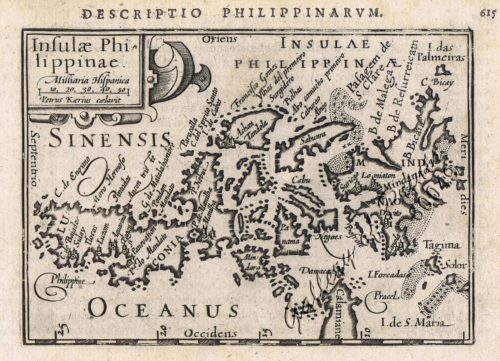
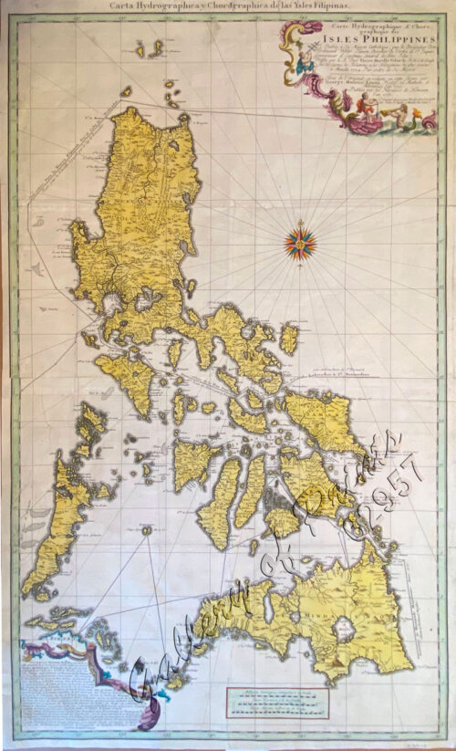
Insulae Philippinae
1 x
₱
220,000.00
Memorias de la Real Academia de Ciencias Exactas, Fisicas y Naturales de Madrid Tomo XIV. - Atlas Estudios Preliminares Sobre La Fauna Malacológica de las Islas Filipinas.
1 x
₱
13,200.00
Carayas ou machines a pecher et Banka de Manille. ["Tarayas" (correctly called "Salambas") or fishing contraptions; and "Banka" from Manila]
1 x
₱
99,000.00
[Emperor Moth]
1 x
₱
6,600.00
Eene audiente bij den Sultan van Soeloe
1 x
₱
11,000.00
Sticklebacks 1. Rough - tailed 2. Half - armed 3. Smooth - tailed 4. Short - spined 5. Four - spined 6. Ten - spined
1 x
₱
5,500.00
Harper's Weekly - A Journal of Civilization with frontispiece: The Sovereigns at the with frontispiece: In The Bitter Cold.
1 x
₱
11,000.00
The Story of Maps. Putting the World in Perspective
1 x
₱
3,900.00
Harper's Weekly - A Journal of Civilization with frontispiece: Ice-Yachting-Hard-A-Lee! Drawn by W. P. Snyder.
1 x
₱
7,700.00
China Sea - Macclesfield Bank. Surveyed by Commander W.U. Moore and the Officers of H.M. Surveying Ship Penguin, 1892. and by Commander A. Mostyn Field and the Officers of H.M. Surveying Ship Egeria,1893.
1 x
₱
6,600.00
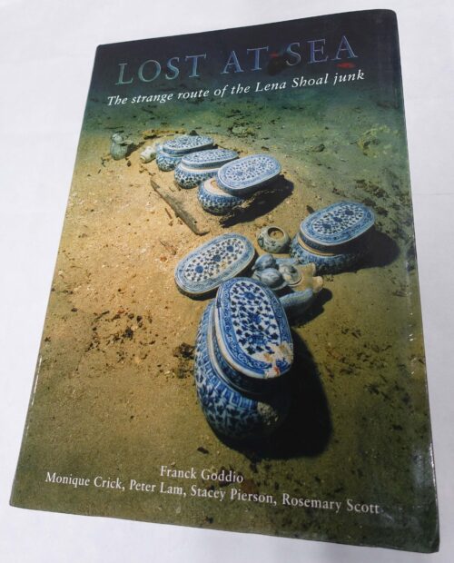
Lost at Sea. The strange route of the Lena Shoal junk
1 x
₱
5,900.00
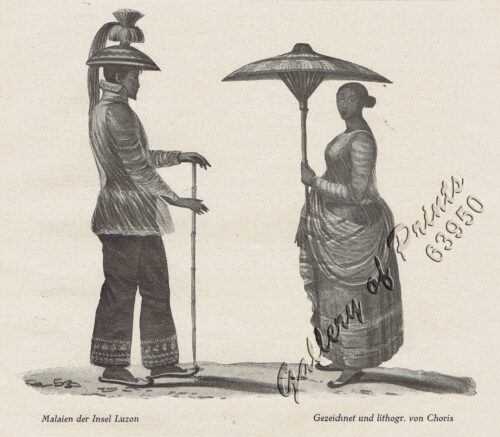
Malaien der Insel Luzon [Malay of Luzon Island]
1 x
₱
6,600.00
A Boat Girl at Canton
1 x
₱
4,400.00
Philippine Islands. Tablas Strait with Part of Sibuyan Sea. From the United States Government Charts of 1935.
1 x
₱
11,000.00
Philippine Islands. Anchorages in Northern Luzon and the Babuyan Islands. Insets: 1) Babuyan Is. - Fuga I. Musa Bay. From the United States Government Chart to 1931. 2) Babuyan Is. - Camiguin I. Port San Pio Quinto. From the United States Government Chart to 1931. 3) Luzon-North-East Coast Port San Vicente. From the United States Government Chart to 1938. 4) Luzon - East Coast Mauban Anchorage. From the Philippine Government Chart of 1957. 5) Luzon - West Coast. Salomague Harbour and Lapog Bay. From the United States Government Chart of 1934. 6) Luzon - West Coast Port Currimao and Gan Bay. From the United States Government Chart of 1934. 7) Luzon - West Coast Solvec Cove. From the United States Government Chart of 1934. 8) Luzon - West Coast Lingayen Gulf. Port Sual with Cabalitian Bay. From the United States Government Chart of 1922. 9) Luzon - West Coast San Fernando Harbour. From the United States Government Chart of 1936.
1 x
₱
11,000.00
China Sea - Palawan - East Coast - Port Royalist (P.to Princesa de Asturias of the Spanish). Surveyed by Comr. W.T. Bate R.N. Assisted by Lt C. Pasco, C. Bullock, Mate & W.B. Colver 2nd Master H.M.S/ Royalist 1850
1 x
₱
6,600.00
Lost Islands : The Story of Islands That Have Vanished from Nautical Charts
1 x
₱
3,500.00
Campagnard Tagal, pres de Manille (Iles Philippines.) [Tagalog Man from the Countryside near Manila]
1 x
₱
290,000.00
View Cart
Checkout
Home
About Us
Publications
Shop Online
Framing Services
Exhibits
Picture Hanging System
Contact Us
View cart
“Campagnard Tagal, pres de Manille (Iles Philippines.) [Tagalog Man from the Countryside near Manila]” has been added to your cart.
Sort by
Price
Sort by
Default Order
Sort by
Name
Sort by
Price
Sort by
Date
Sort by
Popularity
Show
30 Products
Show
30 Products
Show
60 Products
Show
90 Products
Insulae Philippinae
₱
135,000.00
Add to cart
Details
Carte des Îles Philippines, Célebès et Moluques….Duperr...
₱
140,000.00
Add to cart
Details
Détroit de Bassilan (Iles Philippines) [sic] [Strait of Ba...
₱
140,000.00
Add to cart
Details
Manille, Pont sur le Passig
₱
143,000.00
Add to cart
Details
A Chart of the Coast of China from Cambodia to Nanquam with ...
₱
155,000.00
Add to cart
Details
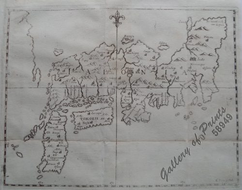
Indiae Orientalis insularumque adiacientium typus
₱
156,000.00
Add to cart
Details
Mapa de las Islas Filipinas
₱
160,000.00
Add to cart
Details
[Luzon & Visayas]]
₱
165,000.00
Add to cart
Details
[Luzon & Visayas]]
₱
165,000.00
Add to cart
Details
Carte de la Mer de Chine… par M. Daussy,… capitaine Hors...
₱
166,000.00
Add to cart
Details
China
₱
184,000.00
Add to cart
Details
Insulae Indiae Orientalis praecipuae, In quibus Moluccae cel...
₱
185,000.00
Add to cart
Details
Insulae Indiae Orientalis praecipuae, In quibus Moluccae cel...
₱
185,000.00
Add to cart
Details
Insulae Indiae Orientalis praecipuae, In quibus Moluccae cel...
₱
185,000.00
Add to cart
Details
Plan de Manila, su bahia y puerto de Cavite
₱
220,000.00
Add to cart
Details
Insulae Philippinae
₱
220,000.00
Add to cart
Details
Campagnard Tagal, pres de Manille (Iles Philippines.) [Taga...
₱
290,000.00
Add to cart
Details
Entrée de la baie de Manille, (Iles Philippines) Entrevue n...
₱
298,000.00
Add to cart
Details
Pont de Manille (Iles Philippines.) [Manila Bridge (Philipp...
₱
330,000.00
Add to cart
Details
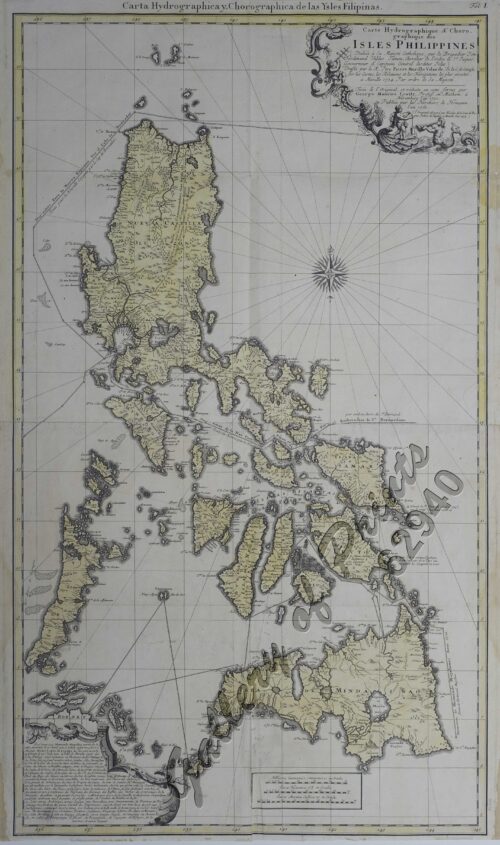
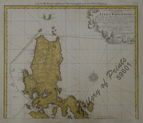
Carte Hydrographique & Chorographique des Isles Philippi...
₱
425,000.00
Add to cart
Details
Carte Hydrographique & Chorographique des Isles Philippi...
₱
425,000.00
Add to cart
Details
[Carte Reduite] Carte Réduite des Isles Philippines Pour Se...
₱
425,000.00
Add to cart
Details
[Carte Reduite] Carte Réduite des Isles Philippines Pour Se...
₱
425,000.00
Add to cart
Details
[Carte Reduite] Carte Réduite des Isles Philippines Pour Se...
₱
450,000.00
Add to cart
Details
Iaponia [Japan]
₱
456,000.00
Add to cart
Details
Carte Hydrographique & Chorographique des Isles Philippi...
₱
475,000.00
Add to cart
Details
Carte Hydrographique & Chorographique des Isles Philippi...
₱
520,000.00
Add to cart
Details
Historia de la Provincia de Philipinas de la Compañia de Je...
₱
550,000.00
Add to cart
Details
A Chart of the China Sea, and Philippine Islands, with the A...
₱
780,000.00
Add to cart
Details
Carte tres curieuse de la mer du sud, contenant des remarque...
₱
790,000.00
Add to cart
Details
Previous
1
2
3
…
46
47
48
49
50
Next
Shopping Cart
Campagnard Tagal, pres de Manille (Iles Philippines.) [Tagalog Man from the Countryside near Manila]
1
Lost Islands : The Story of Islands That Have Vanished from Nautical Charts
1
China Sea - Palawan - East Coast - Port Royalist (P.to Princesa de Asturias of the Spanish). Surveyed by Comr. W.T. Bate R.N. Assisted by Lt C. Pasco, C. Bullock, Mate & W.B. Colver 2nd Master H.M.S/ Royalist 1850
1
Philippine Islands. Anchorages in Northern Luzon and the Babuyan Islands. Insets: 1) Babuyan Is. - Fuga I. Musa Bay. From the United States Government Chart to 1931. 2) Babuyan Is. - Camiguin I. Port San Pio Quinto. From the United States Government Chart to 1931. 3) Luzon-North-East Coast Port San Vicente. From the United States Government Chart to 1938. 4) Luzon - East Coast Mauban Anchorage. From the Philippine Government Chart of 1957. 5) Luzon - West Coast. Salomague Harbour and Lapog Bay. From the United States Government Chart of 1934. 6) Luzon - West Coast Port Currimao and Gan Bay. From the United States Government Chart of 1934. 7) Luzon - West Coast Solvec Cove. From the United States Government Chart of 1934. 8) Luzon - West Coast Lingayen Gulf. Port Sual with Cabalitian Bay. From the United States Government Chart of 1922. 9) Luzon - West Coast San Fernando Harbour. From the United States Government Chart of 1936.
1
Philippine Islands. Tablas Strait with Part of Sibuyan Sea. From the United States Government Charts of 1935.
1
A Boat Girl at Canton
1
Malaien der Insel Luzon [Malay of Luzon Island]
1
Lost at Sea. The strange route of the Lena Shoal junk
1
China Sea - Macclesfield Bank. Surveyed by Commander W.U. Moore and the Officers of H.M. Surveying Ship Penguin, 1892. and by Commander A. Mostyn Field and the Officers of H.M. Surveying Ship Egeria,1893.
1
Harper's Weekly - A Journal of Civilization with frontispiece: Ice-Yachting-Hard-A-Lee! Drawn by W. P. Snyder.
1
The Story of Maps. Putting the World in Perspective
1
Harper's Weekly - A Journal of Civilization with frontispiece: The Sovereigns at the with frontispiece: In The Bitter Cold.
1
Sticklebacks 1. Rough - tailed 2. Half - armed 3. Smooth - tailed 4. Short - spined 5. Four - spined 6. Ten - spined
1
Eene audiente bij den Sultan van Soeloe
1
[Emperor Moth]
1
Carayas ou machines a pecher et Banka de Manille. ["Tarayas" (correctly called "Salambas") or fishing contraptions; and "Banka" from Manila]
1
Memorias de la Real Academia de Ciencias Exactas, Fisicas y Naturales de Madrid Tomo XIV. - Atlas Estudios Preliminares Sobre La Fauna Malacológica de las Islas Filipinas.
1
Insulae Philippinae
1
Cart
Checkout
Continue Shopping
18