Tel : +63(2)-7729-8168
|
Email Us : gallery@gop.com.ph
My Account
Remember Me
Register
40 Item(s)
-
₱
2,166,480.00
Insulae Philippinae
1 x
₱
220,000.00
Memorias de la Real Academia de Ciencias Exactas, Fisicas y Naturales de Madrid Tomo XIV. - Atlas Estudios Preliminares Sobre La Fauna Malacológica de las Islas Filipinas.
1 x
₱
13,200.00
Carayas ou machines a pecher et Banka de Manille. ["Tarayas" (correctly called "Salambas") or fishing contraptions; and "Banka" from Manila]
1 x
₱
99,000.00
[Emperor Moth]
1 x
₱
6,600.00
Eene audiente bij den Sultan van Soeloe
1 x
₱
11,000.00
Sticklebacks 1. Rough - tailed 2. Half - armed 3. Smooth - tailed 4. Short - spined 5. Four - spined 6. Ten - spined
1 x
₱
5,500.00
Harper's Weekly - A Journal of Civilization with frontispiece: The Sovereigns at the with frontispiece: In The Bitter Cold.
1 x
₱
11,000.00
The Story of Maps. Putting the World in Perspective
1 x
₱
3,900.00
Harper's Weekly - A Journal of Civilization with frontispiece: Ice-Yachting-Hard-A-Lee! Drawn by W. P. Snyder.
1 x
₱
7,700.00
China Sea - Macclesfield Bank. Surveyed by Commander W.U. Moore and the Officers of H.M. Surveying Ship Penguin, 1892. and by Commander A. Mostyn Field and the Officers of H.M. Surveying Ship Egeria,1893.
1 x
₱
6,600.00
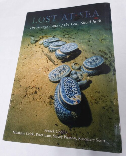
Lost at Sea. The strange route of the Lena Shoal junk
1 x
₱
5,900.00
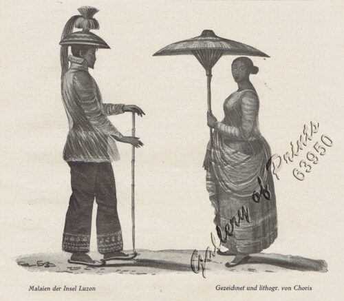
Malaien der Insel Luzon [Malay of Luzon Island]
1 x
₱
6,600.00
A Boat Girl at Canton
1 x
₱
4,400.00
Philippine Islands. Tablas Strait with Part of Sibuyan Sea. From the United States Government Charts of 1935.
1 x
₱
11,000.00
Philippine Islands. Anchorages in Northern Luzon and the Babuyan Islands. Insets: 1) Babuyan Is. - Fuga I. Musa Bay. From the United States Government Chart to 1931. 2) Babuyan Is. - Camiguin I. Port San Pio Quinto. From the United States Government Chart to 1931. 3) Luzon-North-East Coast Port San Vicente. From the United States Government Chart to 1938. 4) Luzon - East Coast Mauban Anchorage. From the Philippine Government Chart of 1957. 5) Luzon - West Coast. Salomague Harbour and Lapog Bay. From the United States Government Chart of 1934. 6) Luzon - West Coast Port Currimao and Gan Bay. From the United States Government Chart of 1934. 7) Luzon - West Coast Solvec Cove. From the United States Government Chart of 1934. 8) Luzon - West Coast Lingayen Gulf. Port Sual with Cabalitian Bay. From the United States Government Chart of 1922. 9) Luzon - West Coast San Fernando Harbour. From the United States Government Chart of 1936.
1 x
₱
11,000.00
China Sea - Palawan - East Coast - Port Royalist (P.to Princesa de Asturias of the Spanish). Surveyed by Comr. W.T. Bate R.N. Assisted by Lt C. Pasco, C. Bullock, Mate & W.B. Colver 2nd Master H.M.S/ Royalist 1850
1 x
₱
6,600.00
Lost Islands : The Story of Islands That Have Vanished from Nautical Charts
1 x
₱
3,500.00
Campagnard Tagal, pres de Manille (Iles Philippines.) [Tagalog Man from the Countryside near Manila]
1 x
₱
290,000.00
The Murillo Bulletin, Journal of PHIMCOS, Special World War II Issue
1 x
₱
600.00
Gallicolumba keayi [Negros Puñalada]
1 x
₱
5,500.00
Traubige Passionsblume. Fig. 921. [Grapy Passionflower]; Vierkantige Passionsblume. Fig. 922. [Tetragonal Passionflower]; Rothe Passionsblume. Fig. 923. [Red Passionflower]; Aepfeltragende Passionsblume. Fig. 924. [Apple-carrying Passionflower]; Carminrothe Passionsblume. Fig. 925 [Carmine-red Passionflower]
1 x
₱
5,500.00
Carte des Iles Philippines Pour servirà l'intelligence de l'ouvrage sur les Possessions Espagnoles dans l'Océanie, par Mr. J. Mallat. inset: Iles Batanes
1 x
₱
980,000.00
Der Vulkan von Taal auf Luzon
1 x
₱
7,700.00
Codiaeum Variegatum. Rump. [English: Croton] [Local Names: San Francisco / Deliciosa]
1 x
₱
26,400.00
[Luzon & Visayas]]
1 x
₱
165,000.00
To U.S. Military Welcome to Manila and USO Club, Manila Hotel
1 x
₱
1,200.00
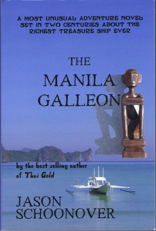
The Manila Galleon
1 x
₱
2,900.00
Philippine Islands. Samar and Leyte. San Juanico Strait and Approaches. From the United States Government Surveys to 1935. With Additions and Corrections from the Philippine Gov't. Charts to 1957. inset: 1) Northern Entrance to San Juanico Strait. From the United States Government Surveys of 1925. With Additions and Corrections from the Philippine Gov't. Charts to 1957.
1 x
₱
11,000.00
1) Chrysocolaptes lucidus erythrocephalus [Red-faced Golden Woodpecker (male type specimen)]. 2) Chrysocolaptes lucidus maculiceps [Basilan Crimson-backed Woodpecker (type specimen young female)]
1 x
₱
5,500.00
Perücken-Sumach. Fig. 1072. [Smoke-tree/PurpleSmoke bush]; Westindische Nierenfrucht. Fig. 1073. [West Indian Cashew Nut]; Aechter Mangobaum. Fig. 1074. [Genuine Mangotree]; Purpurrothe Mombinpflaume. Fig. 1075. [Purple Mobinplum]
1 x
₱
5,500.00
El Sitio de Manila (1898). Memorias de un voluntario
1 x
₱
6,600.00
[Sailing Boat] [illegible title]
1 x
₱
5,500.00
Musa Coccinea. Andr. [Tagalog: Flowering Banana]
1 x
₱
34,100.00
Girls Bathing
1 x
₱
6,600.00
Plan of the Bay of Manilla in the Isle of Luconia, the Principal of the Philippine Islands, Surveyed by Señor Alexandro Malaspina and Communicated By Captn. G.G. Richardson.
1 x
₱
120,000.00
Zeocephus Cinnamomeus (Fig. 1) [Rufous Paradise Flycatcher] Z. Cyanescens (Fig. 2), pl.48 [Blue Paradise Flycatcher]
1 x
₱
22,000.00
The Story of the Philippines and our new Possessions
1 x
₱
4,980.00
Interior of the Crater of the Volcano at Taal
1 x
₱
8,800.00
Enciclopedia Hispano-Americana Manual de Barnices y Preparacion de Charoles segun los procederes mas recientes. [Manual of Varnishes and Preparation of Patent Leathers according to the most recent procedures.]
1 x
₱
6,600.00
China Sea. Philippine Islands. San Bernardino Strait and Approaches. From the United States Coast Survey Charts to 1923. With Additions and corrections to 1934
1 x
₱
11,000.00
View Cart
Checkout
Home
About Us
Publications
Shop Online
Framing Services
Exhibits
Picture Hanging System
Contact Us
View cart
“China Sea. Philippine Islands. San Bernardino Strait and Approaches. From the United States Coast Survey Charts to 1923. With Additions and corrections to 1934” has been added to your cart.
Sort by
Date
Sort by
Default Order
Sort by
Name
Sort by
Price
Sort by
Date
Sort by
Popularity
Show
30 Products
Show
30 Products
Show
60 Products
Show
90 Products
China Sea – Macclesfield Bank. Surveyed by Commander W...
₱
6,600.00
Add to cart
Details
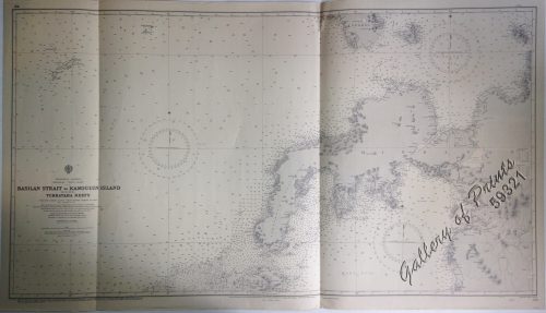
Philippine Islands Mindanao – West Coast – Basil...
₱
11,000.00
Add to cart
Details
Philippine Islands. Tagolo Point to Cuyo Islands. Including ...
₱
11,000.00
Add to cart
Details
Philippine Islands. Mindoro Strait. From the United States G...
₱
11,000.00
Add to cart
Details
Philippine Islands. Tablas Strait with Part of Sibuyan Sea. ...
₱
11,000.00
Add to cart
Details
Philippine Islands. Verde Island Passage. From the United St...
₱
11,000.00
Add to cart
Details
Philippine Islands. Samar and Leyte. San Juanico Strait and ...
₱
11,000.00
Add to cart
Details
Philippine Islands. The Passages Between Panay. Negros and C...
₱
11,000.00
Add to cart
Details
Philippine Islands. Cuyo East Pass. From the United States G...
₱
11,000.00
Add to cart
Details
Philippine Islands. Luzon Island. North of Latitude 16° 20...
₱
11,000.00
Add to cart
Details
Philippine Islands. Western Part of Mindanao Sea with Bohol ...
₱
11,000.00
Add to cart
Details
Philippine Islands. Sibuyan Sea to San Bernardino Strait. Fr...
₱
11,000.00
Add to cart
Details
Philippine Islands. Camotes Sea with Canigao Chanel. From th...
₱
11,000.00
Add to cart
Details
Philippine Islands. Leyte Gulf To Mayo Bay. Including Leyte,...
₱
11,000.00
Add to cart
Details
Philippine Islands. Mindoro and Adjacent Islands. Cuyo Is. T...
₱
11,000.00
Add to cart
Details
Philippine Islands. Luzon-West and East Coasts. Cabra I. to ...
₱
11,000.00
Add to cart
Details
Philippine Islands. Luzon Island. North of Latitude 16° 20...
₱
11,000.00
Add to cart
Details
Philippine Islands. Anchorages in Northern Luzon and the Bab...
₱
11,000.00
Add to cart
Details
Ports in the Philippine Islands. insets: 1) Luzon I. –...
₱
11,000.00
Add to cart
Details
China Sea – Philippine Islands. San Bernardino Strait ...
₱
11,000.00
Add to cart
Details
Philippine Islands. Surigao Srait with Leyte Gulf and Hinatu...
₱
11,000.00
Add to cart
Details
Anchorages of Luzon, Mindoro and Marinduque. insets: 1) Luzo...
₱
11,000.00
Add to cart
Details
China Sea. Philippine Islands. San Bernardino Strait and App...
₱
11,000.00
Add to cart
Details
Philippine Islands – Mindanao. Davao Gulf. From the Ph...
₱
11,000.00
Add to cart
Details
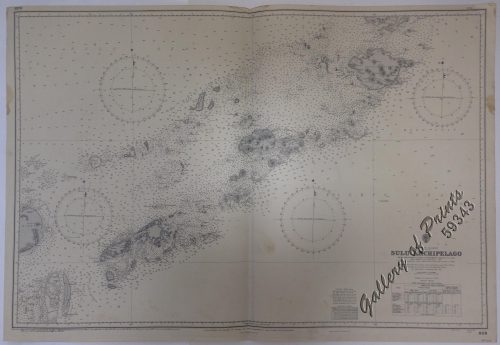
Philippine Islands. Sulu Archipelago. From the United States...
₱
11,000.00
Add to cart
Details
Plans in the Philippine Island. insets: 1) Luzon – Nor...
₱
11,000.00
Add to cart
Details
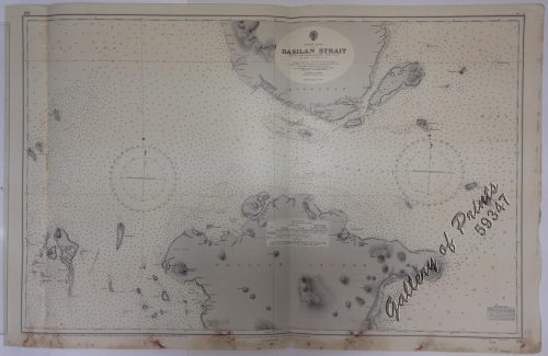
Philippine Islands. Basilan Strait. From the United States G...
₱
11,000.00
Add to cart
Details
Philippine Islands. Tagolo Point to Cuyo Islands. Including ...
₱
11,000.00
Add to cart
Details
Ports in the Philippine Islands. insets: 1) Luzon I. –...
₱
13,200.00
Add to cart
Details
1
2
Next
Shopping Cart
China Sea. Philippine Islands. San Bernardino Strait and Approaches. From the United States Coast Survey Charts to 1923. With Additions and corrections to 1934
1
Enciclopedia Hispano-Americana Manual de Barnices y Preparacion de Charoles segun los procederes mas recientes. [Manual of Varnishes and Preparation of Patent Leathers according to the most recent procedures.]
1
Interior of the Crater of the Volcano at Taal
1
The Story of the Philippines and our new Possessions
1
Zeocephus Cinnamomeus (Fig. 1) [Rufous Paradise Flycatcher] Z. Cyanescens (Fig. 2), pl.48 [Blue Paradise Flycatcher]
1
Plan of the Bay of Manilla in the Isle of Luconia, the Principal of the Philippine Islands, Surveyed by Señor Alexandro Malaspina and Communicated By Captn. G.G. Richardson.
1
Girls Bathing
1
Musa Coccinea. Andr. [Tagalog: Flowering Banana]
1
[Sailing Boat] [illegible title]
1
El Sitio de Manila (1898). Memorias de un voluntario
1
Perücken-Sumach. Fig. 1072. [Smoke-tree/PurpleSmoke bush]; Westindische Nierenfrucht. Fig. 1073. [West Indian Cashew Nut]; Aechter Mangobaum. Fig. 1074. [Genuine Mangotree]; Purpurrothe Mombinpflaume. Fig. 1075. [Purple Mobinplum]
1
1) Chrysocolaptes lucidus erythrocephalus [Red-faced Golden Woodpecker (male type specimen)]. 2) Chrysocolaptes lucidus maculiceps [Basilan Crimson-backed Woodpecker (type specimen young female)]
1
Philippine Islands. Samar and Leyte. San Juanico Strait and Approaches. From the United States Government Surveys to 1935. With Additions and Corrections from the Philippine Gov't. Charts to 1957. inset: 1) Northern Entrance to San Juanico Strait. From the United States Government Surveys of 1925. With Additions and Corrections from the Philippine Gov't. Charts to 1957.
1
The Manila Galleon
1
To U.S. Military Welcome to Manila and USO Club, Manila Hotel
1
[Luzon & Visayas]]
1
Codiaeum Variegatum. Rump. [English: Croton] [Local Names: San Francisco / Deliciosa]
1
Der Vulkan von Taal auf Luzon
1
Carte des Iles Philippines Pour servirà l'intelligence de l'ouvrage sur les Possessions Espagnoles dans l'Océanie, par Mr. J. Mallat. inset: Iles Batanes
1
Traubige Passionsblume. Fig. 921. [Grapy Passionflower]; Vierkantige Passionsblume. Fig. 922. [Tetragonal Passionflower]; Rothe Passionsblume. Fig. 923. [Red Passionflower]; Aepfeltragende Passionsblume. Fig. 924. [Apple-carrying Passionflower]; Carminrothe Passionsblume. Fig. 925 [Carmine-red Passionflower]
1
Gallicolumba keayi [Negros Puñalada]
1
The Murillo Bulletin, Journal of PHIMCOS, Special World War II Issue
1
Campagnard Tagal, pres de Manille (Iles Philippines.) [Tagalog Man from the Countryside near Manila]
1
Lost Islands : The Story of Islands That Have Vanished from Nautical Charts
1
China Sea - Palawan - East Coast - Port Royalist (P.to Princesa de Asturias of the Spanish). Surveyed by Comr. W.T. Bate R.N. Assisted by Lt C. Pasco, C. Bullock, Mate & W.B. Colver 2nd Master H.M.S/ Royalist 1850
1
Philippine Islands. Anchorages in Northern Luzon and the Babuyan Islands. Insets: 1) Babuyan Is. - Fuga I. Musa Bay. From the United States Government Chart to 1931. 2) Babuyan Is. - Camiguin I. Port San Pio Quinto. From the United States Government Chart to 1931. 3) Luzon-North-East Coast Port San Vicente. From the United States Government Chart to 1938. 4) Luzon - East Coast Mauban Anchorage. From the Philippine Government Chart of 1957. 5) Luzon - West Coast. Salomague Harbour and Lapog Bay. From the United States Government Chart of 1934. 6) Luzon - West Coast Port Currimao and Gan Bay. From the United States Government Chart of 1934. 7) Luzon - West Coast Solvec Cove. From the United States Government Chart of 1934. 8) Luzon - West Coast Lingayen Gulf. Port Sual with Cabalitian Bay. From the United States Government Chart of 1922. 9) Luzon - West Coast San Fernando Harbour. From the United States Government Chart of 1936.
1
Philippine Islands. Tablas Strait with Part of Sibuyan Sea. From the United States Government Charts of 1935.
1
A Boat Girl at Canton
1
Malaien der Insel Luzon [Malay of Luzon Island]
1
Lost at Sea. The strange route of the Lena Shoal junk
1
China Sea - Macclesfield Bank. Surveyed by Commander W.U. Moore and the Officers of H.M. Surveying Ship Penguin, 1892. and by Commander A. Mostyn Field and the Officers of H.M. Surveying Ship Egeria,1893.
1
Harper's Weekly - A Journal of Civilization with frontispiece: Ice-Yachting-Hard-A-Lee! Drawn by W. P. Snyder.
1
The Story of Maps. Putting the World in Perspective
1
Harper's Weekly - A Journal of Civilization with frontispiece: The Sovereigns at the with frontispiece: In The Bitter Cold.
1
Sticklebacks 1. Rough - tailed 2. Half - armed 3. Smooth - tailed 4. Short - spined 5. Four - spined 6. Ten - spined
1
Eene audiente bij den Sultan van Soeloe
1
[Emperor Moth]
1
Carayas ou machines a pecher et Banka de Manille. ["Tarayas" (correctly called "Salambas") or fishing contraptions; and "Banka" from Manila]
1
Memorias de la Real Academia de Ciencias Exactas, Fisicas y Naturales de Madrid Tomo XIV. - Atlas Estudios Preliminares Sobre La Fauna Malacológica de las Islas Filipinas.
1
Insulae Philippinae
1
Cart
Checkout
Continue Shopping
40