Tel : +63(2)-7729-8168
|
Email Us : gallery@gop.com.ph
My Account
Remember Me
Register
9 Item(s)
-
₱
420,600.00
Harper's Weekly - A Journal of Civilization with frontispiece: Ice-Yachting-Hard-A-Lee! Drawn by W. P. Snyder.
1 x
₱
7,700.00
Mapping the World: Maps and Their History
1 x
₱
5,500.00
Tahiti Girl Gathering Oranges.
1 x
₱
4,400.00
Ports in the Philippine Islands. insets: 1) Luzon I. - West Coast. Manila and Cavite Anchorages. From the United States Government Chart of 1950. with additions and corrections to 1969. 2) Luzon I. - West Coast. Manila Harbour. From the United States Government Chart of 1950. with additions and corrections to 1969.
1 x
₱
11,000.00
Fifty Shades of Philippine Art: Damián Domingo
1 x
₱
1,500.00
Discovering Antique Maps
1 x
₱
1,500.00
Pont de Manille [Manila Bridge]
1 x
₱
49,500.00
Campagnard Tagal, pres de Manille (Iles Philippines.) [Tagalog Man from the Countryside near Manila]
1 x
₱
290,000.00
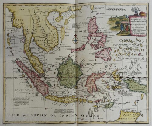
A New Map of the East Indies, Taken from Mr. de Fer's Map of Asia, Shewing their Chief Divisions, Cities, Towns, Ports, Rivers, Mountains & c. Dedicated to His Highness William Duke of Glocester.
1 x
₱
49,500.00
View Cart
Checkout
Home
About Us
Publications
Shop Online
Framing Services
Exhibits
Picture Hanging System
Contact Us
View cart
“A New Map of the East Indies, Taken from Mr. de Fer’s Map of Asia, Shewing their Chief Divisions, Cities, Towns, Ports, Rivers, Mountains & c. Dedicated to His Highness William Duke of Glocester.” has been added to your cart.
Sort by
Name
Sort by
Default Order
Sort by
Name
Sort by
Price
Sort by
Date
Sort by
Popularity
Show
30 Products
Show
30 Products
Show
60 Products
Show
90 Products
‘Luzon, West Coast – Port Santo Tomas – Li...
₱
2,200.00
Add to cart
Details
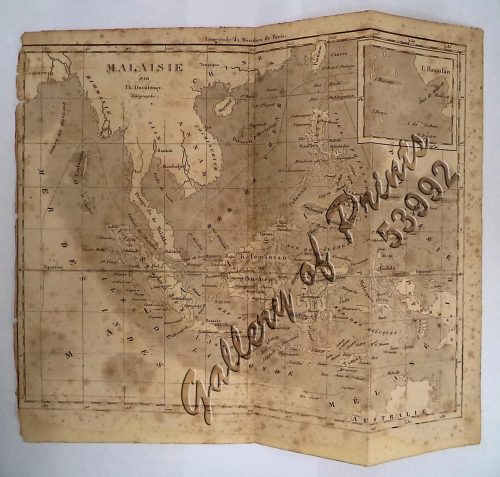
‘Malaisie. inset: I. Bassilan
₱
4,400.00
Add to cart
Details
‘XIV. Von Schanghai nach Guaham und Puynipet. [Carolin...
₱
3,300.00
Add to cart
Details
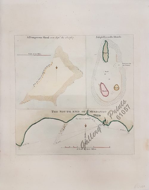
1) A Dangerous Shoal… 2) Joseph Freewills Island. 3) The S...
₱
13,500.00
Add to cart
Details
1) Carta dell’Isole Filippine [1st sheet]. 2) Carta de...
₱
61,600.00
Add to cart
Details
1) Carte des Isles Philippines (1e feuille) Kaart der Philip...
₱
77,000.00
Add to cart
Details
1) Isla de Paragua o Palawan Sur pl. 25 (Southern Palawan)
₱
7,700.00
Add to cart
Details
1) Islas Filipinas 1ª Hoja; 2) Islas Filipinas 2...
₱
39,600.00
Add to cart
Details
1) Islas Filipinas: Primera Hoja Central; 2) Islas Filipinas...
₱
99,000.00
Add to cart
Details
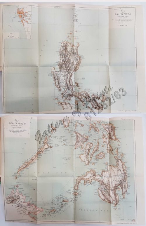
1) Karte der Philippinen (Nördliches Blatt), inset: Plan vo...
₱
39,600.00
Add to cart
Details
1) Mapa de las Islas Filipinas 2) Islas Carolinas 3) Islas...
₱
15,700.00
Add to cart
Details
1) Plan du port d’ Acapulco sur la Côte du Mexique da...
₱
26,400.00
Add to cart
Details
1) Plan of Solsogon Harbour on the South Coast of Luconia. 2...
₱
36,500.00
Add to cart
Details
1. Borneo. 2. The Philippine Islands.
₱
15,400.00
Add to cart
Details
1. Cap Blanc sur la Cote des Patagons,… Kaap Blanco aan de...
₱
4,400.00
Add to cart
Details
A Chart of the Channel in the Philipine Islands [sic] Throug...
₱
26,400.00
Add to cart
Details
A Chart of the Channel in the Phillippine Islands through wh...
₱
44,000.00
Add to cart
Details
A Chart of the Channel in the Phillippine [sic] Islands thro...
₱
39,600.00
Add to cart
Details
A Chart of the China Sea, and Philippine Islands, with the A...
₱
780,000.00
Add to cart
Details
A Chart of the Coast of China from Cambodia to Nanquam with ...
₱
155,000.00
Add to cart
Details
A Chart of the Pacific Ocean from the Equinoctial to the Lat...
₱
15,400.00
Add to cart
Details
A Chart of the Pelew Islands…
₱
39,600.00
Add to cart
Details
A Map of the East Indies from the latest Authorities and Obs...
₱
26,400.00
Add to cart
Details
A New and Accurate Map of the East India Islands
₱
56,100.00
Add to cart
Details
A New Map of the East Indies, Taken from Mr. de Fer’s ...
₱
49,500.00
Add to cart
Details
A New Map of the Philippine Islands, Drawn from the best Aut...
₱
49,500.00
Add to cart
Details
1
2
3
4
…
15
16
17
Next
Shopping Cart
A New Map of the East Indies, Taken from Mr. de Fer's Map of Asia, Shewing their Chief Divisions, Cities, Towns, Ports, Rivers, Mountains & c. Dedicated to His Highness William Duke of Glocester.
1
Campagnard Tagal, pres de Manille (Iles Philippines.) [Tagalog Man from the Countryside near Manila]
1
Pont de Manille [Manila Bridge]
1
Discovering Antique Maps
1
Fifty Shades of Philippine Art: Damián Domingo
1
Ports in the Philippine Islands. insets: 1) Luzon I. - West Coast. Manila and Cavite Anchorages. From the United States Government Chart of 1950. with additions and corrections to 1969. 2) Luzon I. - West Coast. Manila Harbour. From the United States Government Chart of 1950. with additions and corrections to 1969.
1
Tahiti Girl Gathering Oranges.
1
Mapping the World: Maps and Their History
1
Harper's Weekly - A Journal of Civilization with frontispiece: Ice-Yachting-Hard-A-Lee! Drawn by W. P. Snyder.
1
Cart
Checkout
Continue Shopping
9