Tel : +63(2)-7729-8168
|
Email Us : gallery@gop.com.ph
My Account
Remember Me
Register
11 Item(s)
-
₱
243,000.00
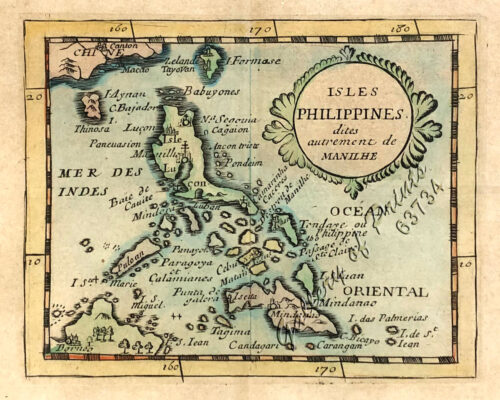
Isles Philippines dites autrement de Manilhe
1 x
₱
49,500.00
A view of Cape Espiritu Santo, on Samal, one of the Phillippine Islands… Centurion engag'd and took the Spanish Galeon call'd Nostra Seigniora de Cabadonga, from Acapulco bound to Manila.
1 x
₱
49,000.00
Pêcheurs dans riviere de Passit. [Fishermen on The Pasig River]
1 x
₱
39,600.00
Old Manila
1 x
₱
9,900.00
Mosque in the Town of Sooloo
1 x
₱
13,200.00
Prout's Microcosm Plate 11
1 x
₱
4,400.00
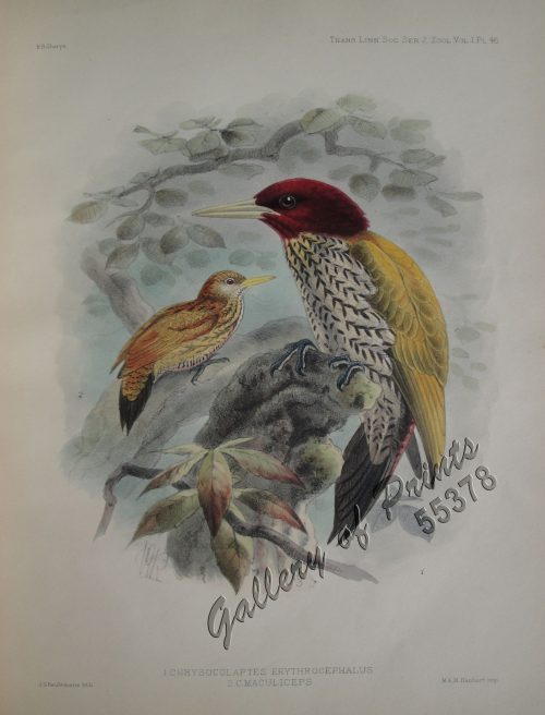
Chrysocolaptes Erythrocephalus (Fig. 1) [Crimson-backed Woodpecker] C. maculiceps (Fig. 2) pl.46
1 x
₱
22,000.00
French Consular Dispatches on the Philippine Revolution.
1 x
₱
1,100.00
Philippine Islands. Samar and Leyte. San Juanico Strait and Approaches. From the United States Government Surveys to 1935. With Additions and Corrections from the Philippine Gov't. Charts to 1957. inset: 1) Northern Entrance to San Juanico Strait. From the United States Government Surveys of 1925. With Additions and Corrections from the Philippine Gov't. Charts to 1957.
1 x
₱
11,000.00
Plan Du Port De Sorsogon,…
1 x
₱
39,600.00
The Charting of the Oceans; Ten Centuries of Maritime Maps
1 x
₱
3,700.00
View Cart
Checkout
Home
About Us
Publications
Shop Online
Framing Services
Exhibits
Picture Hanging System
Contact Us
View cart
“The Charting of the Oceans; Ten Centuries of Maritime Maps” has been added to your cart.
Sort by
Date
Sort by
Default Order
Sort by
Name
Sort by
Price
Sort by
Date
Sort by
Popularity
Show
30 Products
Show
30 Products
Show
60 Products
Show
90 Products
French Consular Dispatches on the Philippine Revolution.
₱
1,100.00
Add to cart
Details
China in Those Days. Insights into Historical China through ...
₱
7,700.00
Add to cart
Details
The Charting of the Oceans; Ten Centuries of Maritime Maps
₱
3,700.00
Add to cart
Details
Postcards
₱
990.00
Add to cart
Details
The Hakluyt Society. The Travels and Controversies of Friar ...
₱
6,600.00
Add to cart
Details
The Philippines in the 19th Century (A Collection of Prin...
₱
3,500.00
Add to cart
Details
Philippine Cartography
₱
6,600.00
Add to cart
Details
Previous
1
2
3
4
5
Shopping Cart
The Charting of the Oceans; Ten Centuries of Maritime Maps
1
Plan Du Port De Sorsogon,…
1
Philippine Islands. Samar and Leyte. San Juanico Strait and Approaches. From the United States Government Surveys to 1935. With Additions and Corrections from the Philippine Gov't. Charts to 1957. inset: 1) Northern Entrance to San Juanico Strait. From the United States Government Surveys of 1925. With Additions and Corrections from the Philippine Gov't. Charts to 1957.
1
French Consular Dispatches on the Philippine Revolution.
1
Chrysocolaptes Erythrocephalus (Fig. 1) [Crimson-backed Woodpecker] C. maculiceps (Fig. 2) pl.46
1
Prout's Microcosm Plate 11
1
Mosque in the Town of Sooloo
1
Old Manila
1
Pêcheurs dans riviere de Passit. [Fishermen on The Pasig River]
1
A view of Cape Espiritu Santo, on Samal, one of the Phillippine Islands… Centurion engag'd and took the Spanish Galeon call'd Nostra Seigniora de Cabadonga, from Acapulco bound to Manila.
1
Isles Philippines dites autrement de Manilhe
1
Cart
Checkout
Continue Shopping
11