Tel : +63(2)-7729-8168
|
Email Us : gallery@gop.com.ph
My Account
Remember Me
Register
28 Item(s)
-
₱
1,075,390.00
Mapa General Atlas Geografico Descriptivo de la Peninsula Ibérica Yslas Baleares, Canarias y posesiones Españolas de Ultramar por el Comandte Capn de Infa auxiliar que ha sido del Deposito de la Guerra D. Emilio Valverde Y Alvarez. [insets]: 1. Islas Filipinas 2. Posesiones Españolas de golfo del Guinea 3. Antillas Españolas 4. Islas Canarias
1 x
₱
17,700.00
Ports in the Philippine Islands. insets: 1) Luzon I. - West Coast. Manila and Cavite Anchorages. From the United States Government Chart of 1950. with additions and corrections to 1969. 2) Luzon I. - West Coast. Manila Harbour. From the United States Government Chart of 1950. with additions and corrections to 1969.
1 x
₱
11,000.00
Otophora Alata. Bl. [English: Johore Tree, Malaysian Lepisanthe], Perupoks
1 x
₱
26,400.00
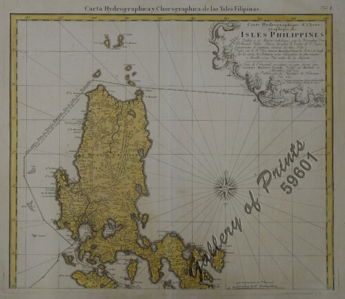
Carte Hydrographique & Chorographique des Isles Philippines (Carta Hydrographica y Chorographica de las Ysles Filipinas)
1 x
₱
425,000.00
The Murillo Bulletin, Journal of PHIMCOS, Issue No. 16
1 x
₱
790.00
Atlas of Military History. An Illustrated Global Survey of Warfare from Antiquity to the Present Day
1 x
₱
4,400.00
A View of the Entrance of the Port of Acapulco
1 x
₱
11,000.00
Zygænidæ - Syntomidæ. Fig. 1. Aglaope Infausta. Fig. 2, a,b. Ino Globulariæ. Fig. 3. Ino Statices. Fig. 4, a, b. Zygæna Minos. Fig. 5. Zygæna Scabiosæ. Fig. 6. Zygæna Achilleæ. Fig. 7, a, b, c. Zygæna Loniceræ. Fig. 8. Zygæna Trifolii. Fig. 9. Zygæna Meliloti. Fig. 10, a, b. Zygæna Filipendulæ. Fig. 11, a. Zygæna Ephialtes, variety Coronillæ. Fig. 11, b. Zygæna Ephialtes (type). Fig. 11, c. Zygæna Ephialtes, variety Peucedani. Fig. 12. Zygæna Carniolica. Fig. 13. Zygæna Fausta. Fig. 14. Zygæna Læta. Fig. 15. Syntomis Phegea. A. Common Bird's-foot Trefoil. [Lotus Corniculatus.]. B. Mountain Trefoil. [Trifolium Montanum.]. C. Bush Vetch. [Vicia Sepium.]. D. [Globularia Vulgaris.]
1 x
₱
3,300.00
Environs of Manila
1 x
₱
11,000.00
1. Panguingui (Card-playing) in Manilla; 2. Planting Rice in Manilla.
1 x
₱
7,700.00
Chart of Zamboanga
1 x
₱
4,400.00
Insulae Philippinae
1 x
₱
220,000.00
The Story of the Philippines and our new Possessions
1 x
₱
3,300.00
The Illustrated London News Vol. 36 - No. 1015
1 x
₱
6,600.00
Early Maps of South-East Asia
1 x
₱
5,500.00
Girls Bathing
1 x
₱
6,600.00
Reisen in den Philippinen [Travels in the Philippines] [with appendices: Ueber die geologische Beschaffenheit der Philippinen [On the Geological State of the Ph] Ueber alte und neue Schädel von den Philippinen [On Old and New Skulls of the Ph] with notes on the taxes etc.]
1 x
₱
99,000.00
The Cartography of the East Indian Islands, Insulae Indiae Orientalis.
1 x
₱
6,600.00
Waterfall of the Botocan (Laguna, Luzon)
1 x
₱
5,500.00
Cascos de la Laguna, a la voile. ["Cascos" from La Laguna, under Sail]
1 x
₱
99,000.00
Philippine Islands. Camotes Sea with Canigao Chanel. From the United States Government Charts to 1932. with corrections to 1934.
1 x
₱
11,000.00
Mittheilungen aus Justus Perthes' Geographischer Anstalt. über wichtige neue Erforschungen auf dem Gesammtgebiete der Geographie von Dr. A. Petermann. - Ergänzungsband VIII, 1873-74 Inhalt: [Supplement Vol. 8 contents] No. 35. Behm und Wagner, die Bevölkerung der Erde, II. No. 36. Dr. G. Radde, vier Vorträge über den Kaukasus. No. 37. Carl Mauch's Reisen im Innern von Süd-Afrika, 1865-72. No. 38. A. Wojeikof, die atmosphärische Circulation. Verbreitung des Luftdruckes, der Winde und der Regen auf der Oberfläche der Erde.
1 x
₱
6,000.00
The Philippine Journal of Science Vol. 1, No.8 The Non-Christian Tribes of Northern Luzon
1 x
₱
9,900.00
Eene audiente bij den Sultan van Soeloe
1 x
₱
11,000.00
El Marqués de Campo y la sucursal del Banco Peninsular Ultramarino establecida en Manila [The Marques de Campo and the branch of the Overseas Peninsular Bank established in Manila]
1 x
₱
8,800.00
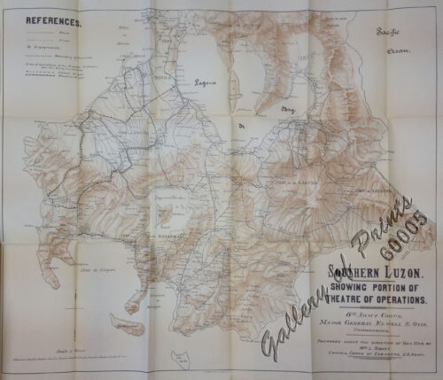
Southern Luzon. Showing portion of Theatre of Operations. 8th Army Corps, Major Gen. Elwell S. Otis, commanding. - Prepared under the direction of Gen. Otis by Wm L. Sibert, Captain, Corps of Engineers, U.S. Army.
1 x
₱
31,900.00
Philippine Islands. Samar and Leyte. San Juanico Strait and Approaches. From the United States Government Surveys to 1935. With Additions and Corrections from the Philippine Gov't. Charts to 1957. inset: 1) Northern Entrance to San Juanico Strait. From the United States Government Surveys of 1925. With Additions and Corrections from the Philippine Gov't. Charts to 1957.
1 x
₱
11,000.00
China Sea - Philippine Islands. San Bernardino Strait and Approaches. From the United States Coast Survey Charts to 1923. with additions and corrections to 1934.
1 x
₱
11,000.00
View Cart
Checkout
Home
About Us
Publications
Shop Online
Framing Services
Exhibits
Picture Hanging System
Contact Us
View cart
“China Sea – Philippine Islands. San Bernardino Strait and Approaches. From the United States Coast Survey Charts to 1923. with additions and corrections to 1934.” has been added to your cart.
Sort by
Default Order
Sort by
Default Order
Sort by
Name
Sort by
Price
Sort by
Date
Sort by
Popularity
Show
30 Products
Show
30 Products
Show
60 Products
Show
90 Products
China Sea – Macclesfield Bank. Surveyed by Commander W...
₱
6,600.00
Add to cart
Details
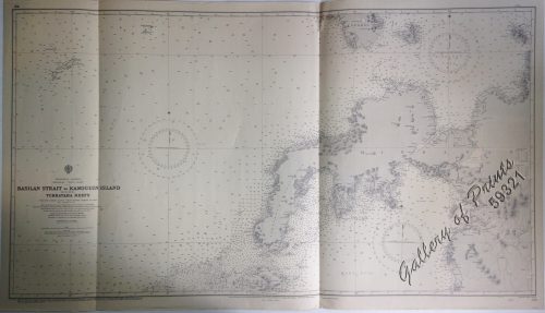
Philippine Islands Mindanao – West Coast – Basil...
₱
11,000.00
Add to cart
Details
Philippine Islands. Tagolo Point to Cuyo Islands. Including ...
₱
11,000.00
Add to cart
Details
Philippine Islands. Mindoro Strait. From the United States G...
₱
11,000.00
Add to cart
Details
Philippine Islands. Tablas Strait with Part of Sibuyan Sea. ...
₱
11,000.00
Add to cart
Details
Philippine Islands. Verde Island Passage. From the United St...
₱
11,000.00
Add to cart
Details
Philippine Islands. Samar and Leyte. San Juanico Strait and ...
₱
11,000.00
Add to cart
Details
Philippine Islands. The Passages Between Panay. Negros and C...
₱
11,000.00
Add to cart
Details
Philippine Islands. Cuyo East Pass. From the United States G...
₱
11,000.00
Add to cart
Details
Philippine Islands. Luzon Island. North of Latitude 16° 20...
₱
11,000.00
Add to cart
Details
Philippine Islands. Western Part of Mindanao Sea with Bohol ...
₱
11,000.00
Add to cart
Details
Philippine Islands. Sibuyan Sea to San Bernardino Strait. Fr...
₱
11,000.00
Add to cart
Details
Philippine Islands. Camotes Sea with Canigao Chanel. From th...
₱
11,000.00
Add to cart
Details
Philippine Islands. Leyte Gulf To Mayo Bay. Including Leyte,...
₱
11,000.00
Add to cart
Details
Philippine Islands. Mindoro and Adjacent Islands. Cuyo Is. T...
₱
11,000.00
Add to cart
Details
Philippine Islands. Luzon-West and East Coasts. Cabra I. to ...
₱
11,000.00
Add to cart
Details
Philippine Islands. Luzon Island. North of Latitude 16° 20...
₱
11,000.00
Add to cart
Details
Philippine Islands. Anchorages in Northern Luzon and the Bab...
₱
11,000.00
Add to cart
Details
Ports in the Philippine Islands. insets: 1) Luzon I. –...
₱
11,000.00
Add to cart
Details
China Sea – Philippine Islands. San Bernardino Strait ...
₱
11,000.00
Add to cart
Details
Philippine Islands. Surigao Srait with Leyte Gulf and Hinatu...
₱
11,000.00
Add to cart
Details
Anchorages of Luzon, Mindoro and Marinduque. insets: 1) Luzo...
₱
11,000.00
Add to cart
Details
China Sea. Philippine Islands. San Bernardino Strait and App...
₱
11,000.00
Add to cart
Details
Philippine Islands – Mindanao. Davao Gulf. From the Ph...
₱
11,000.00
Add to cart
Details
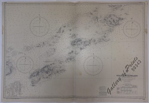
Philippine Islands. Sulu Archipelago. From the United States...
₱
11,000.00
Add to cart
Details
Plans in the Philippine Island. insets: 1) Luzon – Nor...
₱
11,000.00
Add to cart
Details
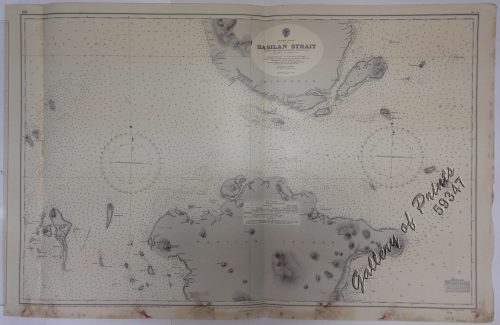
Philippine Islands. Basilan Strait. From the United States G...
₱
11,000.00
Add to cart
Details
Philippine Islands. Tagolo Point to Cuyo Islands. Including ...
₱
11,000.00
Add to cart
Details
Ports in the Philippine Islands. insets: 1) Luzon I. –...
₱
13,200.00
Add to cart
Details
1
2
Next
Shopping Cart
China Sea - Philippine Islands. San Bernardino Strait and Approaches. From the United States Coast Survey Charts to 1923. with additions and corrections to 1934.
1
Philippine Islands. Samar and Leyte. San Juanico Strait and Approaches. From the United States Government Surveys to 1935. With Additions and Corrections from the Philippine Gov't. Charts to 1957. inset: 1) Northern Entrance to San Juanico Strait. From the United States Government Surveys of 1925. With Additions and Corrections from the Philippine Gov't. Charts to 1957.
1
Southern Luzon. Showing portion of Theatre of Operations. 8th Army Corps, Major Gen. Elwell S. Otis, commanding. - Prepared under the direction of Gen. Otis by Wm L. Sibert, Captain, Corps of Engineers, U.S. Army.
1
El Marqués de Campo y la sucursal del Banco Peninsular Ultramarino establecida en Manila [The Marques de Campo and the branch of the Overseas Peninsular Bank established in Manila]
1
Eene audiente bij den Sultan van Soeloe
1
The Philippine Journal of Science Vol. 1, No.8 The Non-Christian Tribes of Northern Luzon
1
Mittheilungen aus Justus Perthes' Geographischer Anstalt. über wichtige neue Erforschungen auf dem Gesammtgebiete der Geographie von Dr. A. Petermann. - Ergänzungsband VIII, 1873-74 Inhalt: [Supplement Vol. 8 contents] No. 35. Behm und Wagner, die Bevölkerung der Erde, II. No. 36. Dr. G. Radde, vier Vorträge über den Kaukasus. No. 37. Carl Mauch's Reisen im Innern von Süd-Afrika, 1865-72. No. 38. A. Wojeikof, die atmosphärische Circulation. Verbreitung des Luftdruckes, der Winde und der Regen auf der Oberfläche der Erde.
1
Philippine Islands. Camotes Sea with Canigao Chanel. From the United States Government Charts to 1932. with corrections to 1934.
1
Cascos de la Laguna, a la voile. ["Cascos" from La Laguna, under Sail]
1
Waterfall of the Botocan (Laguna, Luzon)
1
The Cartography of the East Indian Islands, Insulae Indiae Orientalis.
1
Reisen in den Philippinen [Travels in the Philippines] [with appendices: Ueber die geologische Beschaffenheit der Philippinen [On the Geological State of the Ph] Ueber alte und neue Schädel von den Philippinen [On Old and New Skulls of the Ph] with notes on the taxes etc.]
1
Girls Bathing
1
Early Maps of South-East Asia
1
The Illustrated London News Vol. 36 - No. 1015
1
The Story of the Philippines and our new Possessions
1
Insulae Philippinae
1
Chart of Zamboanga
1
1. Panguingui (Card-playing) in Manilla; 2. Planting Rice in Manilla.
1
Environs of Manila
1
Zygænidæ - Syntomidæ. Fig. 1. Aglaope Infausta. Fig. 2, a,b. Ino Globulariæ. Fig. 3. Ino Statices. Fig. 4, a, b. Zygæna Minos. Fig. 5. Zygæna Scabiosæ. Fig. 6. Zygæna Achilleæ. Fig. 7, a, b, c. Zygæna Loniceræ. Fig. 8. Zygæna Trifolii. Fig. 9. Zygæna Meliloti. Fig. 10, a, b. Zygæna Filipendulæ. Fig. 11, a. Zygæna Ephialtes, variety Coronillæ. Fig. 11, b. Zygæna Ephialtes (type). Fig. 11, c. Zygæna Ephialtes, variety Peucedani. Fig. 12. Zygæna Carniolica. Fig. 13. Zygæna Fausta. Fig. 14. Zygæna Læta. Fig. 15. Syntomis Phegea. A. Common Bird's-foot Trefoil. [Lotus Corniculatus.]. B. Mountain Trefoil. [Trifolium Montanum.]. C. Bush Vetch. [Vicia Sepium.]. D. [Globularia Vulgaris.]
1
A View of the Entrance of the Port of Acapulco
1
Atlas of Military History. An Illustrated Global Survey of Warfare from Antiquity to the Present Day
1
The Murillo Bulletin, Journal of PHIMCOS, Issue No. 16
-
Quantity
+
Carte Hydrographique & Chorographique des Isles Philippines (Carta Hydrographica y Chorographica de las Ysles Filipinas)
1
Otophora Alata. Bl. [English: Johore Tree, Malaysian Lepisanthe], Perupoks
1
Ports in the Philippine Islands. insets: 1) Luzon I. - West Coast. Manila and Cavite Anchorages. From the United States Government Chart of 1950. with additions and corrections to 1969. 2) Luzon I. - West Coast. Manila Harbour. From the United States Government Chart of 1950. with additions and corrections to 1969.
1
Mapa General Atlas Geografico Descriptivo de la Peninsula Ibérica Yslas Baleares, Canarias y posesiones Españolas de Ultramar por el Comandte Capn de Infa auxiliar que ha sido del Deposito de la Guerra D. Emilio Valverde Y Alvarez. [insets]: 1. Islas Filipinas 2. Posesiones Españolas de golfo del Guinea 3. Antillas Españolas 4. Islas Canarias
1
Cart
Checkout
Continue Shopping
28