Tel : +63(2)-7729-8168
|
Email Us : gallery@gop.com.ph
My Account
Remember Me
Register
35 Item(s)
-
₱
1,686,000.00
A Chart of the China Sea, and Philippine Islands, with the Archipelagos of Felicia and Sooloo, shewing… …Canton and Balambangan,… composed from an original drawing, communicated by Capt. Robert Carr. and compared with the map of Pedro Murillo de Velarde, engraved at Manilla in 1734…. insets: 1) The Ports of Ylocos, on the West Coast of Luzon. 2) The Bay of Subic, on the West Coast of Luzon.
1 x
₱
780,000.00
España, Sus Monumento y Artes.... .....Cuba Puerto-Rico y Filipinas
1 x
₱
17,600.00
Fortsetzung der Karte von dem Morgenlændischen Ocean die Eylande Sonda die Küsten von Tunquin und China die Eylande Japon die Philippinischen und Molukkischen Eylande in sich enthaltend….1746 [Continuation of the Map of the Orient Ocean with the Sunda Islands, Tonkin and China, the islands of Japan, the Philippines and Molukkas…]
1 x
₱
46,600.00
Annual Reports of the War Department for the Fiscal Year Ended June 30, 1899. Report of the Major-General Commanding the Army. Part 2 [of 3]
1 x
₱
18,700.00
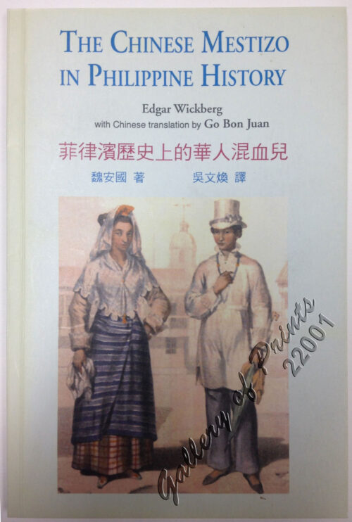
The Chinese Mestizo in Philippine History
1 x
₱
3,300.00
Nuestra prisión en poder de los revolucionarios filipinos. Crónica de dieciocho meses de cautiverio de más de cien religiosos del Centro de Luzón, empleados en el Ministerio de las Almas
1 x
₱
41,600.00
Carte de la Mer de Chine… par M. Daussy,… capitaine Horsburgh… Sous le Ministère de M. Ducampe De Rosamel… au Dépôt-Général de la Marine en 1838.
1 x
₱
166,000.00
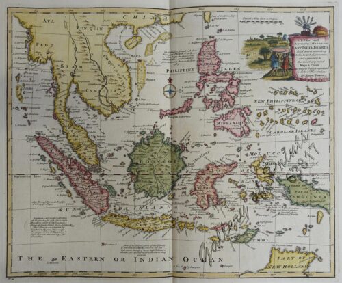
A New and Accurate Map of the East India Islands
1 x
₱
56,100.00
Marilandische Cassie. Fig. 1178. [Marylandian Cassie]; Rohrenfrüchtige Cassie. Fig. 1179. [Fruity rod-like Cassie]; Gemeiner Lokustbaum. Fig. 1180. [Common Locust tree]; Aegyptische Cassie. Fig. 1181. [Egyptian Cassie]
1 x
₱
5,500.00
Nieuwe Kaart van de Filippynsche, Ladrones, Moluccos of Specery Eilanden, als mede Celebes etc.
1 x
₱
34,000.00
Les Isles Philippines - Islas de los Ladrones... ou Isles des Larrons
1 x
₱
33,000.00
Islas de Infanta y Polillo pl. 12 [Quezon Prov., Polilio Is., Pananongan I., Jomalig I.]
1 x
₱
4,400.00
The War in Manila: Late views from the Front 1. Third Regiment Heavy Artillery in Line of Battle at Caloocan 2. Signaling at Caloocan 3. United Staes Tenst under Bamboo Thickets 4. In the Burned District in Manila 5. Dead Filipinos in their Trenches at Sta. Ana, near Manila 6. Commissary's Tent at Caloocan
1 x
₱
4,400.00
Plan du Port de Subec, en I'Isle de Lucon [Plan of The Port of Subic on Luzon Island]
1 x
₱
33,000.00
Philippine Islands. Verde Island Passage. From the United States Government Charts to 1933. With Additions and Corrections from Philippine Gov't. Charts to 1965 Soundings in upright hairline are from the Smaller Scale Charts.
1 x
₱
11,000.00
Schöne Costmurz. Fig. 307. [Beautiful Costmurz]; Cardamom-Elettarie. Fig. 308. [Cardamon-Elettarie]; Galgant-Alpinie. Fig. 309. [Galgant-Alpinia]; Paradies-Pisang. Fig. 310. [Paradise-Pisang][Banana]
1 x
₱
5,500.00
Carte des Indes et de la Chine…
1 x
₱
39,600.00
Terrain Handbook 41 Manila (Philippine Series)
1 x
₱
22,000.00
Asia wie es jetziger Zeit…
1 x
₱
49,500.00
Waterfall of the Botocan (Laguna, Luzon)
1 x
₱
5,500.00
1) Carta dell'Isole Filippine [1st sheet]. 2) Carta dell'Isole Filippine di Mr. Bellin Ingegnere della Marine Foglio 1 mo [2nd sheet]
1 x
₱
61,600.00
Ueber die Negritos oder Aetas der Philippinen. [Regarding the Negritos or Aetas of the Philippines]
1 x
₱
11,000.00
Ladmiral surmonte s'en allant au fond a nostre veúe
1 x
₱
49,600.00
[Indochina] Indien jenseits deß Ganges theilet sich: …
1 x
₱
31,900.00
The Peoples and Politics of the Far East : Travels and Studies
1 x
₱
11,000.00
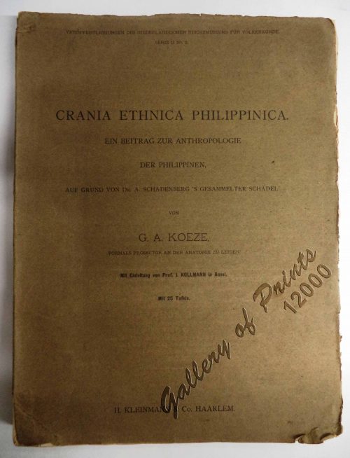
Crania Ethnica Philippinica. Ein Beitrag zur Anthropologie der Philippinen auf Grund von Dr. A. Schadenberg's gesammelter Scha[e]del [Dr. A. Schadenberrg's Collection of Skulls - Basis for a Controbution to Philippine Anthopology]
1 x
₱
13,200.00
A Filipino Street Band. A Scene in the Tondo Suburb of Manila.
1 x
₱
9,900.00
Archipel de Jolo
1 x
₱
3,300.00
Philippine Pagans. The Autographies of Three Ifugaos
1 x
₱
5,500.00
Carte du Canal des Isles Philippines par lequel passe le Galion de Manille et les Iles voisines de ce Canal [A Chart of the Channel in the Philippine Islands Through which the Manila Galeon passes, and the Islands Visible in that Channel]
1 x
₱
33,000.00
Doldentraubige Bauhinie. Fig. 1182. [Raceme bauhinia]; Scharlachrothe Brownea. Fig. 1183. [Scarlet Brownea]; Bohnenförmige Dickhütse. Fig. 1184 [Bean-shaped thickhut]; Prächtige Schotie. Fig. 1185. [Magnificent Shotty]; Martius'scher Lokustbaum. Fig. 1185. [Martiusian locust tree]
1 x
₱
5,500.00
Mittheilungen aus Justus Perthes' Geographischer Anstalt über Wichtige neue Erforschungen auf dem Gesammtgebiete der Geographie von Dr. A. Petermann. - Ergänzungsband I, 1860 u. 1861. Inhalt: [Supplement Vol. 1 contents] No. 1. A. Vibe, Küsten and Meer Norwegens. No. 2. J. J. v. Tschudi, Reise durch die Andes von Sud- Amerika, 1858. No. 3. Dr. H. Barth, Reise durch Kleinasien, 1858. No. 4. G. Lejean, Ethnographie de Europäischen Türkei, mit französischem und deutschem Text. No. 5. Dr. Moritz Wagner, Physisch - geographische Skizze des Isthmus von Panama. No. 6. Petermann und Hassenstein, Ost - Afrika zwischen Chartum, Sauakin and Massaua.
1 x
₱
8,600.00
East India Archipelago [Eastern Passages to China and Japan][Chart No.5] London, Published by James Imray and Son, 89 & 89a Minories, 1898
1 x
₱
36,000.00
To His Majesty George the Third, King of Great Britain & This Chart of Felicia and Plan of the Island Balambangan is humbly prefented by His Majesty's faithful Subject, Dalrymple - [Southern Palawan]
1 x
₱
26,400.00
Engagement of March 7, 1899 [Near San Pedro Macati, Luzon
1 x
₱
2,200.00
View Cart
Checkout
Home
About Us
Publications
Shop Online
Framing Services
Exhibits
Picture Hanging System
Contact Us
View cart
“Engagement of March 7, 1899 [Near San Pedro Macati, Luzon” has been added to your cart.
Sort by
Date
Sort by
Default Order
Sort by
Name
Sort by
Price
Sort by
Date
Sort by
Popularity
Show
30 Products
Show
30 Products
Show
60 Products
Show
90 Products
A Map of the East Indies from the latest Authorities and Obs...
₱
26,400.00
Add to cart
Details
The Philippine Islands. with inset – Manila Bay
₱
4,400.00
Add to cart
Details
Manille (pl.112)
₱
5,500.00
Add to cart
Details
Philippijnsche Eilanden.
₱
7,700.00
Add to cart
Details
East Indies from the best authorities
₱
6,600.00
Add to cart
Details
Chart of the East India Islands…
₱
6,600.00
Add to cart
Details
Carte du Theatre de la Guerre Hispano – Americaine [Ma...
₱
4,400.00
Add to cart
Details
Sketch of Combat at Trench Near Marilao. March 27th
₱
4,400.00
Add to cart
Details
Engagement of March 7, 1899 [Near San Pedro Macati, Luzon
₱
2,200.00
Add to cart
Details
Fort Ganassi Near Lake Lanao, Mindanao
₱
2,200.00
Add to cart
Details
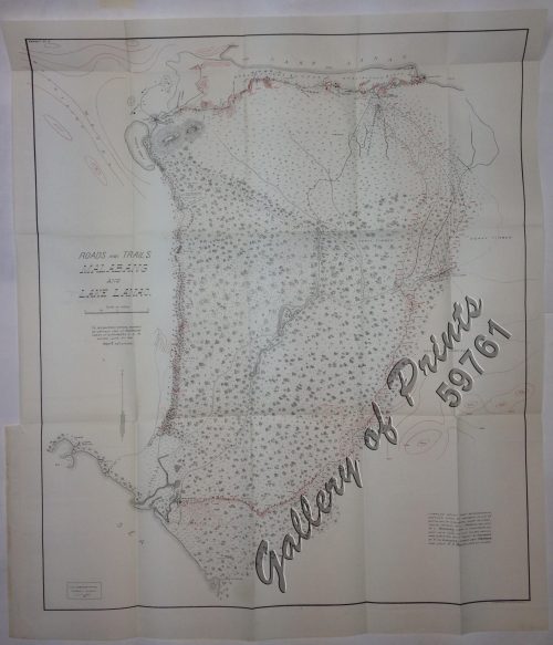
Roads and Trails Malabang and Lake Lanao.
₱
5,500.00
Add to cart
Details
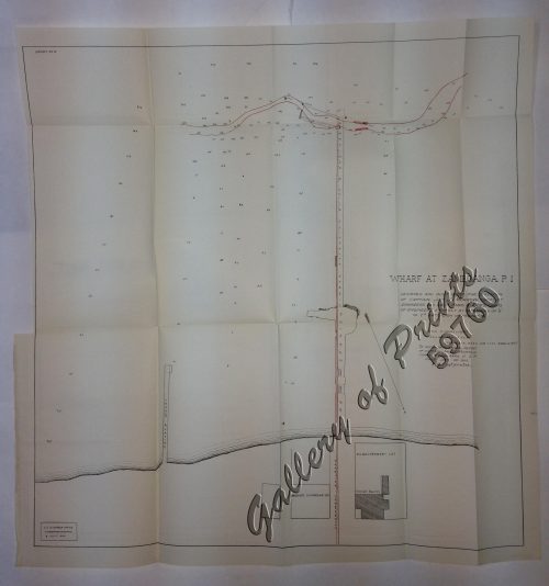
Wharf at Zamboanga P.I.
₱
5,500.00
Add to cart
Details
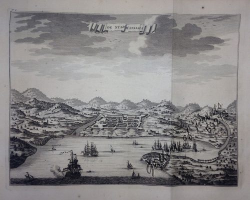
De Stad Manilha
₱
61,600.00
Add to cart
Details
Manilhas Bay [untitled chart of Manila Bay]
₱
36,500.00
Add to cart
Details
Southern Suburbs of the City of Manila and Vicinity, includi...
₱
4,400.00
Add to cart
Details
Previous
1
2
3
…
16
17
18
19
20
21
22
Next
Shopping Cart
Engagement of March 7, 1899 [Near San Pedro Macati, Luzon
1
To His Majesty George the Third, King of Great Britain & This Chart of Felicia and Plan of the Island Balambangan is humbly prefented by His Majesty's faithful Subject, Dalrymple - [Southern Palawan]
1
East India Archipelago [Eastern Passages to China and Japan][Chart No.5] London, Published by James Imray and Son, 89 & 89a Minories, 1898
1
Mittheilungen aus Justus Perthes' Geographischer Anstalt über Wichtige neue Erforschungen auf dem Gesammtgebiete der Geographie von Dr. A. Petermann. - Ergänzungsband I, 1860 u. 1861. Inhalt: [Supplement Vol. 1 contents] No. 1. A. Vibe, Küsten and Meer Norwegens. No. 2. J. J. v. Tschudi, Reise durch die Andes von Sud- Amerika, 1858. No. 3. Dr. H. Barth, Reise durch Kleinasien, 1858. No. 4. G. Lejean, Ethnographie de Europäischen Türkei, mit französischem und deutschem Text. No. 5. Dr. Moritz Wagner, Physisch - geographische Skizze des Isthmus von Panama. No. 6. Petermann und Hassenstein, Ost - Afrika zwischen Chartum, Sauakin and Massaua.
1
Doldentraubige Bauhinie. Fig. 1182. [Raceme bauhinia]; Scharlachrothe Brownea. Fig. 1183. [Scarlet Brownea]; Bohnenförmige Dickhütse. Fig. 1184 [Bean-shaped thickhut]; Prächtige Schotie. Fig. 1185. [Magnificent Shotty]; Martius'scher Lokustbaum. Fig. 1185. [Martiusian locust tree]
1
Carte du Canal des Isles Philippines par lequel passe le Galion de Manille et les Iles voisines de ce Canal [A Chart of the Channel in the Philippine Islands Through which the Manila Galeon passes, and the Islands Visible in that Channel]
1
Philippine Pagans. The Autographies of Three Ifugaos
1
Archipel de Jolo
1
A Filipino Street Band. A Scene in the Tondo Suburb of Manila.
1
Crania Ethnica Philippinica. Ein Beitrag zur Anthropologie der Philippinen auf Grund von Dr. A. Schadenberg's gesammelter Scha[e]del [Dr. A. Schadenberrg's Collection of Skulls - Basis for a Controbution to Philippine Anthopology]
1
The Peoples and Politics of the Far East : Travels and Studies
1
[Indochina] Indien jenseits deß Ganges theilet sich: …
1
Ladmiral surmonte s'en allant au fond a nostre veúe
1
Ueber die Negritos oder Aetas der Philippinen. [Regarding the Negritos or Aetas of the Philippines]
1
1) Carta dell'Isole Filippine [1st sheet]. 2) Carta dell'Isole Filippine di Mr. Bellin Ingegnere della Marine Foglio 1 mo [2nd sheet]
1
Waterfall of the Botocan (Laguna, Luzon)
1
Asia wie es jetziger Zeit…
1
Terrain Handbook 41 Manila (Philippine Series)
1
Carte des Indes et de la Chine…
1
Schöne Costmurz. Fig. 307. [Beautiful Costmurz]; Cardamom-Elettarie. Fig. 308. [Cardamon-Elettarie]; Galgant-Alpinie. Fig. 309. [Galgant-Alpinia]; Paradies-Pisang. Fig. 310. [Paradise-Pisang][Banana]
1
Philippine Islands. Verde Island Passage. From the United States Government Charts to 1933. With Additions and Corrections from Philippine Gov't. Charts to 1965 Soundings in upright hairline are from the Smaller Scale Charts.
1
Plan du Port de Subec, en I'Isle de Lucon [Plan of The Port of Subic on Luzon Island]
1
The War in Manila: Late views from the Front 1. Third Regiment Heavy Artillery in Line of Battle at Caloocan 2. Signaling at Caloocan 3. United Staes Tenst under Bamboo Thickets 4. In the Burned District in Manila 5. Dead Filipinos in their Trenches at Sta. Ana, near Manila 6. Commissary's Tent at Caloocan
1
Islas de Infanta y Polillo pl. 12 [Quezon Prov., Polilio Is., Pananongan I., Jomalig I.]
1
Les Isles Philippines - Islas de los Ladrones... ou Isles des Larrons
1
Nieuwe Kaart van de Filippynsche, Ladrones, Moluccos of Specery Eilanden, als mede Celebes etc.
1
Marilandische Cassie. Fig. 1178. [Marylandian Cassie]; Rohrenfrüchtige Cassie. Fig. 1179. [Fruity rod-like Cassie]; Gemeiner Lokustbaum. Fig. 1180. [Common Locust tree]; Aegyptische Cassie. Fig. 1181. [Egyptian Cassie]
1
A New and Accurate Map of the East India Islands
1
Carte de la Mer de Chine… par M. Daussy,… capitaine Horsburgh… Sous le Ministère de M. Ducampe De Rosamel… au Dépôt-Général de la Marine en 1838.
1
Nuestra prisión en poder de los revolucionarios filipinos. Crónica de dieciocho meses de cautiverio de más de cien religiosos del Centro de Luzón, empleados en el Ministerio de las Almas
1
The Chinese Mestizo in Philippine History
1
Annual Reports of the War Department for the Fiscal Year Ended June 30, 1899. Report of the Major-General Commanding the Army. Part 2 [of 3]
1
Fortsetzung der Karte von dem Morgenlændischen Ocean die Eylande Sonda die Küsten von Tunquin und China die Eylande Japon die Philippinischen und Molukkischen Eylande in sich enthaltend….1746 [Continuation of the Map of the Orient Ocean with the Sunda Islands, Tonkin and China, the islands of Japan, the Philippines and Molukkas…]
1
España, Sus Monumento y Artes.... .....Cuba Puerto-Rico y Filipinas
1
A Chart of the China Sea, and Philippine Islands, with the Archipelagos of Felicia and Sooloo, shewing… …Canton and Balambangan,… composed from an original drawing, communicated by Capt. Robert Carr. and compared with the map of Pedro Murillo de Velarde, engraved at Manilla in 1734…. insets: 1) The Ports of Ylocos, on the West Coast of Luzon. 2) The Bay of Subic, on the West Coast of Luzon.
1
Cart
Checkout
Continue Shopping
35