Tel : +63(2)-7729-8168
|
Email Us : gallery@gop.com.ph
My Account
Remember Me
Register
7 Item(s)
-
₱
141,300.00
Plan de La Baie de Manille
1 x
₱
39,600.00
Albay (Islas Filipinas). - Panorama de la Monataña y peligroso Volcan del mayon. (De un dibujo del natural.)
1 x
₱
6,600.00
Die Chinesen, Japaner und Inder auf den Philippinen [The Chinese, Japanese, and Indians in the Philippines]
1 x
₱
2,500.00
Mapa General Atlas Geografico Descriptivo de la Peninsula Ibérica Yslas Baleares, Canarias y posesiones Españolas de Ultramar por el Comandte Capn de Infa auxiliar que ha sido del Deposito de la Guerra D. Emilio Valverde Y Alvarez. [insets]: 1. Islas Filipinas 2. Posesiones Españolas de golfo del Guinea 3. Antillas Españolas 4. Islas Canarias
1 x
₱
17,700.00
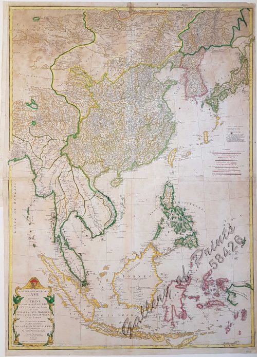
Seconde partie de la Carte d'Asie contenant la Chine et partie de la Tartarie, l'Inde au delà du Gange, les Isles Sumatra, Java, Borneo, Moluques, Philippines, et du Japon.
1 x
₱
39,600.00
Nachrichten von den Pelew-Inseln -in der Westgegend des Stillen Ozeans [An Account of the Pelew Islands, Situated in the Western Part of the Pacific Ocean]
1 x
₱
2,200.00
Map of the United States showing the Territorial Expansion of a Century 1804 to 1904 insets: 1) The World. 2) Wake Island. 3) Territory of Alaska. 4) Guam Island. 5) Porto Rico. 6) Philippine Islands. 7) Hawaiian Islands. 8) Tutuila, Manua and Smaller Islands of the Samoan Group. 9) Plan of Panama Canal Zone. 10) Plan showing the Thirteen Original States.
1 x
₱
33,100.00
View Cart
Checkout
Home
About Us
Publications
Shop Online
Framing Services
Exhibits
Picture Hanging System
Contact Us
Sort by
Date
Sort by
Default Order
Sort by
Name
Sort by
Price
Sort by
Date
Sort by
Popularity
Show
30 Products
Show
30 Products
Show
60 Products
Show
90 Products
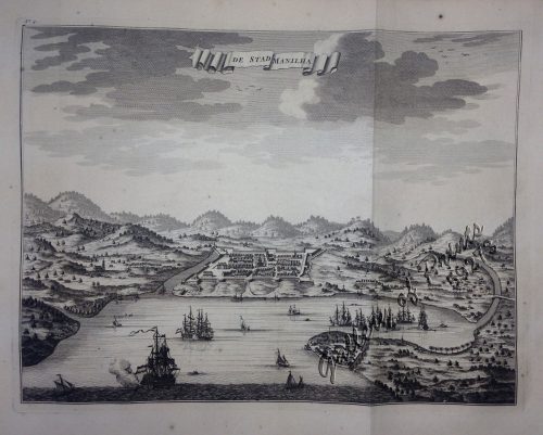
De Stad Manilha
₱
61,600.00
Add to cart
Details
Manilhas Bay [untitled chart of Manila Bay]
₱
36,500.00
Add to cart
Details
Southern Suburbs of the City of Manila and Vicinity, includi...
₱
4,400.00
Add to cart
Details
Santa Cruz Harbor [Marinduque]
₱
2,200.00
Add to cart
Details
Chart of the Coasts of America & Asia from California to...
₱
9,900.00
Add to cart
Details
Kanton und Kantonstrom (Canton & the River Canton)
₱
2,200.00
Add to cart
Details
[Sketch of the Area Between San Nicolas to Bambang]
₱
2,200.00
Add to cart
Details
Erster Entwurf zu einer Geologischen Uebersichts-Karte von S...
₱
22,000.00
Add to cart
Details
‘Luzon, West Coast – Port Santo Tomas – Li...
₱
2,200.00
Add to cart
Details
Malaiischer Archipel. insets: 1. Java, 2. Mittel – Luz...
₱
5,500.00
Add to cart
Details
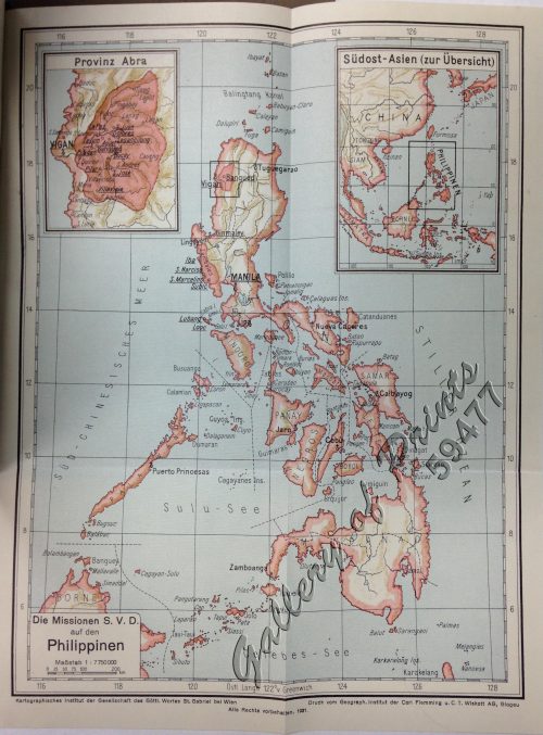
Die Missionen S.V.D auf den Philippinen. [insets:] [1] Provi...
₱
5,500.00
Add to cart
Details
Die Vulcane auf Luzon.
₱
11,000.00
Add to cart
Details
Manille – Die Stadt Manille [reverse picture] [City of...
₱
22,000.00
Add to cart
Details
Campaña de Filipinas
₱
49,500.00
Add to cart
Details
Islas Filipinas – Mapa General pl. 2, Observatorio d...
₱
5,500.00
Add to cart
Details
Islas Filipinas. – Grupo de Luzon. inset: [Batanes and...
₱
11,000.00
Add to cart
Details
Les Isles Philippines Molucques et de La Sonde Les Isles du ...
₱
26,400.00
Add to cart
Details
Philippine Islands. Tablas Strait with Part of Sibuyan Sea�...
₱
6,600.00
Add to cart
Details
Carte des Indes Orientales… (1e et 2e feuille)
₱
99,000.00
Add to cart
Details
Islas Filipinas
₱
39,600.00
Add to cart
Details
Carte d’ Espagne et des principaux etats appartments a...
₱
39,600.00
Add to cart
Details
Previous
1
2
3
…
13
14
15
16
17
Next
Shopping Cart
Map of the United States showing the Territorial Expansion of a Century 1804 to 1904 insets: 1) The World. 2) Wake Island. 3) Territory of Alaska. 4) Guam Island. 5) Porto Rico. 6) Philippine Islands. 7) Hawaiian Islands. 8) Tutuila, Manua and Smaller Islands of the Samoan Group. 9) Plan of Panama Canal Zone. 10) Plan showing the Thirteen Original States.
1
Nachrichten von den Pelew-Inseln -in der Westgegend des Stillen Ozeans [An Account of the Pelew Islands, Situated in the Western Part of the Pacific Ocean]
1
Seconde partie de la Carte d'Asie contenant la Chine et partie de la Tartarie, l'Inde au delà du Gange, les Isles Sumatra, Java, Borneo, Moluques, Philippines, et du Japon.
1
Mapa General Atlas Geografico Descriptivo de la Peninsula Ibérica Yslas Baleares, Canarias y posesiones Españolas de Ultramar por el Comandte Capn de Infa auxiliar que ha sido del Deposito de la Guerra D. Emilio Valverde Y Alvarez. [insets]: 1. Islas Filipinas 2. Posesiones Españolas de golfo del Guinea 3. Antillas Españolas 4. Islas Canarias
1
Die Chinesen, Japaner und Inder auf den Philippinen [The Chinese, Japanese, and Indians in the Philippines]
1
Albay (Islas Filipinas). - Panorama de la Monataña y peligroso Volcan del mayon. (De un dibujo del natural.)
1
Plan de La Baie de Manille
1
Cart
Checkout
Continue Shopping
7