Tel : +63(2)-7729-8168 | Mobile: +63 917 806 4291
|
Email: gallery@gop.com.ph
My Account
Remember Me
Register
13 Item(s)
-
₱
215,000.00
Manilla Water-Carrier.
1 x
₱
5,500.00
Les Isles Philippines et celles des Larrons… [with original text page]
1 x
₱
30,900.00
Japan A Cartographic Vision
1 x
₱
4,400.00
Report on the Geology of the Philippine Islands… Ueber tertiäre Fossilien von den Philippinen (1895) [Concerning Tertiary Fossils in the Philippines]
1 x
₱
7,700.00
Plan de La Baie de Manille
1 x
₱
39,600.00
Documents Illustrating the British Conquest of Manila 1762-1763
1 x
₱
3,700.00
Karte des südlichen Theiles von Luzon und benachbarter Inseln auf Grundlage der Coello'schen [Map of Southern Luzon and Adjacent Islands Based on Coello's Map]. insets: 1. Untere Fortsetzung [Lower Continuation]. 2. Übersichtskarte der Philippinen [Map of the Philippines]. . Die Kieselbrunnen Naglegbeng bei Tibi in Prov. Albáy [Paved Wells Neglegbeng near Tiwi in Albay Province]
1 x
₱
77,000.00
Le Pic verd de l'Isle de Luçon. [The Green Woodpecker in the Island of Luzon]
1 x
₱
6,600.00
Dalea Bicolor [Silver Prarie Clover]
1 x
₱
5,500.00
Sketches from Manilla and Hongkong. 1. "Soiree Musicale" at Manilla; 2. Chinese Nursemaid on the Parade- Ground, Hongkong
1 x
₱
9,900.00
Plan De La Baie De Bongo.
1 x
₱
6,600.00
Philippine Islands. Anchorages in Northern Luzon and the Babuyan Islands. Insets: 1) Babuyan Is. - Fuga I. Musa Bay. From the United States Government Chart to 1931. 2) Babuyan Is. - Camiguin I. Port San Pio Quinto. From the United States Government Chart to 1931. 3) Luzon-North-East Coast Port San Vicente. From the United States Government Chart to 1938. 4) Luzon - East Coast Mauban Anchorage. From the Philippine Government Chart of 1957. 5) Luzon - West Coast. Salomague Harbour and Lapog Bay. From the United States Government Chart of 1934. 6) Luzon - West Coast Port Currimao and Gan Bay. From the United States Government Chart of 1934. 7) Luzon - West Coast Solvec Cove. From the United States Government Chart of 1934. 8) Luzon - West Coast Lingayen Gulf. Port Sual with Cabalitian Bay. From the United States Government Chart of 1922. 9) Luzon - West Coast San Fernando Harbour. From the United States Government Chart of 1936.
1 x
₱
11,000.00
The Far East Compiled and Drawn in the Cartographic Section of the National Geographic Society for The National Geographic Magazine inset: Korea
1 x
₱
6,600.00
View Cart
Checkout
Home
About Us
Publications
Shop Online
Framing Services
Exhibits
Picture Hanging System
Contact Us
Blogs
View cart
“The Far East Compiled and Drawn in the Cartographic Section of the National Geographic Society for The National Geographic Magazine inset: Korea” has been added to your cart.
Sort by
Date
Sort by
Default Order
Sort by
Name
Sort by
Price
Sort by
Date
Sort by
Popularity
Show
30 Products
Show
30 Products
Show
60 Products
Show
90 Products
Philippine Religious – Carvings in Ivory
₱
2,500.00
Add to cart
Details
The Far East Compiled and Drawn in the Cartographic Section ...
₱
6,600.00
Add to cart
Details
Karte der St. Gotthard-Bahn, Taf.2 [Map of The Gotthard-Rail...
₱
5,280.00
Add to cart
Details
The National Geographic Magazine September, 1952, vol. CII, ...
₱
1,100.00
Add to cart
Details
The Manila-Acapulco Galleons: The Treasure Ships of the Paci...
₱
4,400.00
Add to cart
Details
Spanish Galleon 1530 – 1690 New Vanguard # 96
₱
2,200.00
Add to cart
Details
When Britain Ruled the Philippines 1762-1764
₱
2,200.00
Add to cart
Details
Iloilo A Rich and Noble Land
₱
7,500.00
Add to cart
Details
The Mysteries of Taal: A Philippine Volcano and Lake, Her S...
₱
900.00
Add to cart
Details
Northern Island New Zealand
₱
4,400.00
Add to cart
Details
South Island New Zealand
₱
4,400.00
Add to cart
Details
Map of Pacific Ocean by Robinson H. E. C. Pty. Ltd. Mercat...
₱
14,700.00
Add to cart
Details
Zambales
₱
17,600.00
Add to cart
Details
Leyte
₱
17,600.00
Add to cart
Details
Bohol
₱
17,600.00
Add to cart
Details
Rizal
₱
17,600.00
Add to cart
Details
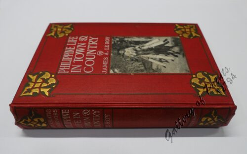
Philippine Life in Town & Country.
₱
8,800.00
Add to cart
Details
Philippines
₱
8,800.00
Add to cart
Details
The Mapping of the Heavens
₱
1,980.00
Add to cart
Details
Manila Harbor Complimentary Map of the City of Manila
₱
22,000.00
Add to cart
Details
Previous
1
2
3
…
60
61
62
63
Shopping Cart
The Far East Compiled and Drawn in the Cartographic Section of the National Geographic Society for The National Geographic Magazine inset: Korea
1
Philippine Islands. Anchorages in Northern Luzon and the Babuyan Islands. Insets: 1) Babuyan Is. - Fuga I. Musa Bay. From the United States Government Chart to 1931. 2) Babuyan Is. - Camiguin I. Port San Pio Quinto. From the United States Government Chart to 1931. 3) Luzon-North-East Coast Port San Vicente. From the United States Government Chart to 1938. 4) Luzon - East Coast Mauban Anchorage. From the Philippine Government Chart of 1957. 5) Luzon - West Coast. Salomague Harbour and Lapog Bay. From the United States Government Chart of 1934. 6) Luzon - West Coast Port Currimao and Gan Bay. From the United States Government Chart of 1934. 7) Luzon - West Coast Solvec Cove. From the United States Government Chart of 1934. 8) Luzon - West Coast Lingayen Gulf. Port Sual with Cabalitian Bay. From the United States Government Chart of 1922. 9) Luzon - West Coast San Fernando Harbour. From the United States Government Chart of 1936.
1
Plan De La Baie De Bongo.
1
Sketches from Manilla and Hongkong. 1. "Soiree Musicale" at Manilla; 2. Chinese Nursemaid on the Parade- Ground, Hongkong
1
Dalea Bicolor [Silver Prarie Clover]
1
Le Pic verd de l'Isle de Luçon. [The Green Woodpecker in the Island of Luzon]
1
Karte des südlichen Theiles von Luzon und benachbarter Inseln auf Grundlage der Coello'schen [Map of Southern Luzon and Adjacent Islands Based on Coello's Map]. insets: 1. Untere Fortsetzung [Lower Continuation]. 2. Übersichtskarte der Philippinen [Map of the Philippines]. . Die Kieselbrunnen Naglegbeng bei Tibi in Prov. Albáy [Paved Wells Neglegbeng near Tiwi in Albay Province]
1
Documents Illustrating the British Conquest of Manila 1762-1763
1
Plan de La Baie de Manille
1
Report on the Geology of the Philippine Islands… Ueber tertiäre Fossilien von den Philippinen (1895) [Concerning Tertiary Fossils in the Philippines]
1
Japan A Cartographic Vision
1
Les Isles Philippines et celles des Larrons… [with original text page]
1
Manilla Water-Carrier.
1
Cart
Checkout
Continue Shopping
13