Tel : +63(2)-7729-8168 | Mobile: +63 917 806 4291
|
Email: gallery@gop.com.ph
My Account
Remember Me
Register
22 Item(s)
-
₱
1,307,180.00
Pacifico - Islas Filipinas pl. 1
1 x
₱
6,600.00
1) Islas Filipinas: Primera Hoja Central; 2) Islas Filipinas: Segunda Hoja Central; 3) Posesiones de Ultramar (Oceania) - Islas Filipinas
1 x
₱
99,000.00
American President Lines. 1949 Dinner Menu.
1 x
₱
6,600.00
Pinus Taeda?- Blanco. Pinus Insularis: Endl.- Llanos - DC. [Local Name: Baguio Pine]
1 x
₱
39,600.00
Chætodon Imperator [Emperor Angelfish] Der Kaiserfisch. L'Empereur du Japon.
1 x
₱
4,400.00
Vue de l'ile de Romero sur le Pasig [View of Romero Island on the Pasig]
1 x
₱
2,200.00
Filipinas, lám.I Filipinas
1 x
₱
6,600.00
Atlas Minor ex Tabulis Geographicis…
1 x
₱
3,300.00
Diccionario Enciclopédico Hispano-Americano de Literatura, Ciencias y Artes. Tomo Octavo. "F-FYT" [Spanish-American Encyclopedic Dictionary of Literature, Sciences and Arts] [volume 8]
1 x
₱
14,700.00
Environs de Sincapour
1 x
₱
25,200.00
Philippine Islands. Anchorages in Northern Luzon and the Babuyan Islands. Insets: 1) Babuyan Is. - Fuga I. Musa Bay. From the United States Government Chart to 1931. 2) Babuyan Is. - Camiguin I. Port San Pio Quinto. From the United States Government Chart to 1931. 3) Luzon-North-East Coast Port San Vicente. From the United States Government Chart to 1938. 4) Luzon - East Coast Mauban Anchorage. From the Philippine Government Chart of 1957. 5) Luzon - West Coast. Salomague Harbour and Lapog Bay. From the United States Government Chart of 1934. 6) Luzon - West Coast Port Currimao and Gan Bay. From the United States Government Chart of 1934. 7) Luzon - West Coast Solvec Cove. From the United States Government Chart of 1934. 8) Luzon - West Coast Lingayen Gulf. Port Sual with Cabalitian Bay. From the United States Government Chart of 1922. 9) Luzon - West Coast San Fernando Harbour. From the United States Government Chart of 1936.
1 x
₱
11,000.00
Reduzirte Karte von den Philippinen und den Sulu Inseln [Reduced Map of the Philippines and the Sulu Islands] {insets:}. inset 1: Plan von der Bucht von Manila [Plan of Manila Bay]. inset 2: Islas Batanes. inset 3: Die Nordseite des Mindoro Kan. mit dem Volcan de Taal [Northern Mindoro Channel with Taal Volcano]. inset 4: Sulu-Gebiet an der NW-Küste von Borneo [Sulu-Area near the NW-Coast of Borneo]. inset 5: Südlicher Theil der Sûlûschen Borneo-Küste [Southern Sulu near Borneo Coast]. inset 6: Plan von der Bongobucht [Plan of Bongo Bay].
1 x
₱
990,000.00
Indes Néerlandaises - Iles Philippines - Rapport. Présenté par M. René Brezet, Planteur, Délégué de la Chambre d'Agriculture de la Cochinchine, Chargé de Mission.1922
1 x
₱
39,600.00
Philippine Air Lines Travel Information World Routes
1 x
₱
3,300.00
Advertisements [whole page] [page 1043]
1 x
₱
5,500.00
Habts. des iles Philippines. [Inhabitants of the Philippine Islands] Habts. de la Nouvelle Hollande. [Inhabitants of New Holland]
1 x
₱
6,600.00
Islas de Bohol pl. 23
1 x
₱
6,600.00
Le Pic verd de l'Isle de Luçon. [The Green Woodpecker in the Island of Luzon]
1 x
₱
6,600.00
The German Club Story Centennial Edition 1906 - 2006
1 x
₱
2,500.00
España, sus monumentos y artes, su naturaleza e historia. Cuba, Puerto Rico y Filipinas. [Spain: its monuments and arts, its nature and history. Cuba, Puerto Rico and the Philippines]
1 x
₱
16,500.00
The Mapping of the Heavens
1 x
₱
1,980.00
Ostindische Inseln (Spezialkarten)
1 x
₱
8,800.00
View Cart
Checkout
Home
About Us
Publications
Shop Online
Framing Services
Exhibits
Picture Hanging System
Contact Us
Blogs
View cart
“Ostindische Inseln (Spezialkarten)” has been added to your cart.
Sort by
Price
Sort by
Default Order
Sort by
Name
Sort by
Price
Sort by
Date
Sort by
Popularity
Show
30 Products
Show
30 Products
Show
60 Products
Show
90 Products
MADRID. – Exposicion de Filipinas: Exterior de los edi...
₱
8,800.00
Add to cart
Details
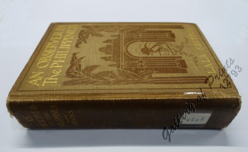
An Observer in the Philippines or Life in Our New Possession...
₱
8,800.00
Add to cart
Details
Ostindische Inseln (Spezialkarten)
₱
8,800.00
Add to cart
Details
Filipinas. 1) Filipinas. – Mujer Indigena. 2) Filipina...
₱
8,800.00
Add to cart
Details
España, sus monumentos y artes, su naturaleza e historia. C...
₱
8,800.00
Add to cart
Details
1. Vue Generale de Manille; 2. Nuestro Senor ……&...
₱
8,800.00
Add to cart
Details
Panorama des Taal-Gebietes. von der Spitze des Maquiling [Pa...
₱
8,800.00
Add to cart
Details
Ein Tagalendorf auf Luzon. (Nach der Natur) [Tagal Village i...
₱
8,800.00
Add to cart
Details
Soirée d’une famille tagale
₱
8,800.00
Add to cart
Details
Interior of the Crater of the Volcano at Taal
₱
8,800.00
Add to cart
Details
Sketches in Manilla. 1. Barber’s shop in Manilla; 2. S...
₱
8,800.00
Add to cart
Details
Mittheilungen aus Justus Perthes’ Geographischer Ansta...
₱
8,600.00
Add to cart
Details
Mittheilungen aus Justus Perthes’ Geographischer Ansta...
₱
8,600.00
Add to cart
Details
Mittheilungen aus Justus Perthes’ Geographischer Ansta...
₱
8,600.00
Add to cart
Details
Mittheilungen aus Justus Perthes’ Geographischer Ansta...
₱
8,000.00
Add to cart
Details
Mittheilungen aus Justus Perthes’ Geographischer Ansta...
₱
8,000.00
Add to cart
Details
Planisphaerium. Coeleste. Verlegt von I.M. Probst 1780
₱
7,850.00
Add to cart
Details
America Septentrionalis Coloniis in Interiorem Virginiam ded...
₱
7,850.00
Add to cart
Details
Palestina in XII. Tribus divisa Iohann Michael Probst excudi...
₱
7,850.00
Add to cart
Details
Magsaysay of the Philippines
₱
7,700.00
Add to cart
Details
Spanish Assault on the Astor Battery at Cavite.
₱
7,700.00
Add to cart
Details
Carte des Costes de Cochinchine Tunquin … [Gulf of Ton...
₱
7,700.00
Add to cart
Details
Map Showing Operations in the Provinces of North and South C...
₱
7,700.00
Add to cart
Details
[Basilan] [untitled] 1st Lt. H. M. Reeve
₱
7,700.00
Add to cart
Details
Sketch of the Engagement of the Prov. Cavalry Brigade. 1st ...
₱
7,700.00
Add to cart
Details
Philippinen – Vulcan von Taal [Taal Volcano]
₱
7,700.00
Add to cart
Details
Vue Generale de Manille.
₱
7,700.00
Add to cart
Details
Treasures of the San Diego
₱
7,700.00
Add to cart
Details
Islas Filipinas inset: Parte Central de la Isla de Luzón
₱
7,700.00
Add to cart
Details
The Philippines- Brigadier-General Loyd Wheaton, U.S.V., Ord...
₱
7,700.00
Add to cart
Details
Previous
1
2
3
…
24
25
26
27
28
29
30
…
61
62
63
Next
Shopping Cart
Ostindische Inseln (Spezialkarten)
1
The Mapping of the Heavens
1
España, sus monumentos y artes, su naturaleza e historia. Cuba, Puerto Rico y Filipinas. [Spain: its monuments and arts, its nature and history. Cuba, Puerto Rico and the Philippines]
1
The German Club Story Centennial Edition 1906 - 2006
1
Le Pic verd de l'Isle de Luçon. [The Green Woodpecker in the Island of Luzon]
1
Islas de Bohol pl. 23
1
Habts. des iles Philippines. [Inhabitants of the Philippine Islands] Habts. de la Nouvelle Hollande. [Inhabitants of New Holland]
1
Advertisements [whole page] [page 1043]
1
Philippine Air Lines Travel Information World Routes
1
Indes Néerlandaises - Iles Philippines - Rapport. Présenté par M. René Brezet, Planteur, Délégué de la Chambre d'Agriculture de la Cochinchine, Chargé de Mission.1922
1
Reduzirte Karte von den Philippinen und den Sulu Inseln [Reduced Map of the Philippines and the Sulu Islands] {insets:}. inset 1: Plan von der Bucht von Manila [Plan of Manila Bay]. inset 2: Islas Batanes. inset 3: Die Nordseite des Mindoro Kan. mit dem Volcan de Taal [Northern Mindoro Channel with Taal Volcano]. inset 4: Sulu-Gebiet an der NW-Küste von Borneo [Sulu-Area near the NW-Coast of Borneo]. inset 5: Südlicher Theil der Sûlûschen Borneo-Küste [Southern Sulu near Borneo Coast]. inset 6: Plan von der Bongobucht [Plan of Bongo Bay].
1
Philippine Islands. Anchorages in Northern Luzon and the Babuyan Islands. Insets: 1) Babuyan Is. - Fuga I. Musa Bay. From the United States Government Chart to 1931. 2) Babuyan Is. - Camiguin I. Port San Pio Quinto. From the United States Government Chart to 1931. 3) Luzon-North-East Coast Port San Vicente. From the United States Government Chart to 1938. 4) Luzon - East Coast Mauban Anchorage. From the Philippine Government Chart of 1957. 5) Luzon - West Coast. Salomague Harbour and Lapog Bay. From the United States Government Chart of 1934. 6) Luzon - West Coast Port Currimao and Gan Bay. From the United States Government Chart of 1934. 7) Luzon - West Coast Solvec Cove. From the United States Government Chart of 1934. 8) Luzon - West Coast Lingayen Gulf. Port Sual with Cabalitian Bay. From the United States Government Chart of 1922. 9) Luzon - West Coast San Fernando Harbour. From the United States Government Chart of 1936.
1
Environs de Sincapour
1
Diccionario Enciclopédico Hispano-Americano de Literatura, Ciencias y Artes. Tomo Octavo. "F-FYT" [Spanish-American Encyclopedic Dictionary of Literature, Sciences and Arts] [volume 8]
1
Atlas Minor ex Tabulis Geographicis…
1
Filipinas, lám.I Filipinas
1
Vue de l'ile de Romero sur le Pasig [View of Romero Island on the Pasig]
1
Chætodon Imperator [Emperor Angelfish] Der Kaiserfisch. L'Empereur du Japon.
1
Pinus Taeda?- Blanco. Pinus Insularis: Endl.- Llanos - DC. [Local Name: Baguio Pine]
1
American President Lines. 1949 Dinner Menu.
1
1) Islas Filipinas: Primera Hoja Central; 2) Islas Filipinas: Segunda Hoja Central; 3) Posesiones de Ultramar (Oceania) - Islas Filipinas
1
Pacifico - Islas Filipinas pl. 1
1
Cart
Checkout
Continue Shopping
22