Tel : +63(2)-7729-8168 | Mobile: +63 917 806 4291
|
Email: gallery@gop.com.ph
My Account
Remember Me
Register
29 Item(s)
-
₱
1,250,670.00
Pêcheurs dans riviere de Passit. [Fishermen on The Pasig River]
1 x
₱
39,600.00
Intérieur d'une case bicole [Interior of a Bicolano House]
1 x
₱
5,500.00
La Favorite au mouillage, durant le Colla de Manille [La Favorite, Moored During a Swell at Manila]
1 x
₱
39,600.00
Citrus Limonia off. Citrus Medica. Bot. Citrone [Mandarin Lime]
1 x
₱
13,200.00
Insulae Marianae Aº 1684...
1 x
₱
39,600.00
Rand McNally Popular Map of Philippine Islands. insets: 1) Philippine Islands and China Sea. 2) Batan and Babuyan Islands.
1 x
₱
4,400.00
The National Geographic Magazine October, 1938, vol. LXXIV, No.4
1 x
₱
3,300.00
[Carte Reduite] Carte Réduite des Isles Philippines Pour Servir Aux Vaisseaux du Roy Dressée au Dépost des Cartes Plans et Journaux de la Marine
1 x
₱
425,000.00
[Carte Reduite] Carte Réduite des Isles Philippines Pour Servir Aux Vaisseaux du Roy Dressée au Dépost des Cartes Plans et Journaux de la Marine
1 x
₱
425,000.00
Dutch Filipiniana. An Annotated Bibliography of Dutch Publications on the Philippines
1 x
₱
3,500.00
Philippine Religious - Carvings in Ivory
1 x
₱
2,500.00
The Escolta, The Principal Thoroughfare of Manila.
1 x
₱
4,400.00
Nuova et Accurata Carta dell 'Isole Filippine... Celebes & c.
1 x
₱
28,600.00
Manille, Pont sur le Passig
1 x
₱
46,200.00
The Murillo Bulletin, Journal of PHIMCOS, Issue No.4
1 x
₱
540.00
Philippine Islands. Luzon Island. North of Latitude 16° 20' North. From the United States Cost Survey Charts to 1925. With additions and correctionsfrom the Philippine Gov't. Charts to 1963. Soundings in hairline enlarged from smaller scale charts.
1 x
₱
11,000.00
[Map Detailing Hong Kong East Canton] insets: 1) [Dongguang] 2) [Hong Kong] 3) [neaby Toushan] [All titles in Japanese]
1 x
₱
11,000.00
India Orientalis
1 x
₱
39,600.00
Anchorages of Luzon, Mindoro and Marinduque. insets: 1) Luzon - West Coast. Bolinao Harbour. From the United States Government Survey of 1904. With additions and corrections from Philippine Gov't. Charts to 1964. 2) Luzon - West Coast. Port Masinloc and Port Matalvi. From the United States Government Surveys of 1937. With additions and corrections from Philippine Gov't. Charts to 1964. 3) Luzon - West Coast. Mariveles Harbour. From the United States Government Chart of 1940. With additions and corrections from Philippine Gov't. Charts to 1964. 4) Luzon - South - West Coast. Batangas. From the Philippine Government Chart of 1956. With additions and corrections to 1964. 5) Luzon - South - West Coast. Nasugbu Bay. From the Philippine Government Chart of 1956. 6) Marinduque. Port Balanacan. From the United States Government Survey of 1908. With additions and corrections from Philippine Gov't. Charts to 1964. 7) Marinduque. Santa Cruz Harbour. From the United States Government Survey of 1908. With additions and corrections from Philippine Gov't. Charts to 1964. 8) Mindoro - North Coast. Port Galera and Varadero Bay. From the United States Government Surveys to 1939. With additions and corrections from Philippine Gov't. Charts to 1964.
1 x
₱
11,000.00
The Murillo Bulletin, Journal of PHIMCOS, Issue No.3
1 x
₱
450.00
A Visit to the Philippine Islands in 1858-59
1 x
₱
45,100.00
Luzon Island. inset : Vicinity of Manila
1 x
₱
5,500.00
Two Ethnographic Collectors in the Late Spanish Philippines: Alexander Schadenberg & P.K.A. Meerkamp van Embden
1 x
₱
3,300.00
Eene audiente bij den Sultan van Soeloe
1 x
₱
11,000.00
1. Embarquement des troupes pour Cuba, a Tampa 2. Depart du "Peking", transportant des troupes a Manille
1 x
₱
5,500.00
The Mapping of the Heavens
1 x
₱
1,980.00
Mapa General Atlas Geografico Descriptivo de la Peninsula Ibérica Yslas Baleares, Canarias y posesiones Españolas de Ultramar por el Comandte Capn de Infa auxiliar que ha sido del Deposito de la Guerra D. Emilio Valverde Y Alvarez. [insets]: 1. Islas Filipinas 2. Posesiones Españolas de golfo del Guinea 3. Antillas Españolas 4. Islas Canarias
1 x
₱
17,700.00
'Malaisie. inset: I. Bassilan
1 x
₱
4,400.00
Das Geheimnis der San Diego Die Entdeckung eines einzigartigen Schatzes im Chinesischen Meer [The Secret of San Diego The Discovery of a Unique Treasure in the China Sea]
1 x
₱
2,200.00
View Cart
Checkout
Home
About Us
Publications
Shop Online
Framing Services
Exhibits
Picture Hanging System
Contact Us
Blogs
View cart
“Das Geheimnis der San Diego Die Entdeckung eines einzigartigen Schatzes im Chinesischen Meer [The Secret of San Diego The Discovery of a Unique Treasure in the China Sea]” has been added to your cart.
Sort by
Default Order
Sort by
Default Order
Sort by
Name
Sort by
Price
Sort by
Date
Sort by
Popularity
Show
30 Products
Show
30 Products
Show
60 Products
Show
90 Products
Class VII Umbrellate, Class VIII Caryophyllous, Class IX Lil...
₱
4,400.00
Add to cart
Details
Orders: 1. Siliculosa; 2. Siliquosa; 3. Polygamia Æqualis; ...
₱
5,500.00
Add to cart
Details
Elaeocarpus Dentatus, Vahl.
₱
5,500.00
Add to cart
Details
The Luneta, Manila
₱
3,300.00
Add to cart
Details
Itinéraire de l’ascension de l’Apó;… {Itiner...
₱
6,600.00
Add to cart
Details
1. Igorot Spinster House in the Mountain Province of Bontoc;...
₱
4,400.00
Add to cart
Details
The Revolt in the Philippine Islands. 1. Philippine Aborigin...
₱
5,500.00
Add to cart
Details
The Spanish – American War. 1. The Governor’s Pa...
₱
3,300.00
Add to cart
Details
The Spanish – American War In the Spanish Trenches at ...
₱
4,400.00
Add to cart
Details
Voyage aux Philippines et en Malaisie
₱
6,600.00
Add to cart
Details
Location of Troops in the Philippine Islands March 31, 1900....
₱
16,500.00
Add to cart
Details
The Philippine Islands (Around the World Program)
₱
4,400.00
Add to cart
Details
Sketch of General Progress – Philippine Islands pl. 2...
₱
5,500.00
Add to cart
Details
Iloílo Straits – From a survey, 1900-1901
₱
7,700.00
Add to cart
Details
The Bontoc Igorot. The Ethnological Survey Publications vol....
₱
14,700.00
Add to cart
Details
East India Archipelago [Eastern Passages to China and Japan]...
₱
36,000.00
Add to cart
Details
East India Archipelago [Eastern Passages to China and Japan]...
₱
39,600.00
Add to cart
Details
Map of the United States showing the Territorial Expansion o...
₱
33,100.00
Add to cart
Details
The Fleet that did not go to the Philippines Admiral Camara&...
₱
11,000.00
Add to cart
Details
El Indicador del Viajero en las Islas Filipinas
₱
77,000.00
Add to cart
Details
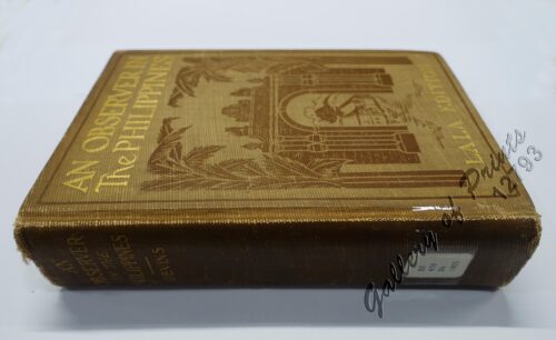
An Observer in the Philippines or Life in Our New Possession...
₱
8,800.00
Add to cart
Details
Die Ostindischen Inseln nach den neuesten Berichtigungen dar...
₱
18,700.00
Add to cart
Details
Isles Philippines a Paris chez le Rouge
₱
22,000.00
Add to cart
Details
A Triumphal Parade of Insurgent Troops in Manila
₱
14,700.00
Add to cart
Details
MADRID. – Exposicion de Filipinas: Exterior de los edi...
₱
8,800.00
Add to cart
Details
Census of the Philippine Islands: 1903. Vol. 1 – Geogr...
₱
50,600.00
Add to cart
Details
Previous
1
2
3
…
13
14
15
16
17
18
19
…
61
62
63
Next
Shopping Cart
Das Geheimnis der San Diego Die Entdeckung eines einzigartigen Schatzes im Chinesischen Meer [The Secret of San Diego The Discovery of a Unique Treasure in the China Sea]
1
'Malaisie. inset: I. Bassilan
1
Mapa General Atlas Geografico Descriptivo de la Peninsula Ibérica Yslas Baleares, Canarias y posesiones Españolas de Ultramar por el Comandte Capn de Infa auxiliar que ha sido del Deposito de la Guerra D. Emilio Valverde Y Alvarez. [insets]: 1. Islas Filipinas 2. Posesiones Españolas de golfo del Guinea 3. Antillas Españolas 4. Islas Canarias
1
The Mapping of the Heavens
1
1. Embarquement des troupes pour Cuba, a Tampa 2. Depart du "Peking", transportant des troupes a Manille
1
Eene audiente bij den Sultan van Soeloe
1
Two Ethnographic Collectors in the Late Spanish Philippines: Alexander Schadenberg & P.K.A. Meerkamp van Embden
1
Luzon Island. inset : Vicinity of Manila
1
A Visit to the Philippine Islands in 1858-59
1
The Murillo Bulletin, Journal of PHIMCOS, Issue No.3
-
Quantity
+
Anchorages of Luzon, Mindoro and Marinduque. insets: 1) Luzon - West Coast. Bolinao Harbour. From the United States Government Survey of 1904. With additions and corrections from Philippine Gov't. Charts to 1964. 2) Luzon - West Coast. Port Masinloc and Port Matalvi. From the United States Government Surveys of 1937. With additions and corrections from Philippine Gov't. Charts to 1964. 3) Luzon - West Coast. Mariveles Harbour. From the United States Government Chart of 1940. With additions and corrections from Philippine Gov't. Charts to 1964. 4) Luzon - South - West Coast. Batangas. From the Philippine Government Chart of 1956. With additions and corrections to 1964. 5) Luzon - South - West Coast. Nasugbu Bay. From the Philippine Government Chart of 1956. 6) Marinduque. Port Balanacan. From the United States Government Survey of 1908. With additions and corrections from Philippine Gov't. Charts to 1964. 7) Marinduque. Santa Cruz Harbour. From the United States Government Survey of 1908. With additions and corrections from Philippine Gov't. Charts to 1964. 8) Mindoro - North Coast. Port Galera and Varadero Bay. From the United States Government Surveys to 1939. With additions and corrections from Philippine Gov't. Charts to 1964.
1
India Orientalis
1
[Map Detailing Hong Kong East Canton] insets: 1) [Dongguang] 2) [Hong Kong] 3) [neaby Toushan] [All titles in Japanese]
1
Philippine Islands. Luzon Island. North of Latitude 16° 20' North. From the United States Cost Survey Charts to 1925. With additions and correctionsfrom the Philippine Gov't. Charts to 1963. Soundings in hairline enlarged from smaller scale charts.
1
The Murillo Bulletin, Journal of PHIMCOS, Issue No.4
-
Quantity
+
Manille, Pont sur le Passig
1
Nuova et Accurata Carta dell 'Isole Filippine... Celebes & c.
1
The Escolta, The Principal Thoroughfare of Manila.
1
Philippine Religious - Carvings in Ivory
1
Dutch Filipiniana. An Annotated Bibliography of Dutch Publications on the Philippines
1
[Carte Reduite] Carte Réduite des Isles Philippines Pour Servir Aux Vaisseaux du Roy Dressée au Dépost des Cartes Plans et Journaux de la Marine
1
[Carte Reduite] Carte Réduite des Isles Philippines Pour Servir Aux Vaisseaux du Roy Dressée au Dépost des Cartes Plans et Journaux de la Marine
1
The National Geographic Magazine October, 1938, vol. LXXIV, No.4
1
Rand McNally Popular Map of Philippine Islands. insets: 1) Philippine Islands and China Sea. 2) Batan and Babuyan Islands.
1
Insulae Marianae Aº 1684...
1
Citrus Limonia off. Citrus Medica. Bot. Citrone [Mandarin Lime]
1
La Favorite au mouillage, durant le Colla de Manille [La Favorite, Moored During a Swell at Manila]
1
Intérieur d'une case bicole [Interior of a Bicolano House]
1
Pêcheurs dans riviere de Passit. [Fishermen on The Pasig River]
1
Cart
Checkout
Continue Shopping
29