Tel : +63(2)-7729-8168 | Mobile: +63 917 806 4291|Email: gallery@gop.com.ph
  • My Account

    Register
  • 24 Item(s) - ₱541,300.00
    Sheet No. 2. Road Map from Cabanatuan to Lupao plotted during Advance of Gen. Young's Brigade of 1st Div. 8th A. C. Maj. Gen. H. W. Lawton U. S. V. Commanding. Prepared under direction of John C. Oakes. 1st Lieut Corps of Engineers Division Engineer.1 x ₱13,200.00
    Pisonia Sylvestris. T. et B. Pisonia Alba. Spink [English: Lettuce Tree. Tagalog: Maluko] [Named after the Dutch Botanist - Willem Pison]1 x ₱26,400.00
    Philippine Islands1 x ₱6,600.00
    Anchorages of Luzon, Mindoro and Marinduque. insets: 1) Luzon - West Coast. Bolinao Harbour. From the United States Government Survey of 1904. With additions and corrections from Philippine Gov't. Charts to 1964. 2) Luzon - West Coast. Port Masinloc and Port Matalvi. From the United States Government Surveys of 1937. With additions and corrections from Philippine Gov't. Charts to 1964. 3) Luzon - West Coast. Mariveles Harbour. From the United States Government Chart of 1940. With additions and corrections from Philippine Gov't. Charts to 1964. 4) Luzon - South - West Coast. Batangas. From the Philippine Government Chart of 1956. With additions and corrections to 1964. 5) Luzon - South - West Coast. Nasugbu Bay. From the Philippine Government Chart of 1956. 6) Marinduque. Port Balanacan. From the United States Government Survey of 1908. With additions and corrections from Philippine Gov't. Charts to 1964. 7) Marinduque. Santa Cruz Harbour. From the United States Government Survey of 1908. With additions and corrections from Philippine Gov't. Charts to 1964. 8) Mindoro - North Coast. Port Galera and Varadero Bay. From the United States Government Surveys to 1939. With additions and corrections from Philippine Gov't. Charts to 1964.1 x ₱11,000.00
    Bahia de Bacoor1 x ₱9,900.00
    Philippine Islands. insets: 1) Manila to Dagupan; 2) Manila; 3) Philippine Islands and the China Sea; 4) Batanes (Bashee) and Babuyanes Is.; 5) Sulu Archipelago1 x ₱13,200.00
    Album: Islas Filipinas 1663-18881 x ₱32,000.00
    The Life of Ferdinand Magellan and the First Circumnavigation of the Globe. 1480-1521.1 x ₱11,000.00
    Sketch of Navitac and Vicinity1 x ₱4,400.00
    Dillenia Reifferscheidia: - [Local Name: Katmon]1 x ₱39,600.00
    Fève De St. Ignace. [Jesuit Bean / Aguwason] [Strychnos ignati]1 x ₱6,600.00
    India Orientalis1 x ₱77,000.00
    Quezon, Paladin of Philippine Freedom1 x ₱4,400.00
    The Harbour, Manila.1 x ₱6,600.00
    1) Carte des Isles Philippines (1e feuille) Kaart der Philippines Eilanden, Geschikt op de Spaansche Kaart van Pater Murillo de Velarde 1.ste Blad. Door den Hr. Bellin Ingr. des Fransen Zeevaards. 2) Carte des Isles Philippines (2e feuille) Kaart der Philippines Eilanden, Geschikt op de Spaansche Kaart van Pater Murillo de Velarde 2.de Blad. Door den Hr. Bellin Ingr. des Fransen Zeevaards.1 x ₱46,200.00
    Canal a Benondo.1 x ₱4,400.00
    Japan A Cartographic Vision1 x ₱4,400.00
    Une Rue de Manille [Manila Street]1 x ₱49,500.00
    Manille (Oceanie)1 x ₱13,200.00
    Chart of the China Sea / inscribed to Mons. d'Après de Mannevillette, the ingenious author of the Neptune Oriental as a tribute due to his labours for the benefit of navigation and in acknowledgement of his many signal favours to A. Dalrymple1 x ₱99,000.00
    The Illustrated London News Vol. 32 - No. 8971 x ₱6,600.00
    San Antonio. Luzon 1:50,0001 x ₱9,900.00
    Calao à bec rouge, du Sénégal [Red-billed Hornbill from Senegal]1 x ₱6,600.00
    La Corvette La Favorite au mouillage de Manille (La Favorite Anchored in Manila)1 x ₱39,600.00
    View Cart
    Checkout
Gallery of Prints Logo Gallery of Prints Logo
  • Home
  • About Us
  • Publications
  • Shop Online
  • Framing Services
  • Exhibits
  • Picture Hanging System
  • Contact Us
  • Blogs
  • Sort by Default Order
    • Sort by Default Order
    • Sort by Name
    • Sort by Price
    • Sort by Date
    • Sort by Popularity
  • Show 30 Products
    • Show 30 Products
    • Show 60 Products
    • Show 90 Products
  • Mapa de las Islas Filipinas (inset: Islas Marianas)

    ₱30,000.00
    Add to cart Details
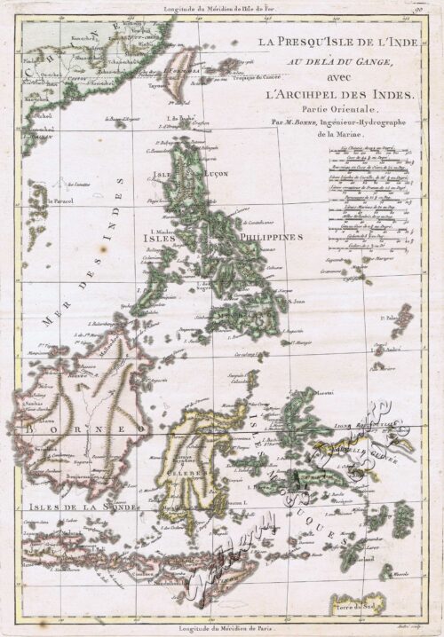
  • La Presqu’Isle de L’Inde Au Dela du Gange, avec ...

    ₱18,700.00
    Add to cart Details
  • Philippine Islands insets: 1) Manila to Dagupan 2) Manila 3)...

    ₱17,200.00
    Add to cart Details

Search Shop:

Product Categories

  • Modern Books [Other Countries] (20)
  • Antique Prints of the Philippines (1403)
    • Botany/Flora [Flowers/Fruits] (129)
    • Cartography [Maps] (626)
    • Costumes & People (213)
    • Ichthyology [Fishes] (13)
    • Ornithology [Birds] (64)
    • Scripophily [Stock Certificates] (14)
    • Views & Various [Other Countries] (20)
    • Views & Various [Philippines] (302)
    • Zoology/Fauna [Animals] (22)
  • Vintage Prints/Maps/Views[1926-1999] (40)
  • The Murillo 1734 Map of the Philippines – Reproduction (1)
  • Antique Books about the Philippines (150)
  • Vintage Books about the Philippines [1926-1999] (123)
  • Modern Books about the Philippines [after 1999] (129)
  • Uncategorized Items (16)
For our clients located in the Philippines:

Valuable Prints in Acid-free Matting

All original antique prints are mounted acid free with an acid-free passepartout (museum-style matting) and shipped with an acid-free transparent Polyethylene wrap

Your Cart

CONTACT US

Phone: +63(2)-7729-8168
Fax: +63(2)-7729-8168
Mobile: +63 917 806 4291
Email: gallery@gop.com.ph

SHOWROOM

Lietz Industrial Complex,
Edison Avenue (P. Leviste),
Km 14 SLEX
1700 Parañaque City

MAILING ADDRESS

RLI Gallery Systems, Inc.
POB 2348 MCPO,
1263 Makati City, Metro Manila
Philippines

Co-founder:
Philippine Map Collectors Society (PHIMCOS)
International Representative,
Philippines
© 1995 - 2025 by Rudolf Lietz, Inc. All rights reserved.
Disclaimer • Liability | Warranty • Return Policy
Shopping Cart
La Corvette La Favorite au mouillage de Manille (La Favorite Anchored in Manila)
1
Calao à bec rouge, du Sénégal [Red-billed Hornbill from Senegal]
1
San Antonio. Luzon 1:50,000
1
The Illustrated London News Vol. 32 - No. 897
1
Chart of the China Sea / inscribed to Mons. d'Après de Mannevillette, the ingenious author of the Neptune Oriental as a tribute due to his labours for the benefit of navigation and in acknowledgement of his many signal favours to A. Dalrymple
1
Manille (Oceanie)
1
Une Rue de Manille [Manila Street]
1
Japan A Cartographic Vision
1
Canal a Benondo.
1
1) Carte des Isles Philippines (1e feuille) Kaart der Philippines Eilanden, Geschikt op de Spaansche Kaart van Pater Murillo de Velarde 1.ste Blad. Door den Hr. Bellin Ingr. des Fransen Zeevaards. 2) Carte des Isles Philippines (2e feuille) Kaart der Philippines Eilanden, Geschikt op de Spaansche Kaart van Pater Murillo de Velarde 2.de Blad. Door den Hr. Bellin Ingr. des Fransen Zeevaards.
1
The Harbour, Manila.
1
Quezon, Paladin of Philippine Freedom
1
India Orientalis
1
Fève De St. Ignace. [Jesuit Bean / Aguwason] [Strychnos ignati]
1
Dillenia Reifferscheidia: - [Local Name: Katmon]
1
Sketch of Navitac and Vicinity
1
The Life of Ferdinand Magellan and the First Circumnavigation of the Globe. 1480-1521.
1
Album: Islas Filipinas 1663-1888
1
Philippine Islands. insets: 1) Manila to Dagupan; 2) Manila; 3) Philippine Islands and the China Sea; 4) Batanes (Bashee) and Babuyanes Is.; 5) Sulu Archipelago
1
Bahia de Bacoor
1
Anchorages of Luzon, Mindoro and Marinduque. insets: 1) Luzon - West Coast. Bolinao Harbour. From the United States Government Survey of 1904. With additions and corrections from Philippine Gov't. Charts to 1964. 2) Luzon - West Coast. Port Masinloc and Port Matalvi. From the United States Government Surveys of 1937. With additions and corrections from Philippine Gov't. Charts to 1964. 3) Luzon - West Coast. Mariveles Harbour. From the United States Government Chart of 1940. With additions and corrections from Philippine Gov't. Charts to 1964. 4) Luzon - South - West Coast. Batangas. From the Philippine Government Chart of 1956. With additions and corrections to 1964. 5) Luzon - South - West Coast. Nasugbu Bay. From the Philippine Government Chart of 1956. 6) Marinduque. Port Balanacan. From the United States Government Survey of 1908. With additions and corrections from Philippine Gov't. Charts to 1964. 7) Marinduque. Santa Cruz Harbour. From the United States Government Survey of 1908. With additions and corrections from Philippine Gov't. Charts to 1964. 8) Mindoro - North Coast. Port Galera and Varadero Bay. From the United States Government Surveys to 1939. With additions and corrections from Philippine Gov't. Charts to 1964.
1
Philippine Islands
1
Pisonia Sylvestris. T. et B. Pisonia Alba. Spink [English: Lettuce Tree. Tagalog: Maluko] [Named after the Dutch Botanist - Willem Pison]
1
Sheet No. 2. Road Map from Cabanatuan to Lupao plotted during Advance of Gen. Young's Brigade of 1st Div. 8th A. C. Maj. Gen. H. W. Lawton U. S. V. Commanding. Prepared under direction of John C. Oakes. 1st Lieut Corps of Engineers Division Engineer.
1
Cart
Checkout
Continue Shopping
24