Tel : +63(2)-7729-8168 | Mobile: +63 917 806 4291
|
Email: gallery@gop.com.ph
My Account
Remember Me
Register
12 Item(s)
-
₱
403,800.00
Nova et vera exhibitio..Insularum Marianarum… inset: [Guam]
1 x
₱
50,600.00
Map of the World on Mercators Projection
1 x
₱
6,600.00
Progress Map of Signal Corps Telegraph Lines & Cables in the Military Division of the Philippines… corrected to July 1st, 1900.
1 x
₱
26,400.00
Road Sketch of Operations of Col. Hood's Command, 16th Infty. Drawn By Guy G. Palmer 1st Lieut 16th U.S. Infty.
1 x
₱
6,600.00
Chief and Escort of Aetas, or Negritos, The Original Natives of the Philippines, Living in Mountains.
1 x
₱
3,300.00
Cynometra Cauliflora. L. [Indonesia: Nam-nam; English translation"flowers on the stem"]
1 x
₱
26,400.00
Chart of the Coast of China and of the Japan Islands including the Marianes and a part of the Philippines. Compiled by order of Commodore M. C. Perry. U.S.N. from the latest authorities with additions and corrections by the U.S. Japan Expedition by Lieuts. W. L. Maury and S. Bent. U.S.N.
1 x
₱
39,600.00
Ports in the Philippine Islands. insets: 1) Luzon I. - West Coast. Manila and Cavite Anchorages. From the United States Government Charts to 1950. With additions and corrections to 1959. 2) Luzon I. - West Coast. Manila Harbour. From the United States Government Charts to 1950. With additions and corrections to 1959.
1 x
₱
13,200.00
Plan of the Bay of Manilla in the Isle of Luconia, the Principal of the Philippine Islands, Surveyed by Señor Alexandro Malaspina and Communicated By Captn. G.G. Richardson.
1 x
₱
120,000.00
Cascos de la Laguna, a la voile. ["Cascos" from La Laguna, under Sail]
1 x
₱
99,000.00
Carte de L'Ocean Meridional (Atlantic Ocean)
1 x
₱
5,500.00
Voyage aux Philippines et en Malaisie
1 x
₱
6,600.00
View Cart
Checkout
Home
About Us
Publications
Shop Online
Framing Services
Exhibits
Picture Hanging System
Contact Us
Blogs
View cart
“Voyage aux Philippines et en Malaisie” has been added to your cart.
Sort by
Default Order
Sort by
Default Order
Sort by
Name
Sort by
Price
Sort by
Date
Sort by
Popularity
Show
30 Products
Show
30 Products
Show
60 Products
Show
90 Products
Filipinas. 1) Filipinas. – Mujer Indigena. 2) Filipina...
₱
8,800.00
Add to cart
Details
Cróquis de Silang y sus Alrededores. Conocimo por plano Chi...
₱
7,700.00
Add to cart
Details
Cróquis de la acción de Silang. (19 de Febrero de 1897.)
₱
7,700.00
Add to cart
Details
Acciones y operaciones sobre Silang. (Desde el 15 al 18 Febr...
₱
7,700.00
Add to cart
Details
The Philippine Islands showing location of Resources and Ind...
₱
46,200.00
Add to cart
Details
Carte des Îles Philippines, Célebès et Moluques….Duperr...
₱
140,000.00
Add to cart
Details
Le Isole della Sonda, Molucche, e Filippine
₱
121,000.00
Add to cart
Details
Charte von China nach Murdochischer Projection entworfen… ...
₱
39,600.00
Add to cart
Details
De Sinu Baye La Baye [Gulf of Albay]
₱
49,600.00
Add to cart
Details
1) A Dangerous Shoal… 2) Joseph Freewills Island. 3) The S...
₱
13,500.00
Add to cart
Details
A Chart of the Channel in the Phillippine [sic] Islands thro...
₱
39,600.00
Add to cart
Details
1. Borneo. 2. The Philippine Islands.
₱
15,400.00
Add to cart
Details
Isole Filippine
₱
155,000.00
Add to cart
Details
Islas Filipinas – Expedicion militar a Mindanao. 1. Ba...
₱
9,900.00
Add to cart
Details
Exposicion de Filipinas en el Parque de Madrid. 1. Pabellon ...
₱
9,900.00
Add to cart
Details
Exposicion de Filipinas en el Parque de Madrid. Interior del...
₱
9,900.00
Add to cart
Details
Archipel Asiatique. inset maps: 1. Manille et Environs. 2. L...
₱
15,700.00
Add to cart
Details
Map Showing Road Surveys and Construction Bureau of Engineer...
₱
13,200.00
Add to cart
Details
Map of the Island of Luzon
₱
7,700.00
Add to cart
Details
Aux Philippines L’amiral Dewey et le Général Otis da...
₱
7,700.00
Add to cart
Details
Manila Bay The Crossroads of Asia
₱
11,000.00
Add to cart
Details
National Geographic September, 1990, Vol. 178, No. 3. Track ...
₱
4,400.00
Add to cart
Details
Class VII Umbrellate, Class VIII Caryophyllous, Class IX Lil...
₱
4,400.00
Add to cart
Details
Orders: 1. Siliculosa; 2. Siliquosa; 3. Polygamia Æqualis; ...
₱
5,500.00
Add to cart
Details
Elaeocarpus Dentatus, Vahl.
₱
5,500.00
Add to cart
Details
The Luneta, Manila
₱
3,300.00
Add to cart
Details
Itinéraire de l’ascension de l’Apó;… {Itiner...
₱
6,600.00
Add to cart
Details
1. Igorot Spinster House in the Mountain Province of Bontoc;...
₱
4,400.00
Add to cart
Details
The Revolt in the Philippine Islands. 1. Philippine Aborigin...
₱
5,500.00
Add to cart
Details
The Spanish – American War. 1. The Governor’s Pa...
₱
3,300.00
Add to cart
Details
The Spanish – American War In the Spanish Trenches at ...
₱
4,400.00
Add to cart
Details
Voyage aux Philippines et en Malaisie
₱
6,600.00
Add to cart
Details
Location of Troops in the Philippine Islands March 31, 1900....
₱
16,500.00
Add to cart
Details
The Philippine Islands (Around the World Program)
₱
4,400.00
Add to cart
Details
Sketch of General Progress – Philippine Islands pl. 2...
₱
5,500.00
Add to cart
Details
Iloílo Straits – From a survey, 1900-1901
₱
7,700.00
Add to cart
Details
The Bontoc Igorot. The Ethnological Survey Publications vol....
₱
14,700.00
Add to cart
Details
East India Archipelago [Eastern Passages to China and Japan]...
₱
36,000.00
Add to cart
Details
East India Archipelago [Eastern Passages to China and Japan]...
₱
39,600.00
Add to cart
Details
Map of the United States showing the Territorial Expansion o...
₱
33,100.00
Add to cart
Details
The Fleet that did not go to the Philippines Admiral Camara&...
₱
11,000.00
Add to cart
Details
El Indicador del Viajero en las Islas Filipinas
₱
77,000.00
Add to cart
Details
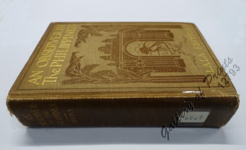
An Observer in the Philippines or Life in Our New Possession...
₱
8,800.00
Add to cart
Details
Die Ostindischen Inseln nach den neuesten Berichtigungen dar...
₱
18,700.00
Add to cart
Details
Isles Philippines a Paris chez le Rouge
₱
22,000.00
Add to cart
Details
A Triumphal Parade of Insurgent Troops in Manila
₱
14,700.00
Add to cart
Details
MADRID. – Exposicion de Filipinas: Exterior de los edi...
₱
8,800.00
Add to cart
Details
Census of the Philippine Islands: 1903. Vol. 1 – Geogr...
₱
50,600.00
Add to cart
Details
Previous
1
2
3
…
5
6
7
8
9
10
11
…
30
31
32
Next
Shopping Cart
Voyage aux Philippines et en Malaisie
1
Carte de L'Ocean Meridional (Atlantic Ocean)
1
Cascos de la Laguna, a la voile. ["Cascos" from La Laguna, under Sail]
1
Plan of the Bay of Manilla in the Isle of Luconia, the Principal of the Philippine Islands, Surveyed by Señor Alexandro Malaspina and Communicated By Captn. G.G. Richardson.
1
Ports in the Philippine Islands. insets: 1) Luzon I. - West Coast. Manila and Cavite Anchorages. From the United States Government Charts to 1950. With additions and corrections to 1959. 2) Luzon I. - West Coast. Manila Harbour. From the United States Government Charts to 1950. With additions and corrections to 1959.
1
Chart of the Coast of China and of the Japan Islands including the Marianes and a part of the Philippines. Compiled by order of Commodore M. C. Perry. U.S.N. from the latest authorities with additions and corrections by the U.S. Japan Expedition by Lieuts. W. L. Maury and S. Bent. U.S.N.
1
Cynometra Cauliflora. L. [Indonesia: Nam-nam; English translation"flowers on the stem"]
1
Chief and Escort of Aetas, or Negritos, The Original Natives of the Philippines, Living in Mountains.
1
Road Sketch of Operations of Col. Hood's Command, 16th Infty. Drawn By Guy G. Palmer 1st Lieut 16th U.S. Infty.
1
Progress Map of Signal Corps Telegraph Lines & Cables in the Military Division of the Philippines… corrected to July 1st, 1900.
1
Map of the World on Mercators Projection
1
Nova et vera exhibitio..Insularum Marianarum… inset: [Guam]
1
Cart
Checkout
Continue Shopping
12