Tel : +63(2)-7729-8168 | Mobile: +63 917 806 4291
|
Email: gallery@gop.com.ph
My Account
Remember Me
Register
13 Item(s)
-
₱
134,600.00
[ Mayon Volcano]
1 x
₱
4,400.00
Twenty Years in the Philippine Islands: [A critical review with excerpts from the work of P. de la Gironiere. A rare original article from the Blackwood's Edinburgh Magazine.]
1 x
₱
6,600.00
Map of Pacific Ocean by Robinson H. E. C. Pty. Ltd. Mercators Projection insets: 1) Kiska. 2) Attu. 3) Sonsorol Is. 4) Palau Is. 5) Ngulu Is. 6) Yap Is. 7) Ulithi Is. 8) Sorol Is. 9) Eauripik Is. 10) Woleai Is. 11) Ifalik Is. 12) Faraulep Is. 13) Elato & Lamotrek Is. 14) Namonuito Is. 15) Pulap Is. 16) Puluwat Is. 17) Truk Is. 18) Ujelang Atoll. 19) Eniwetok Atoll. 20) Bikini Atoll. 21) Rongelap Atoll. 22) Kwajalein Atoll. 23) Jaluit Atoll. 24) Makin. 25) Paramushiro. 26) Chichi Is. 27) Marcus. 28) Hall Is. 29) Losap Is. 30) Namoluk Is. 31) Nomoi Is. 32) Oroluk Lagoon. 33) Ngatik Is. 34) Pakin Is. 35) Ant Is. 36) Senyavin Is. 37) Mokil Is. 38) Pingelap Is. 39) Kusaie Id. 40) Wotje Atoll. 41) Maloelap Atoll. 42) Arno Atoll. 43) Mili Atoll. 44) Ebon Atoll. 45) Tarawa. 46) Japan. 47) Saipan. 48) Hawaiian Islands. 49) Midway Id. 50) [Bataan / Manila Bay]. 51) Philippine Islands. 52) Wake. 53) Guam. 54) Canton Id. 55) Fiji.
1 x
₱
14,700.00
Philippine Islands. Samar and Leyte. San Juanico Strait and Approaches. From the United States Government Surveys to 1935. With Additions and Corrections from the Philippine Gov't. Charts to 1957. inset: 1) Northern Entrance to San Juanico Strait. From the United States Government Surveys of 1925. With Additions and Corrections from the Philippine Gov't. Charts to 1957.
1 x
₱
11,000.00
1. Riviere de Passit a Manille [Pasig River in Manila]. 2. Casa Matta de Pandacon [Nipa House at Pandacan].
1 x
₱
4,400.00
Bohol
1 x
₱
17,600.00
The Ransom of Manilla; or, England's Ally. An Historical Play in Five Acts.
1 x
₱
9,900.00
1. Fischerflösse in Manilla [Fishing Raft]; 3. Banka, Boot zur Ueberfahrt [Outrigger Boat Ferry]; 2. Eingang von Macao; 4. Theil von Macao.
1 x
₱
4,400.00
Isles Philippines et Moluques
1 x
₱
18,700.00
Tabula Geographica oder Stätt-Zeiger darin[n]en zusehen die Distantien Zwischen den Vornehmsten Stätten in Europa. [Distance Table in French Miles Between European Cities]
1 x
₱
3,300.00
Europe
1 x
₱
3,300.00
Zalacca Edulis. Reinw. [English: Snake Fruit Tree; Indonesia: Salak Tree]
1 x
₱
34,100.00
[Sketch of the Area Between San Nicolas to Bambang]
1 x
₱
2,200.00
View Cart
Checkout
Home
About Us
Publications
Shop Online
Framing Services
Exhibits
Picture Hanging System
Contact Us
Blogs
View cart
“[Sketch of the Area Between San Nicolas to Bambang]” has been added to your cart.
Sort by
Default Order
Sort by
Default Order
Sort by
Name
Sort by
Price
Sort by
Date
Sort by
Popularity
Show
30 Products
Show
30 Products
Show
60 Products
Show
90 Products
Philippine Religious – Carvings in Ivory
₱
2,500.00
Add to cart
Details
The Far East Compiled and Drawn in the Cartographic Section ...
₱
6,600.00
Add to cart
Details
Sale!
Karte der St. Gotthard-Bahn, Taf.2 [Map of The Gotthard-Rail...
₱
6,600.00
₱
5,280.00
Add to cart
Details
The National Geographic Magazine September, 1952, vol. CII, ...
₱
1,100.00
Add to cart
Details
The Manila-Acapulco Galleons: The Treasure Ships of the Paci...
₱
4,400.00
Add to cart
Details
Spanish Galleon 1530 – 1690 New Vanguard # 96
₱
2,200.00
Add to cart
Details
When Britain Ruled the Philippines 1762-1764
₱
2,200.00
Add to cart
Details
Iloilo A Rich and Noble Land
₱
7,500.00
Add to cart
Details
The Mysteries of Taal: A Philippine Volcano and Lake, Her S...
₱
900.00
Add to cart
Details
Northern Island New Zealand
₱
4,400.00
Add to cart
Details
South Island New Zealand
₱
4,400.00
Add to cart
Details
Map of Pacific Ocean by Robinson H. E. C. Pty. Ltd. Mercat...
₱
14,700.00
Add to cart
Details
Zambales
₱
17,600.00
Add to cart
Details
Leyte
₱
17,600.00
Add to cart
Details
Bohol
₱
17,600.00
Add to cart
Details
Rizal
₱
17,600.00
Add to cart
Details
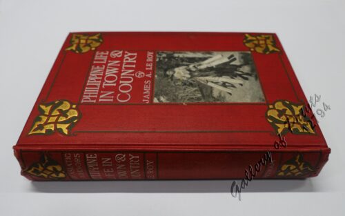
Philippine Life in Town & Country.
₱
8,800.00
Add to cart
Details
Philippines
₱
8,800.00
Add to cart
Details
The Mapping of the Heavens
₱
1,980.00
Add to cart
Details
Manila Harbor Complimentary Map of the City of Manila
₱
22,000.00
Add to cart
Details
Previous
1
2
3
…
60
61
62
63
Shopping Cart
[Sketch of the Area Between San Nicolas to Bambang]
1
Zalacca Edulis. Reinw. [English: Snake Fruit Tree; Indonesia: Salak Tree]
1
Europe
1
Tabula Geographica oder Stätt-Zeiger darin[n]en zusehen die Distantien Zwischen den Vornehmsten Stätten in Europa. [Distance Table in French Miles Between European Cities]
1
Isles Philippines et Moluques
1
1. Fischerflösse in Manilla [Fishing Raft]; 3. Banka, Boot zur Ueberfahrt [Outrigger Boat Ferry]; 2. Eingang von Macao; 4. Theil von Macao.
1
The Ransom of Manilla; or, England's Ally. An Historical Play in Five Acts.
1
Bohol
1
1. Riviere de Passit a Manille [Pasig River in Manila]. 2. Casa Matta de Pandacon [Nipa House at Pandacan].
1
Philippine Islands. Samar and Leyte. San Juanico Strait and Approaches. From the United States Government Surveys to 1935. With Additions and Corrections from the Philippine Gov't. Charts to 1957. inset: 1) Northern Entrance to San Juanico Strait. From the United States Government Surveys of 1925. With Additions and Corrections from the Philippine Gov't. Charts to 1957.
1
Map of Pacific Ocean by Robinson H. E. C. Pty. Ltd. Mercators Projection insets: 1) Kiska. 2) Attu. 3) Sonsorol Is. 4) Palau Is. 5) Ngulu Is. 6) Yap Is. 7) Ulithi Is. 8) Sorol Is. 9) Eauripik Is. 10) Woleai Is. 11) Ifalik Is. 12) Faraulep Is. 13) Elato & Lamotrek Is. 14) Namonuito Is. 15) Pulap Is. 16) Puluwat Is. 17) Truk Is. 18) Ujelang Atoll. 19) Eniwetok Atoll. 20) Bikini Atoll. 21) Rongelap Atoll. 22) Kwajalein Atoll. 23) Jaluit Atoll. 24) Makin. 25) Paramushiro. 26) Chichi Is. 27) Marcus. 28) Hall Is. 29) Losap Is. 30) Namoluk Is. 31) Nomoi Is. 32) Oroluk Lagoon. 33) Ngatik Is. 34) Pakin Is. 35) Ant Is. 36) Senyavin Is. 37) Mokil Is. 38) Pingelap Is. 39) Kusaie Id. 40) Wotje Atoll. 41) Maloelap Atoll. 42) Arno Atoll. 43) Mili Atoll. 44) Ebon Atoll. 45) Tarawa. 46) Japan. 47) Saipan. 48) Hawaiian Islands. 49) Midway Id. 50) [Bataan / Manila Bay]. 51) Philippine Islands. 52) Wake. 53) Guam. 54) Canton Id. 55) Fiji.
1
Twenty Years in the Philippine Islands: [A critical review with excerpts from the work of P. de la Gironiere. A rare original article from the Blackwood's Edinburgh Magazine.]
1
[ Mayon Volcano]
1
Cart
Checkout
Continue Shopping
13