Tel : +63(2)-7729-8168 | Mobile: +63 917 806 4291
|
Email: gallery@gop.com.ph
My Account
Remember Me
Register
13 Item(s)
-
₱
898,800.00
Philippine Islands. Sibuyan Sea to San Bernardino Strait. From the United States Government Charts to 1934.
1 x
₱
11,000.00
Map Showing Operations Provisional Brigade - 1st Division from October 7th to 15th 1899. Brig. General Theodore Schwan commanding. Prepared under direction of General Schwan by Wm L. Sibert, Captain of Engineers, Chief Engineer.
1 x
₱
9,900.00
1) Carte des Isles Philippines (1e feuille); 2) Carte des Isles Philippines (2e feuille)
1 x
₱
44,100.00
Map of Insurgent Entrenchments in Vicinity of Puente Julian. 1.2 miles south of Imus. Luzon, P.I. Scene of Engagement of Company C and Scouts, 4th U.S. Inf. commanded, respectively by 1st Lieut. Ward Cheney, 4th U.S. Inf. and 2nd Lieut. Henry Way, 4th U.S. Inf. Jan. 7, 1900
1 x
₱
9,900.00
Philippine Archipelago Mindanao Island Sarangani Islands and Adjacent Coast From a Spanish survey in 1874.
1 x
₱
5,500.00
Filipinas. - India Elegante.
1 x
₱
5,500.00
Port of Manila, Trade Center of the Pacific Year Book 1929
1 x
₱
8,800.00
Italien in seine unterschiedene Laender eingetheilet
1 x
₱
3,300.00
Les Isles Philippines 1682
1 x
₱
22,000.00
Chætodon Imperator [Emperor Angelfish] Der Kaiserfisch. L'Empereur du Japon.
1 x
₱
4,400.00
Aussicht aus einem Fenster von San Miguel. [View from a Window of San Miguel]
1 x
₱
4,400.00
Indios de las Cercanias de Manila. [Natives from the Vicinity of Manila.]
1 x
₱
220,000.00
Historia de la Provincia de Philipinas de la Compañia de Jesus. Segunda Parte, que comprehende los progresos de esta Provincia desde el Año de 1616, hasta el de 1716.
1 x
₱
550,000.00
View Cart
Checkout
Home
About Us
Publications
Shop Online
Framing Services
Exhibits
Picture Hanging System
Contact Us
Blogs
View cart
“Historia de la Provincia de Philipinas de la Compañia de Jesus. Segunda Parte, que comprehende los progresos de esta Provincia desde el Año de 1616, hasta el de 1716.” has been added to your cart.
Sort by
Date
Sort by
Default Order
Sort by
Name
Sort by
Price
Sort by
Date
Sort by
Popularity
Show
30 Products
Show
30 Products
Show
60 Products
Show
90 Products
Philippine Religious – Carvings in Ivory
₱
2,500.00
Add to cart
Details
The Far East Compiled and Drawn in the Cartographic Section ...
₱
6,600.00
Add to cart
Details
Sale!
Karte der St. Gotthard-Bahn, Taf.2 [Map of The Gotthard-Rail...
₱
6,600.00
₱
5,280.00
Add to cart
Details
The National Geographic Magazine September, 1952, vol. CII, ...
₱
1,100.00
Add to cart
Details
The Manila-Acapulco Galleons: The Treasure Ships of the Paci...
₱
4,400.00
Add to cart
Details
Spanish Galleon 1530 – 1690 New Vanguard # 96
₱
2,200.00
Add to cart
Details
When Britain Ruled the Philippines 1762-1764
₱
2,200.00
Add to cart
Details
Iloilo A Rich and Noble Land
₱
7,500.00
Add to cart
Details
The Mysteries of Taal: A Philippine Volcano and Lake, Her S...
₱
900.00
Add to cart
Details
Northern Island New Zealand
₱
4,400.00
Add to cart
Details
South Island New Zealand
₱
4,400.00
Add to cart
Details
Map of Pacific Ocean by Robinson H. E. C. Pty. Ltd. Mercat...
₱
14,700.00
Add to cart
Details
Zambales
₱
17,600.00
Add to cart
Details
Leyte
₱
17,600.00
Add to cart
Details
Bohol
₱
17,600.00
Add to cart
Details
Rizal
₱
17,600.00
Add to cart
Details
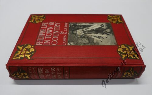
Philippine Life in Town & Country.
₱
8,800.00
Add to cart
Details
Philippines
₱
8,800.00
Add to cart
Details
The Mapping of the Heavens
₱
1,980.00
Add to cart
Details
Manila Harbor Complimentary Map of the City of Manila
₱
22,000.00
Add to cart
Details
Previous
1
2
3
…
60
61
62
63
Shopping Cart
Historia de la Provincia de Philipinas de la Compañia de Jesus. Segunda Parte, que comprehende los progresos de esta Provincia desde el Año de 1616, hasta el de 1716.
1
Indios de las Cercanias de Manila. [Natives from the Vicinity of Manila.]
1
Aussicht aus einem Fenster von San Miguel. [View from a Window of San Miguel]
1
Chætodon Imperator [Emperor Angelfish] Der Kaiserfisch. L'Empereur du Japon.
1
Les Isles Philippines 1682
1
Italien in seine unterschiedene Laender eingetheilet
1
Port of Manila, Trade Center of the Pacific Year Book 1929
1
Filipinas. - India Elegante.
1
Philippine Archipelago Mindanao Island Sarangani Islands and Adjacent Coast From a Spanish survey in 1874.
1
Map of Insurgent Entrenchments in Vicinity of Puente Julian. 1.2 miles south of Imus. Luzon, P.I. Scene of Engagement of Company C and Scouts, 4th U.S. Inf. commanded, respectively by 1st Lieut. Ward Cheney, 4th U.S. Inf. and 2nd Lieut. Henry Way, 4th U.S. Inf. Jan. 7, 1900
1
1) Carte des Isles Philippines (1e feuille); 2) Carte des Isles Philippines (2e feuille)
1
Map Showing Operations Provisional Brigade - 1st Division from October 7th to 15th 1899. Brig. General Theodore Schwan commanding. Prepared under direction of General Schwan by Wm L. Sibert, Captain of Engineers, Chief Engineer.
1
Philippine Islands. Sibuyan Sea to San Bernardino Strait. From the United States Government Charts to 1934.
1
Cart
Checkout
Continue Shopping
13