Tel : +63(2)-7729-8168 | Mobile: +63 917 806 4291
|
Email: gallery@gop.com.ph
My Account
Remember Me
Register
34 Item(s)
-
₱
1,396,320.00
The Palace of the Captain-General, on the Pasig River, Manila
1 x
₱
5,500.00
Ponte di Manilla
1 x
₱
22,000.00
[Map of US Military Cables in the Philippines] Manila - Cavite; Taguig - Calamba; Taguig - Biñan; Calamba - Los Baños; Los Baños - Santa Cruz; Cebu - Ormoc
1 x
₱
6,600.00
Islas Filipinas - Mapa Etnografico pl. 3, Observatorio de Manila
1 x
₱
6,600.00
Philippine Islands. Tagolo Point to Cuyo Islands. Including Sebu , Negros and Parts of Panay and Palawan. From the United States Coast Survey Charts to 1923.
1 x
₱
11,000.00
Map of the Philippines. Prepared By Reduction From the Map of the Bureau of Insular Affairs, War Department. Relief Compiled from Maps of the Corps of Engineers, US Army, And from Spanish Surveys
1 x
₱
30,900.00
A Boat Girl at Canton
1 x
₱
2,200.00
Sketch of the Engagement of the Prov. Cavalry Brigade. 1st Div. 8th Army Corps Dec 4, 1899. Prepared under the direction of Brig. Genl. S. B. Young.
1 x
₱
7,700.00
A Treaty of Peace Between the United States and Spain. [Message from the President of the United States, A Treaty of Peace Between the United States and Spain, Signed at the City of Paris, on December 10, 1898]… John Hay and William McKinley
1 x
₱
9,900.00
Rade de Samboangan [Iles Mandanao] [Sea Front …Zamboanga]
1 x
₱
110,000.00
Exposicion de Filipinas en el Parque de Madrid. 1. Pabellon Flotante para pasear por el lago. 2. Pabellon del Jurado. 3. Operacion de extraer la fibra ....... 4. Tiro de lanza y Ballesta por los Igorrotes. 5. Parque de los Ciervos.
1 x
₱
9,900.00
Map of the United States showing the Territorial Expansion of a Century 1804 to 1904 insets: 1) The World. 2) Wake Island. 3) Territory of Alaska. 4) Guam Island. 5) Porto Rico. 6) Philippine Islands. 7) Hawaiian Islands. 8) Tutuila, Manua and Smaller Islands of the Samoan Group. 9) Plan of Panama Canal Zone. 10) Plan showing the Thirteen Original States.
1 x
₱
33,100.00
Prächtige Paradiesblume. Fig. 1170. [Magnificent Paradise flower]; Stachelige Parkinsonie. Fig. 1171. [Thorny Parkinson]; Westindisches Blutholz. Fig. 1172. [West Indian Bloodwood]; Vielstachelige Caesalpinie. Fig. 1173. [Many-thorned Caesalpinia]
1 x
₱
5,500.00
Homme & Femme des Isles Manilles [Man and Woman from the Manila Islands]
1 x
₱
11,000.00
Caboteur et Pirogues de la Laguna pres de Manille. [Coasters and canoes from La Laguna, near Manila]
1 x
₱
99,000.00
National Geographic September, 1966, Vol.130, No.3 [The Philippines, Freedom's Pacific Frontier]
1 x
₱
2,200.00
Village mandaya (centre Mindanao)
1 x
₱
9,900.00
Cavite (Islas Filipinas). - La Calle del Arsenal.
1 x
₱
6,600.00
This Earthly Globe: A Venetian Geographer and the Quest to Map the World.
1 x
₱
2,980.00
The Manila Railway Company [1906] Limited 4% "A" Debenture Bond No. A 00000 £ 20 - [with 97 coupons #2-98] [in brown colour]
1 x
₱
22,000.00
The Manila Railway Company [1906] Limited. "A" Debenture Bond No. A 12930. £ 100 - with many coupons
1 x
₱
13,200.00
Chart of Port IloIlo and Panay
1 x
₱
4,400.00
[Asia] Asiens Theile seyn: …
1 x
₱
31,900.00
Battle of Putol fought January 7, 1900 By forces under command of Colonel Wm E. Birkhimer Twenty-Eight Infantry, U. S. Vols. Map of Theater of Operations.
1 x
₱
8,800.00
Carte tres curieuse de la mer du sud, contenant des remarques Nouvelles et tres utiles non Seulement sur les ports et iles de cette mer. [1st and 2nd Sheet] [A Very Special Map of the Southern Sea, Containing New and Very Useful Descriptions not Only of its Ports and Islands.]
1 x
₱
790,000.00
The Murillo Bulletin, Journal of PHIMCOS, Issue No. 14
1 x
₱
790.00
Manila Harbor Complimentary Map of the City of Manila
1 x
₱
22,000.00
1) Sooloo Riding; 2) Sooloo Arms
1 x
₱
4,400.00
Tradescantia Discolor. Smith. [Spiderwort, Wandering Jew, (Commelinaceae family)]
1 x
₱
26,400.00
Homebound: Women Visual Artists in Nineteenth Century Philippines.
1 x
₱
650.00
El cochero. [The Coachman]
1 x
₱
49,500.00
Exposicion de Filipinas en el Parque de Madrid. Interior del Pabellon Estufa........
1 x
₱
9,900.00
Von den Philippinen: Ansichten von Ilo-Ilo & den Inseln Guimaras und Negros. 1. Landschaft in der Nähe von Ilo-Ilo bei Ebbe und Sonnenuntergang. [Landscape near Ilo-Ilo at Low Tide and Sunset.] 2. Dorf Salog auf Guimaras. [Salog Village in Guimaras.] 3. Ein Dorf auf Negros. [A Village in Negros.]
1 x
₱
8,800.00
Philippine Islands. Tagolo Point to Cuyo Islands. Including Sebu Negros and Parts of Panay and Palawan. From the United States Coast Survey Charts to 1923.
1 x
₱
11,000.00
View Cart
Checkout
Home
About Us
Publications
Shop Online
Framing Services
Exhibits
Picture Hanging System
Contact Us
Blogs
View cart
“Philippine Islands. Tagolo Point to Cuyo Islands. Including Sebu Negros and Parts of Panay and Palawan. From the United States Coast Survey Charts to 1923.” has been added to your cart.
Sort by
Name
Sort by
Default Order
Sort by
Name
Sort by
Price
Sort by
Date
Sort by
Popularity
Show
30 Products
Show
30 Products
Show
60 Products
Show
90 Products
Von den Philippinen: Plaza Alfonso XII, und südlicher Teil ...
₱
6,600.00
Add to cart
Details
Von den Philippinen: Ansichten von Ilo-Ilo. 1) Das kaiserl....
₱
8,800.00
Add to cart
Details
Von den Philippinen: Ansichten von Ilo-Ilo & den Inseln ...
₱
8,800.00
Add to cart
Details
Vom amerikanisch=spanischen Kriegsschauplatz – Befesti...
₱
5,500.00
Add to cart
Details
Vom amerikanisch=spanischen Kriegsschauplatz [American-Span...
₱
9,900.00
Add to cart
Details
Vom amerikanisch=spanischen Kriegsschauplatz (American-Span...
₱
9,900.00
Add to cart
Details
Volcanic Eruption in the Island of Camiguin, Philippines.
₱
6,600.00
Add to cart
Details
Volcan Bulusan desde el S. S. O.
₱
4,400.00
Add to cart
Details
Vögel VII… [Voegel] 1) L’Oiseau de Paradis (Pa...
₱
13,200.00
Add to cart
Details
Vista general del pueblo y rada de parang en la costa s. o d...
₱
26,400.00
Add to cart
Details
Vista de Manila por la parte del mar.
₱
5,500.00
Add to cart
Details
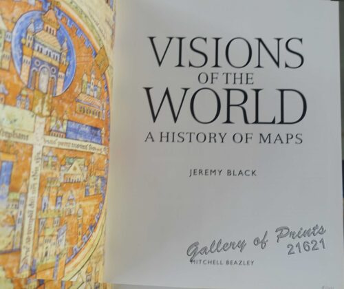
Visions of the World A History of Maps
₱
3,300.00
Add to cart
Details
Vingboons-Atlas
₱
49,500.00
Add to cart
Details
Ville de Manille / De Stad Manilha
₱
26,400.00
Add to cart
Details
Village of San Juento. Manila
₱
6,900.00
Add to cart
Details
Village mandaya (centre Mindanao)
₱
9,900.00
Add to cart
Details
VII. Provintiae seu Belgiu Foederatum exhibita Iohan Michael...
₱
3,300.00
Add to cart
Details
Viajes por Filipinas Reisen in den Philippinen [Travels in...
₱
61,600.00
Add to cart
Details
Viaje a Filipinas. – Moros-Moros, comedia y baile en e...
₱
11,000.00
Add to cart
Details
Viaje a Filipinas – Camino entre San Juan y Quinabla...
₱
11,000.00
Add to cart
Details
Vertooning van de kust vant Eyland Luconia digt by Manila.&#...
₱
15,700.00
Add to cart
Details
Unofficial Letters of an Official’s Wife
₱
13,200.00
Add to cart
Details
Ung habitant de lysle Capul [A native of the island of Capu...
₱
110,000.00
Add to cart
Details
Ung Batteau de Iapan dút Champan [A ship from Japan which t...
₱
50,600.00
Add to cart
Details
Previous
1
2
3
4
5
6
7
…
61
62
63
Next
Shopping Cart
Philippine Islands. Tagolo Point to Cuyo Islands. Including Sebu Negros and Parts of Panay and Palawan. From the United States Coast Survey Charts to 1923.
1
Von den Philippinen: Ansichten von Ilo-Ilo & den Inseln Guimaras und Negros. 1. Landschaft in der Nähe von Ilo-Ilo bei Ebbe und Sonnenuntergang. [Landscape near Ilo-Ilo at Low Tide and Sunset.] 2. Dorf Salog auf Guimaras. [Salog Village in Guimaras.] 3. Ein Dorf auf Negros. [A Village in Negros.]
1
Exposicion de Filipinas en el Parque de Madrid. Interior del Pabellon Estufa........
1
El cochero. [The Coachman]
1
Homebound: Women Visual Artists in Nineteenth Century Philippines.
1
Tradescantia Discolor. Smith. [Spiderwort, Wandering Jew, (Commelinaceae family)]
1
1) Sooloo Riding; 2) Sooloo Arms
1
Manila Harbor Complimentary Map of the City of Manila
1
The Murillo Bulletin, Journal of PHIMCOS, Issue No. 14
1
Carte tres curieuse de la mer du sud, contenant des remarques Nouvelles et tres utiles non Seulement sur les ports et iles de cette mer. [1st and 2nd Sheet] [A Very Special Map of the Southern Sea, Containing New and Very Useful Descriptions not Only of its Ports and Islands.]
1
Battle of Putol fought January 7, 1900 By forces under command of Colonel Wm E. Birkhimer Twenty-Eight Infantry, U. S. Vols. Map of Theater of Operations.
1
[Asia] Asiens Theile seyn: …
1
Chart of Port IloIlo and Panay
1
The Manila Railway Company [1906] Limited. "A" Debenture Bond No. A 12930. £ 100 - with many coupons
1
The Manila Railway Company [1906] Limited 4% "A" Debenture Bond No. A 00000 £ 20 - [with 97 coupons #2-98] [in brown colour]
1
This Earthly Globe: A Venetian Geographer and the Quest to Map the World.
1
Cavite (Islas Filipinas). - La Calle del Arsenal.
1
Village mandaya (centre Mindanao)
1
National Geographic September, 1966, Vol.130, No.3 [The Philippines, Freedom's Pacific Frontier]
1
Caboteur et Pirogues de la Laguna pres de Manille. [Coasters and canoes from La Laguna, near Manila]
1
Homme & Femme des Isles Manilles [Man and Woman from the Manila Islands]
1
Prächtige Paradiesblume. Fig. 1170. [Magnificent Paradise flower]; Stachelige Parkinsonie. Fig. 1171. [Thorny Parkinson]; Westindisches Blutholz. Fig. 1172. [West Indian Bloodwood]; Vielstachelige Caesalpinie. Fig. 1173. [Many-thorned Caesalpinia]
1
Map of the United States showing the Territorial Expansion of a Century 1804 to 1904 insets: 1) The World. 2) Wake Island. 3) Territory of Alaska. 4) Guam Island. 5) Porto Rico. 6) Philippine Islands. 7) Hawaiian Islands. 8) Tutuila, Manua and Smaller Islands of the Samoan Group. 9) Plan of Panama Canal Zone. 10) Plan showing the Thirteen Original States.
1
Exposicion de Filipinas en el Parque de Madrid. 1. Pabellon Flotante para pasear por el lago. 2. Pabellon del Jurado. 3. Operacion de extraer la fibra ....... 4. Tiro de lanza y Ballesta por los Igorrotes. 5. Parque de los Ciervos.
1
Rade de Samboangan [Iles Mandanao] [Sea Front …Zamboanga]
1
A Treaty of Peace Between the United States and Spain. [Message from the President of the United States, A Treaty of Peace Between the United States and Spain, Signed at the City of Paris, on December 10, 1898]… John Hay and William McKinley
1
Sketch of the Engagement of the Prov. Cavalry Brigade. 1st Div. 8th Army Corps Dec 4, 1899. Prepared under the direction of Brig. Genl. S. B. Young.
1
A Boat Girl at Canton
1
Map of the Philippines. Prepared By Reduction From the Map of the Bureau of Insular Affairs, War Department. Relief Compiled from Maps of the Corps of Engineers, US Army, And from Spanish Surveys
1
Philippine Islands. Tagolo Point to Cuyo Islands. Including Sebu , Negros and Parts of Panay and Palawan. From the United States Coast Survey Charts to 1923.
1
Islas Filipinas - Mapa Etnografico pl. 3, Observatorio de Manila
1
[Map of US Military Cables in the Philippines] Manila - Cavite; Taguig - Calamba; Taguig - Biñan; Calamba - Los Baños; Los Baños - Santa Cruz; Cebu - Ormoc
1
Ponte di Manilla
1
The Palace of the Captain-General, on the Pasig River, Manila
1
Cart
Checkout
Continue Shopping
34