Tel : +63(2)-7729-8168 | Mobile: +63 917 806 4291
|
Email: gallery@gop.com.ph
My Account
Remember Me
Register
22 Item(s)
-
₱
411,450.00
River Pasig, from the Citadel, Manila.
1 x
₱
2,200.00
1) Carte des Isles Philippines (1e feuille); 2) Carte des Isles Philippines (2e feuille)
1 x
₱
26,400.00
Panay I. - Port Batan
1 x
₱
4,400.00
1. Vue d'une partie de la côte Nord-Ouest de l'Ile Luçon (Philippines) prise le 20 Décembre 1824 [View of a Section of the Northwest Coast of Luzon Island…]; 2. Vue de Piedra Branca……….Canton…..[China]; 3. Vue de passage de Lantao……….Canton…..[China]; 4. Vue de la Ville de Macao…..[China]; 5. Vue d'une partie de la côte……….Hainan…..[China]; 6. Vue de l'entrée de la baie de Tourane…..[Vietnam]; 7. Vue de mouillage de Tourane…..[Vietnam]; 8. Vue de l'Ile Lombock…..[Indonesia]; 9. Vue de la rade de Sourabaya…..Java…..[Indonesia]; 10. Vue de la Ville de Sidney au …...….[Australia]; 11. Vue de l'entrée ……….Rio Janeiro…..[Brazil]
1 x
₱
11,000.00
The Philippine Insurrection: The Four Truths
1 x
₱
750.00
Collecting Old Maps. Revised and Expanded Edition
1 x
₱
5,900.00
Manille, Pont sur le Passig
1 x
₱
46,200.00
Map of the North Atlantic Ocean showing European Colonial Possessions under their National Flags. 1898. Mercator's Projection
1 x
₱
6,600.00
1) Islas Filipinas 1ª Hoja; 2) Islas Filipinas 2ª Hoja
1 x
₱
39,600.00
Hafen von Hong Kong [Harbour of Hong Kong]
1 x
₱
7,700.00
Map of Northern Luzon Prepared under the direction of Brigadier General S.B.M. Young. U.S.A. Commanding Provisional Cavalry Brigade, Fall Campaign of 1899.
1 x
₱
88,000.00
Philippine Islands. Luzon Island. North of Latitude 16° 20' North. From the United States Cost Survey Charts to 1925.
1 x
₱
11,000.00
The National Geographic Magazine October, 1934, vol. LXVI, No.4
1 x
₱
3,300.00
Rebel Leaders, and Spanish officers in charge of their Deportation from the Islands.
1 x
₱
3,300.00
Le Magasin Pittoresque
1 x
₱
5,500.00
Codiaeum Variegatum. Rump. [English: Croton] [Local Names: San Francisco / Deliciosa]
1 x
₱
26,400.00
Islas Filipinas. - Grupo de Luzon. inset: [Batanes and Babuyan Islands]
1 x
₱
11,000.00
Négritos de la sierra de Marivelès (île de Luçon) (voy. p. 107 et 108)
1 x
₱
6,600.00
The Philippines
1 x
₱
8,800.00
The Philipine Isles
1 x
₱
88,000.00
Bukas I. Port Sibonga
1 x
₱
4,400.00
South Part of Samar
1 x
₱
4,400.00
View Cart
Checkout
Home
About Us
Publications
Shop Online
Framing Services
Exhibits
Picture Hanging System
Contact Us
Blogs
* Price is subject to change without prior notice.
* Objects offered subject unsold.
View cart
You cannot add another "South Part of Samar" to your cart.
View cart
“South Part of Samar” has been added to your cart.
Sort by
Date
Sort by
Default Order
Sort by
Name
Sort by
Price
Sort by
Date
Sort by
Popularity
Show
30 Products
Show
30 Products
Show
60 Products
Show
90 Products
Manila Harbor Complimentary Map of the City of Manila
₱
22,000.00
Add to cart
Details
The Mapping of the Heavens
₱
1,980.00
Add to cart
Details
Philippines
₱
8,800.00
Add to cart
Details
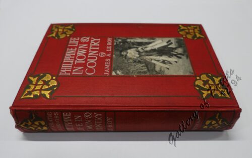
Philippine Life in Town & Country.
₱
8,800.00
Add to cart
Details
Rizal
₱
17,600.00
Add to cart
Details
Bohol
₱
17,600.00
Add to cart
Details
Leyte
₱
17,600.00
Add to cart
Details
Zambales
₱
17,600.00
Add to cart
Details
Map of Pacific Ocean by Robinson H. E. C. Pty. Ltd. Mercat...
₱
14,700.00
Add to cart
Details
South Island New Zealand
₱
4,400.00
Add to cart
Details
Northern Island New Zealand
₱
4,400.00
Add to cart
Details
The Mysteries of Taal: A Philippine Volcano and Lake, Her S...
₱
900.00
Add to cart
Details
Iloilo A Rich and Noble Land
₱
7,500.00
Add to cart
Details
When Britain Ruled the Philippines 1762-1764
₱
2,200.00
Add to cart
Details
Spanish Galleon 1530 – 1690 New Vanguard # 96
₱
2,200.00
Add to cart
Details
The Manila-Acapulco Galleons: The Treasure Ships of the Paci...
₱
4,400.00
Add to cart
Details
The National Geographic Magazine September, 1952, vol. CII, ...
₱
1,100.00
Add to cart
Details
Sale!
Karte der St. Gotthard-Bahn, Taf.2 [Map of The Gotthard-Rail...
₱
6,600.00
₱
5,280.00
Add to cart
Details
The Far East Compiled and Drawn in the Cartographic Section ...
₱
6,600.00
Add to cart
Details
Philippine Religious – Carvings in Ivory
₱
2,500.00
Add to cart
Details
Filipino Master – Damian Domingo
₱
2,500.00
Add to cart
Details
The Age of Trade The Manila Galleons and the Dawn of the Glo...
₱
6,600.00
Add to cart
Details
Adios, Patria Adorada [The Filipino as Ilustrado, The Ilustr...
₱
990.00
Add to cart
Details
Blue Book of the First Year of the Republic of the Philippin...
₱
24,500.00
Add to cart
Details
Evangelización de Filipinas y del Japon Historia de las Isl...
₱
2,200.00
Add to cart
Details
The Golden Atlas: The Greatest Explorations, Quests and Dis...
₱
3,300.00
Add to cart
Details
Early Mapping of the Pacific The Epic Story of Seafarers, Ad...
₱
6,600.00
Add to cart
Details
Early Maps of South-East Asia
₱
4,400.00
Add to cart
Details
Hinter-Indien und Ostindische Inseln. [Farther India and Eas...
₱
8,800.00
Add to cart
Details
Southeast Asia and Pacific Islands from the Indies and the ...
₱
4,400.00
Add to cart
Details
1
2
3
4
…
61
62
63
Next
Shopping Cart
South Part of Samar
1
Bukas I. Port Sibonga
1
The Philipine Isles
1
The Philippines
1
Négritos de la sierra de Marivelès (île de Luçon) (voy. p. 107 et 108)
1
Islas Filipinas. - Grupo de Luzon. inset: [Batanes and Babuyan Islands]
1
Codiaeum Variegatum. Rump. [English: Croton] [Local Names: San Francisco / Deliciosa]
1
Le Magasin Pittoresque
1
Rebel Leaders, and Spanish officers in charge of their Deportation from the Islands.
1
The National Geographic Magazine October, 1934, vol. LXVI, No.4
1
Philippine Islands. Luzon Island. North of Latitude 16° 20' North. From the United States Cost Survey Charts to 1925.
1
Map of Northern Luzon Prepared under the direction of Brigadier General S.B.M. Young. U.S.A. Commanding Provisional Cavalry Brigade, Fall Campaign of 1899.
1
Hafen von Hong Kong [Harbour of Hong Kong]
1
1) Islas Filipinas 1ª Hoja; 2) Islas Filipinas 2ª Hoja
1
Map of the North Atlantic Ocean showing European Colonial Possessions under their National Flags. 1898. Mercator's Projection
1
Manille, Pont sur le Passig
1
Collecting Old Maps. Revised and Expanded Edition
1
The Philippine Insurrection: The Four Truths
1
1. Vue d'une partie de la côte Nord-Ouest de l'Ile Luçon (Philippines) prise le 20 Décembre 1824 [View of a Section of the Northwest Coast of Luzon Island…]; 2. Vue de Piedra Branca……….Canton…..[China]; 3. Vue de passage de Lantao……….Canton…..[China]; 4. Vue de la Ville de Macao…..[China]; 5. Vue d'une partie de la côte……….Hainan…..[China]; 6. Vue de l'entrée de la baie de Tourane…..[Vietnam]; 7. Vue de mouillage de Tourane…..[Vietnam]; 8. Vue de l'Ile Lombock…..[Indonesia]; 9. Vue de la rade de Sourabaya…..Java…..[Indonesia]; 10. Vue de la Ville de Sidney au …...….[Australia]; 11. Vue de l'entrée ……….Rio Janeiro…..[Brazil]
1
Panay I. - Port Batan
1
1) Carte des Isles Philippines (1e feuille); 2) Carte des Isles Philippines (2e feuille)
1
River Pasig, from the Citadel, Manila.
1
Cart
Checkout
Continue Shopping
22