Tel : +63(2)-7729-8168 | Mobile: +63 917 806 4291
|
Email: gallery@gop.com.ph
My Account
Remember Me
Register
14 Item(s)
-
₱
218,610.00
Map of the China Seas showing Philippine Islands and Adjacent Countries with European Colonial Possessions under their National Flags. 1898. Mercator's Projection
1 x
₱
6,600.00
Leyte
1 x
₱
17,600.00
Map of the Philippines. Prepared By Reduction From the Map of the Bureau of Insular Affairs, War Department. Relief Compiled from Maps of the Corps of Engineers, US Army, And from Spanish Surveys.
1 x
₱
13,200.00
Map of Batan Island
1 x
₱
6,600.00
The Murillo Bulletin, Journal of PHIMCOS, Issue No.3
1 x
₱
450.00
Fève De St. Ignace. [Jesuit Bean / Aguwason] [Strychnos ignati]
1 x
₱
6,600.00
Islas Filipinas. Division territorial moderna 1879. por Manuel Scheidnagel.
1 x
₱
88,000.00
1) Merops Bicolor [Rufous-crowned Bee-eater]; 2) Merops Sumatranus [Blue-throated Bee-eater]
1 x
₱
14,960.00
The Philippines: A Summary Account of their Ethnographical, Historical and Political Conditions [translation of “Die Philippinen. Eine übersichtliche Darstellung der ethnographischen und historisch=politischen Verhältnisse des Archipels” with an Appendix containing The Constitution of the Philippine Republic [translation of “Mit einem Anhange – Die wichtigsten Paragraphen der Verfassung der philippinischen Republik.”
1 x
₱
2,500.00
En el archipiélago de la Especiería España y Molucas en los siglos XVI y XVII [In the Spanish Spice Archipelago and Moluccas in the 16th and 17th Centuries]
1 x
₱
4,900.00
Thresoor der Zeevaert
1 x
₱
6,600.00
Pinus Taeda?- Blanco. Pinus Insularis: Endl.- Llanos - DC. [Local Name: Baguio Pine]
1 x
₱
39,600.00
The Harbour, Manila.
1 x
₱
6,600.00
Bukas I. Port Sibonga
1 x
₱
4,400.00
View Cart
Checkout
Home
About Us
Publications
Shop Online
Framing Services
Exhibits
Picture Hanging System
Contact Us
Blogs
* Price is subject to change without prior notice.
* Objects offered subject unsold.
View cart
You cannot add another "Bukas I. Port Sibonga" to your cart.
View cart
“Bukas I. Port Sibonga” has been added to your cart.
Sort by
Date
Sort by
Default Order
Sort by
Name
Sort by
Price
Sort by
Date
Sort by
Popularity
Show
30 Products
Show
30 Products
Show
60 Products
Show
90 Products
Manila Harbor Complimentary Map of the City of Manila
₱
22,000.00
Add to cart
Details
The Mapping of the Heavens
₱
1,980.00
Add to cart
Details
Philippines
₱
8,800.00
Add to cart
Details
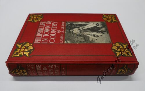
Philippine Life in Town & Country.
₱
8,800.00
Add to cart
Details
Rizal
₱
17,600.00
Add to cart
Details
Bohol
₱
17,600.00
Add to cart
Details
Leyte
₱
17,600.00
Add to cart
Details
Zambales
₱
17,600.00
Add to cart
Details
Map of Pacific Ocean by Robinson H. E. C. Pty. Ltd. Mercat...
₱
14,700.00
Add to cart
Details
South Island New Zealand
₱
4,400.00
Add to cart
Details
Northern Island New Zealand
₱
4,400.00
Add to cart
Details
The Mysteries of Taal: A Philippine Volcano and Lake, Her S...
₱
900.00
Add to cart
Details
Iloilo A Rich and Noble Land
₱
7,500.00
Add to cart
Details
When Britain Ruled the Philippines 1762-1764
₱
2,200.00
Add to cart
Details
Spanish Galleon 1530 – 1690 New Vanguard # 96
₱
2,200.00
Add to cart
Details
The Manila-Acapulco Galleons: The Treasure Ships of the Paci...
₱
4,400.00
Add to cart
Details
The National Geographic Magazine September, 1952, vol. CII, ...
₱
1,100.00
Add to cart
Details
Sale!
Karte der St. Gotthard-Bahn, Taf.2 [Map of The Gotthard-Rail...
₱
6,600.00
₱
5,280.00
Add to cart
Details
The Far East Compiled and Drawn in the Cartographic Section ...
₱
6,600.00
Add to cart
Details
Philippine Religious – Carvings in Ivory
₱
2,500.00
Add to cart
Details
Filipino Master – Damian Domingo
₱
2,500.00
Add to cart
Details
The Age of Trade The Manila Galleons and the Dawn of the Glo...
₱
6,600.00
Add to cart
Details
Adios, Patria Adorada [The Filipino as Ilustrado, The Ilustr...
₱
990.00
Add to cart
Details
Blue Book of the First Year of the Republic of the Philippin...
₱
24,500.00
Add to cart
Details
Evangelización de Filipinas y del Japon Historia de las Isl...
₱
2,200.00
Add to cart
Details
The Golden Atlas: The Greatest Explorations, Quests and Dis...
₱
3,300.00
Add to cart
Details
Early Mapping of the Pacific The Epic Story of Seafarers, Ad...
₱
6,600.00
Add to cart
Details
Early Maps of South-East Asia
₱
4,400.00
Add to cart
Details
Hinter-Indien und Ostindische Inseln. [Farther India and Eas...
₱
8,800.00
Add to cart
Details
Southeast Asia and Pacific Islands from the Indies and the ...
₱
4,400.00
Add to cart
Details
Habts. des iles Philippines. [Inhabitants of the Philippine...
₱
6,600.00
Add to cart
Details
Num. 18201 Accion de doscientos cincuenta Pesos … [Share o...
₱
50,600.00
Add to cart
Details
Explorers’ Sketchbooks The Art of Discovery & Adve...
₱
3,300.00
Add to cart
Details
The Voyage of the Frigate Pallada [1852-1855]
₱
3,300.00
Add to cart
Details
War Map Pictorial conflict Maps 1900-1950
₱
4,400.00
Add to cart
Details
Maps & Civilization: Cartography in Culture and Society....
₱
2,200.00
Add to cart
Details
The Phantom Atlas The Greatest Myths, Lies and Blunders on M...
₱
3,300.00
Add to cart
Details
A History of the 20th Century in 100 Maps
₱
3,300.00
Add to cart
Details
Ozeanische Kunst [Art of Oceania]
₱
4,400.00
Add to cart
Details
A Treaty of Peace Between the United States and Spain. [Mess...
₱
9,900.00
Add to cart
Details
The Phantom Atlas The Greatest Myths, Lies and Blunders on M...
₱
3,300.00
Add to cart
Details
The Book of Flowers
₱
8,800.00
Add to cart
Details
The Chatelain Atlas
₱
500.00
Add to cart
Details
The Mapmaker’s Art (A History of Cartography)
₱
9,900.00
Add to cart
Details
Maps & Prints for pleasure and investment.
₱
2,500.00
Add to cart
Details
National Geographic March, 1977, Vol.151, No.3 [The Philippi...
₱
1,200.00
Add to cart
Details
National Geographic August, 1972, Vol.142, No.2 [The Tasaday...
₱
1,200.00
Add to cart
Details
The History of Seafaring: Navigating the World’s Ocean...
₱
5,040.00
Add to cart
Details
Japan A Cartographic Vision
₱
4,400.00
Add to cart
Details
The Philippine Islands
₱
16,700.00
Add to cart
Details
Ortelius Atlas Maps 2nd revised edition
₱
5,500.00
Add to cart
Details
The Mapping of Terra Australis
₱
5,500.00
Add to cart
Details
Bel et Utile: The Work of the Robert de Vaugondy Family of M...
₱
6,600.00
Add to cart
Details
Mercator The Man Who Mapped The Planet.
₱
2,200.00
Add to cart
Details
The Atlas of Atlases
₱
4,400.00
Add to cart
Details
Magnificent Maps, Power, Propaganda and Art.
₱
2,200.00
Add to cart
Details
Travel Accounts of the Islands (1513-1787)
₱
6,600.00
Add to cart
Details
Occupied Philippines The Role of Jorge B. Vargas during the ...
₱
4,400.00
Add to cart
Details
Mapping the World, An Illustrated History of Cartography.
₱
3,300.00
Add to cart
Details
The Man Who Invented History: Travels with Herodotus.
₱
3,300.00
Add to cart
Details
1
2
3
4
…
30
31
32
Next
Shopping Cart
Bukas I. Port Sibonga
1
The Harbour, Manila.
1
Pinus Taeda?- Blanco. Pinus Insularis: Endl.- Llanos - DC. [Local Name: Baguio Pine]
1
Thresoor der Zeevaert
1
En el archipiélago de la Especiería España y Molucas en los siglos XVI y XVII [In the Spanish Spice Archipelago and Moluccas in the 16th and 17th Centuries]
1
The Philippines: A Summary Account of their Ethnographical, Historical and Political Conditions [translation of “Die Philippinen. Eine übersichtliche Darstellung der ethnographischen und historisch=politischen Verhältnisse des Archipels” with an Appendix containing The Constitution of the Philippine Republic [translation of “Mit einem Anhange – Die wichtigsten Paragraphen der Verfassung der philippinischen Republik.”
1
1) Merops Bicolor [Rufous-crowned Bee-eater]; 2) Merops Sumatranus [Blue-throated Bee-eater]
1
Islas Filipinas. Division territorial moderna 1879. por Manuel Scheidnagel.
1
Fève De St. Ignace. [Jesuit Bean / Aguwason] [Strychnos ignati]
1
The Murillo Bulletin, Journal of PHIMCOS, Issue No.3
-
Quantity
+
Map of Batan Island
1
Map of the Philippines. Prepared By Reduction From the Map of the Bureau of Insular Affairs, War Department. Relief Compiled from Maps of the Corps of Engineers, US Army, And from Spanish Surveys.
1
Leyte
1
Map of the China Seas showing Philippine Islands and Adjacent Countries with European Colonial Possessions under their National Flags. 1898. Mercator's Projection
1
Cart
Checkout
Continue Shopping
14