Tel : +63(2)-7729-8168 | Mobile: +63 917 806 4291
|
Email: gallery@gop.com.ph
My Account
Remember Me
Register
23 Item(s)
-
₱
552,550.00
Indiae Orientalis insularumque adiacientium typus
1 x
₱
156,000.00
Bilalo, bateau de passage de Manille a Cavite. [Manila-Cavite ferry, called a "Bilalo"]
1 x
₱
110,000.00
Route entre San Juan et Quinablangan
1 x
₱
7,700.00
China in Those Days. Insights into Historical China through Postcards of the Time
1 x
₱
7,700.00
A Chart of the Pacific Ocean from the Equinoctial to the Latitude of 39 1/2 d. No
1 x
₱
15,400.00
A New Map of the Philippine Islands, Drawn from the best Authorities
1 x
₱
49,500.00
Lagerstroemia Regia. Roxb. [Tagalog: Banaba Tree]
1 x
₱
26,400.00
The Book of Flowers
1 x
₱
8,800.00
Stacking Rice, Luzon
1 x
₱
5,500.00
Manilla Banca
1 x
₱
5,500.00
Ladmiral surmonte s'en allant au fond a nostre veúe
1 x
₱
49,600.00
Archipiélago Filipino - Isla de Mindanao Plano del Puerto de Pollok
1 x
₱
4,400.00
1. Manilla Woman: Walking Dress; 2. Manilla Girl: Indoor Dress; 3. Manilla: A Banca Party
1 x
₱
9,900.00
Der grosschuppige Drachenkopf - Scorpaena scrofa. LaGrabbe de Biarrits. [The Large-Scaled Scorpion Fish]
1 x
₱
4,400.00
The National Geographic Magazine September, 1937, vol. LXXII, No.3
1 x
₱
3,300.00
Philippine Islands. Tagolo Point to Cuyo Islands. Including Sebu , Negros and Parts of Panay and Palawan. From the United States Coast Survey Charts to 1923.
1 x
₱
11,000.00
Anchorages of Luzon, Mindoro and Marinduque. insets: 1) Luzon - West Coast. Bolinao Harbour. From the United States Government Survey of 1904. With additions and corrections from Philippine Gov't. Charts to 1964. 2) Luzon - West Coast. Port Masinloc and Port Matalvi. From the United States Government Surveys of 1937. With additions and corrections from Philippine Gov't. Charts to 1964. 3) Luzon - West Coast. Mariveles Harbour. From the United States Government Chart of 1940. With additions and corrections from Philippine Gov't. Charts to 1964. 4) Luzon - South - West Coast. Batangas. From the Philippine Government Chart of 1956. With additions and corrections to 1964. 5) Luzon - South - West Coast. Nasugbu Bay. From the Philippine Government Chart of 1956. 6) Marinduque. Port Balanacan. From the United States Government Survey of 1908. With additions and corrections from Philippine Gov't. Charts to 1964. 7) Marinduque. Santa Cruz Harbour. From the United States Government Survey of 1908. With additions and corrections from Philippine Gov't. Charts to 1964. 8) Mindoro - North Coast. Port Galera and Varadero Bay. From the United States Government Surveys to 1939. With additions and corrections from Philippine Gov't. Charts to 1964.
1 x
₱
11,000.00
Plantation du riz en cadence par les Tagalocs [Tagalogs Planting Rice in Musical Tact]
1 x
₱
4,400.00
A Map of the East India Islands, agreeable to the most approved Maps and Charts, By Tho.s Conder.
1 x
₱
22,000.00
Port of Manila, Trade Center of the Pacific. Year Book 1933
1 x
₱
7,700.00
The Murillo Bulletin, Journal of PHIMCOS, Issue No.3
1 x
₱
450.00
Islas Filipinas - Mapa General pl. 2, Observatorio de Manila
1 x
₱
5,500.00
Vue de Sambouangue [View of Zamboanga]
1 x
₱
26,400.00
View Cart
Checkout
Home
About Us
Publications
Shop Online
Framing Services
Exhibits
Picture Hanging System
Contact Us
Blogs
View cart
“Vue de Sambouangue [View of Zamboanga]” has been added to your cart.
Sort by
Price
Sort by
Default Order
Sort by
Name
Sort by
Price
Sort by
Date
Sort by
Popularity
Show
30 Products
Show
30 Products
Show
60 Products
Show
90 Products
Magsaysay of the Philippines
₱
7,700.00
Add to cart
Details
Palestina in XII. Tribus divisa Iohann Michael Probst excudi...
₱
7,850.00
Add to cart
Details
America Septentrionalis Coloniis in Interiorem Virginiam ded...
₱
7,850.00
Add to cart
Details
Planisphaerium. Coeleste. Verlegt von I.M. Probst 1780
₱
7,850.00
Add to cart
Details
Mittheilungen aus Justus Perthes’ Geographischer Ansta...
₱
8,000.00
Add to cart
Details
Mittheilungen aus Justus Perthes’ Geographischer Ansta...
₱
8,000.00
Add to cart
Details
Mittheilungen aus Justus Perthes’ Geographischer Ansta...
₱
8,600.00
Add to cart
Details
Mittheilungen aus Justus Perthes’ Geographischer Ansta...
₱
8,600.00
Add to cart
Details
Mittheilungen aus Justus Perthes’ Geographischer Ansta...
₱
8,600.00
Add to cart
Details
Sketches in Manilla. 1. Barber’s shop in Manilla; 2. S...
₱
8,800.00
Add to cart
Details
Interior of the Crater of the Volcano at Taal
₱
8,800.00
Add to cart
Details
Soirée d’une famille tagale
₱
8,800.00
Add to cart
Details
Ein Tagalendorf auf Luzon. (Nach der Natur) [Tagal Village i...
₱
8,800.00
Add to cart
Details
Panorama des Taal-Gebietes. von der Spitze des Maquiling [Pa...
₱
8,800.00
Add to cart
Details
1. Vue Generale de Manille; 2. Nuestro Senor ……&...
₱
8,800.00
Add to cart
Details
España, sus monumentos y artes, su naturaleza e historia. C...
₱
8,800.00
Add to cart
Details
Filipinas. 1) Filipinas. – Mujer Indigena. 2) Filipina...
₱
8,800.00
Add to cart
Details
Ostindische Inseln (Spezialkarten)
₱
8,800.00
Add to cart
Details
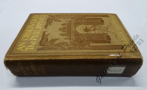
An Observer in the Philippines or Life in Our New Possession...
₱
8,800.00
Add to cart
Details
MADRID. – Exposicion de Filipinas: Exterior de los edi...
₱
8,800.00
Add to cart
Details
Campagne des Environs de Manille (Oceanie) [Countryside near...
₱
8,800.00
Add to cart
Details
Philippines. Propriete de Mr. La Geroniere
₱
8,800.00
Add to cart
Details
R. valentinianum [Rhododendron valentinianum, bright yellow ...
₱
8,800.00
Add to cart
Details
Sketches from Manilla and Hongkong 1. “Our Street̶...
₱
8,800.00
Add to cart
Details
Tipos Filipinos. 1. Gobernadorcillo 2. Chino cargador de a...
₱
8,800.00
Add to cart
Details
The Philippines- Our Artist with the Firing-Line during the ...
₱
8,800.00
Add to cart
Details
The Philippines- Our Artist with the Firing-Line during the ...
₱
8,800.00
Add to cart
Details
The Philippines
₱
8,800.00
Add to cart
Details
Philippine Islands
₱
8,800.00
Add to cart
Details
La Révolte aux Philippines – Voir page 798 1. Cathéd...
₱
8,800.00
Add to cart
Details
Previous
1
2
3
…
34
35
36
37
38
39
40
…
61
62
63
Next
Shopping Cart
Vue de Sambouangue [View of Zamboanga]
1
Islas Filipinas - Mapa General pl. 2, Observatorio de Manila
1
The Murillo Bulletin, Journal of PHIMCOS, Issue No.3
-
Quantity
+
Port of Manila, Trade Center of the Pacific. Year Book 1933
1
A Map of the East India Islands, agreeable to the most approved Maps and Charts, By Tho.s Conder.
1
Plantation du riz en cadence par les Tagalocs [Tagalogs Planting Rice in Musical Tact]
1
Anchorages of Luzon, Mindoro and Marinduque. insets: 1) Luzon - West Coast. Bolinao Harbour. From the United States Government Survey of 1904. With additions and corrections from Philippine Gov't. Charts to 1964. 2) Luzon - West Coast. Port Masinloc and Port Matalvi. From the United States Government Surveys of 1937. With additions and corrections from Philippine Gov't. Charts to 1964. 3) Luzon - West Coast. Mariveles Harbour. From the United States Government Chart of 1940. With additions and corrections from Philippine Gov't. Charts to 1964. 4) Luzon - South - West Coast. Batangas. From the Philippine Government Chart of 1956. With additions and corrections to 1964. 5) Luzon - South - West Coast. Nasugbu Bay. From the Philippine Government Chart of 1956. 6) Marinduque. Port Balanacan. From the United States Government Survey of 1908. With additions and corrections from Philippine Gov't. Charts to 1964. 7) Marinduque. Santa Cruz Harbour. From the United States Government Survey of 1908. With additions and corrections from Philippine Gov't. Charts to 1964. 8) Mindoro - North Coast. Port Galera and Varadero Bay. From the United States Government Surveys to 1939. With additions and corrections from Philippine Gov't. Charts to 1964.
1
Philippine Islands. Tagolo Point to Cuyo Islands. Including Sebu , Negros and Parts of Panay and Palawan. From the United States Coast Survey Charts to 1923.
1
The National Geographic Magazine September, 1937, vol. LXXII, No.3
1
Der grosschuppige Drachenkopf - Scorpaena scrofa. LaGrabbe de Biarrits. [The Large-Scaled Scorpion Fish]
1
1. Manilla Woman: Walking Dress; 2. Manilla Girl: Indoor Dress; 3. Manilla: A Banca Party
1
Archipiélago Filipino - Isla de Mindanao Plano del Puerto de Pollok
1
Ladmiral surmonte s'en allant au fond a nostre veúe
1
Manilla Banca
1
Stacking Rice, Luzon
1
The Book of Flowers
1
Lagerstroemia Regia. Roxb. [Tagalog: Banaba Tree]
1
A New Map of the Philippine Islands, Drawn from the best Authorities
1
A Chart of the Pacific Ocean from the Equinoctial to the Latitude of 39 1/2 d. No
1
China in Those Days. Insights into Historical China through Postcards of the Time
1
Route entre San Juan et Quinablangan
1
Bilalo, bateau de passage de Manille a Cavite. [Manila-Cavite ferry, called a "Bilalo"]
1
Indiae Orientalis insularumque adiacientium typus
1
Cart
Checkout
Continue Shopping
23