Tel : +63(2)-7729-8168 | Mobile: +63 917 806 4291
|
Email: gallery@gop.com.ph
My Account
Remember Me
Register
24 Item(s)
-
₱
510,050.00
Carte des Indes Orientales... (1e et 2e feuille)
1 x
₱
62,850.00
The Earthquake at Manilla: 3 views. 1) Nave of the Cathedral after the Earthquake. 2) Tower of Binondo Church after the Earthquake. 3) Ruins of the Danish Consulate
1 x
₱
8,800.00
Cochinchine - Philippines 1. Femmes Cochinchinoises. 2. Tagals
1 x
₱
39,600.00
Ports Subic and Silanguin. From Spanish Government Surveys 1885 & 1891
1 x
₱
9,900.00
Anchorages of Luzon, Mindoro and Marinduque. insets: 1) Luzon - West Coast. Bolinao Harbour. From the United States Government Survey of 1904. With additions and corrections from Philippine Gov't. Charts to 1964. 2) Luzon - West Coast. Port Masinloc and Port Matalvi. From the United States Government Surveys of 1937. With additions and corrections from Philippine Gov't. Charts to 1964. 3) Luzon - West Coast. Mariveles Harbour. From the United States Government Chart of 1940. With additions and corrections from Philippine Gov't. Charts to 1964. 4) Luzon - South - West Coast. Batangas. From the Philippine Government Chart of 1956. With additions and corrections to 1964. 5) Luzon - South - West Coast. Nasugbu Bay. From the Philippine Government Chart of 1956. 6) Marinduque. Port Balanacan. From the United States Government Survey of 1908. With additions and corrections from Philippine Gov't. Charts to 1964. 7) Marinduque. Santa Cruz Harbour. From the United States Government Survey of 1908. With additions and corrections from Philippine Gov't. Charts to 1964. 8) Mindoro - North Coast. Port Galera and Varadero Bay. From the United States Government Surveys to 1939. With additions and corrections from Philippine Gov't. Charts to 1964.
1 x
₱
11,000.00
Pioneers of the Pacific: Voyages of Exploration, 1787-1810
1 x
₱
2,200.00
Épisode de l'attaque des juramentados
1 x
₱
4,400.00
Itinéraire de l'ascension de l'Apó;… {Itinerary of the Mount Apo Conquest]
1 x
₱
6,600.00
Antique Maps - Christie's Collectors Guide
1 x
₱
2,500.00
Decorative Printed Maps of the 15th to 18th Centuries
1 x
₱
3,300.00
Map Showing Operations in the Provinces of North and South Camarines Luzon. P.I. under the direction of Maj. Gen. Bates. (Bell's Exfeditionary Brigade) Feb'y and Mar. 1900. inset: [Albay]
1 x
₱
7,700.00
East Indies from the Best Authorities
1 x
₱
13,200.00
Marché de Maïbun [Maïbun Market]
1 x
₱
4,400.00
Map Showing Operations Provisional Brigade - 1st Division from October 7th to 15th 1899. Brig. General Theodore Schwan commanding. Prepared under direction of General Schwan by Wm L. Sibert, Captain of Engineers, Chief Engineer.
1 x
₱
9,900.00
Eastern Passages to China Sheet III. inset: Plan of Manilla Bay, surveyed in 1792 by Don Felipe Bauza. [Eastern Philippines]
1 x
₱
99,000.00
The Philipine Isles
1 x
₱
77,000.00
'XIV. Von Schanghai nach Guaham und Puynipet. [Carolinen Archipel].
1 x
₱
3,300.00
Vue de Sambouangue [View of Zamboanga]
1 x
₱
26,400.00
Manila And Its Surroundings
1 x
₱
18,700.00
The Philippines. It's Not-So-Far East on Northwest. Northwest Orient.
1 x
₱
26,400.00
Stacking Rice, Luzon
1 x
₱
5,500.00
Admiral George Dewey, U.S.N. From His latest photograph, taken on board the flag-ship "Olympia," Manila.
1 x
₱
13,200.00
AAF Cloth Chart - Philippine Series No. C-41, Mindoro Island [Mindoro & Palawan Islands, Sulu Sea] inset: [Palawan] No. C-42, Samar Island [VERSO] [South Luzon, Samar & Visayan Islands]
1 x
₱
46,500.00
Oriental Islands.
1 x
₱
7,700.00
View Cart
Checkout
Home
About Us
Publications
Shop Online
Framing Services
Exhibits
Picture Hanging System
Contact Us
Blogs
View cart
“Oriental Islands.” has been added to your cart.
Sort by
Popularity
Sort by
Default Order
Sort by
Name
Sort by
Price
Sort by
Date
Sort by
Popularity
Show
30 Products
Show
30 Products
Show
60 Products
Show
90 Products
Philippines
₱
8,800.00
Add to cart
Details
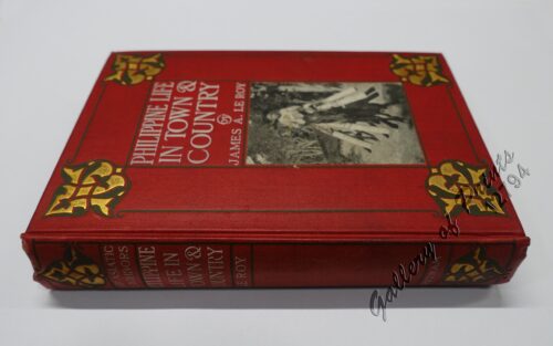
Philippine Life in Town & Country.
₱
8,800.00
Add to cart
Details
Rizal
₱
17,600.00
Add to cart
Details
Bohol
₱
17,600.00
Add to cart
Details
Leyte
₱
17,600.00
Add to cart
Details
Zambales
₱
17,600.00
Add to cart
Details
Map of Pacific Ocean by Robinson H. E. C. Pty. Ltd. Mercat...
₱
14,700.00
Add to cart
Details
South Island New Zealand
₱
4,400.00
Add to cart
Details
Northern Island New Zealand
₱
4,400.00
Add to cart
Details
The Mysteries of Taal: A Philippine Volcano and Lake, Her S...
₱
900.00
Add to cart
Details
Iloilo A Rich and Noble Land
₱
7,500.00
Add to cart
Details
When Britain Ruled the Philippines 1762-1764
₱
2,200.00
Add to cart
Details
Spanish Galleon 1530 – 1690 New Vanguard # 96
₱
2,200.00
Add to cart
Details
The Manila-Acapulco Galleons: The Treasure Ships of the Paci...
₱
4,400.00
Add to cart
Details
The National Geographic Magazine September, 1952, vol. CII, ...
₱
1,100.00
Add to cart
Details
Karte der St. Gotthard-Bahn, Taf.2 [Map of The Gotthard-Rail...
₱
6,600.00
Add to cart
Details
The Far East Compiled and Drawn in the Cartographic Section ...
₱
6,600.00
Add to cart
Details
Philippine Religious – Carvings in Ivory
₱
2,500.00
Add to cart
Details
Filipino Master – Damian Domingo
₱
2,500.00
Add to cart
Details
The Age of Trade The Manila Galleons and the Dawn of the Glo...
₱
6,600.00
Add to cart
Details
Adios, Patria Adorada [The Filipino as Ilustrado, The Ilustr...
₱
990.00
Add to cart
Details
Blue Book of the First Year of the Republic of the Philippin...
₱
24,500.00
Add to cart
Details
Evangelización de Filipinas y del Japon Historia de las Isl...
₱
2,200.00
Add to cart
Details
The Golden Atlas: The Greatest Explorations, Quests and Dis...
₱
3,300.00
Add to cart
Details
Early Mapping of the Pacific The Epic Story of Seafarers, Ad...
₱
6,600.00
Add to cart
Details
Early Maps of South-East Asia
₱
4,400.00
Add to cart
Details
Hinter-Indien und Ostindische Inseln. [Farther India and Eas...
₱
8,800.00
Add to cart
Details
Southeast Asia and Pacific Islands from the Indies and the ...
₱
4,400.00
Add to cart
Details
Habts. des iles Philippines. [Inhabitants of the Philippine...
₱
6,600.00
Add to cart
Details
Num. 18201 Accion de doscientos cincuenta Pesos … [Share o...
₱
50,600.00
Add to cart
Details
Previous
1
2
3
4
5
6
…
61
62
63
Next
Shopping Cart
Oriental Islands.
1
AAF Cloth Chart - Philippine Series No. C-41, Mindoro Island [Mindoro & Palawan Islands, Sulu Sea] inset: [Palawan] No. C-42, Samar Island [VERSO] [South Luzon, Samar & Visayan Islands]
1
Admiral George Dewey, U.S.N. From His latest photograph, taken on board the flag-ship "Olympia," Manila.
1
Stacking Rice, Luzon
1
The Philippines. It's Not-So-Far East on Northwest. Northwest Orient.
1
Manila And Its Surroundings
1
Vue de Sambouangue [View of Zamboanga]
1
'XIV. Von Schanghai nach Guaham und Puynipet. [Carolinen Archipel].
1
The Philipine Isles
1
Eastern Passages to China Sheet III. inset: Plan of Manilla Bay, surveyed in 1792 by Don Felipe Bauza. [Eastern Philippines]
1
Map Showing Operations Provisional Brigade - 1st Division from October 7th to 15th 1899. Brig. General Theodore Schwan commanding. Prepared under direction of General Schwan by Wm L. Sibert, Captain of Engineers, Chief Engineer.
1
Marché de Maïbun [Maïbun Market]
1
East Indies from the Best Authorities
1
Map Showing Operations in the Provinces of North and South Camarines Luzon. P.I. under the direction of Maj. Gen. Bates. (Bell's Exfeditionary Brigade) Feb'y and Mar. 1900. inset: [Albay]
1
Decorative Printed Maps of the 15th to 18th Centuries
1
Antique Maps - Christie's Collectors Guide
1
Itinéraire de l'ascension de l'Apó;… {Itinerary of the Mount Apo Conquest]
1
Épisode de l'attaque des juramentados
1
Pioneers of the Pacific: Voyages of Exploration, 1787-1810
1
Anchorages of Luzon, Mindoro and Marinduque. insets: 1) Luzon - West Coast. Bolinao Harbour. From the United States Government Survey of 1904. With additions and corrections from Philippine Gov't. Charts to 1964. 2) Luzon - West Coast. Port Masinloc and Port Matalvi. From the United States Government Surveys of 1937. With additions and corrections from Philippine Gov't. Charts to 1964. 3) Luzon - West Coast. Mariveles Harbour. From the United States Government Chart of 1940. With additions and corrections from Philippine Gov't. Charts to 1964. 4) Luzon - South - West Coast. Batangas. From the Philippine Government Chart of 1956. With additions and corrections to 1964. 5) Luzon - South - West Coast. Nasugbu Bay. From the Philippine Government Chart of 1956. 6) Marinduque. Port Balanacan. From the United States Government Survey of 1908. With additions and corrections from Philippine Gov't. Charts to 1964. 7) Marinduque. Santa Cruz Harbour. From the United States Government Survey of 1908. With additions and corrections from Philippine Gov't. Charts to 1964. 8) Mindoro - North Coast. Port Galera and Varadero Bay. From the United States Government Surveys to 1939. With additions and corrections from Philippine Gov't. Charts to 1964.
1
Ports Subic and Silanguin. From Spanish Government Surveys 1885 & 1891
1
Cochinchine - Philippines 1. Femmes Cochinchinoises. 2. Tagals
1
The Earthquake at Manilla: 3 views. 1) Nave of the Cathedral after the Earthquake. 2) Tower of Binondo Church after the Earthquake. 3) Ruins of the Danish Consulate
1
Carte des Indes Orientales... (1e et 2e feuille)
1
Cart
Checkout
Continue Shopping
24