Tel : +63(2)-7729-8168 | Mobile: +63 917 806 4291
|
Email: gallery@gop.com.ph
My Account
Remember Me
Register
22 Item(s)
-
₱
478,100.00
Cycas Circinalis [Sage Palm Tree]
1 x
₱
7,700.00
Saxifraga Purpurascens. [Purple Himalayan Saxifrage] [Purple Bergenia]
1 x
₱
6,600.00
Dr. A. Petermann's Mittheilungen aus Justus Perthes' Geographischer Anstalt. Herausgegeben von Prof. Dr. A. Supan. - Ergänzungsband XXII (Heft 101-104). 1892 Inhalt: [Supplement Vol. 22 contents] Nr. 101. Wagner und Supan. Die Bevölkerung der Erde. VIII Nr. 102. Walther, Die Adamsbrücke und die Korallenriffe der Palkstrasse. Nr. 103. Schnell, Das marokkanische Atlasgebirge. Nr. 104. Hettner, Die Kordillere von Bogotá.
1 x
₱
6,000.00
Alegoria de los Santos Reyes (pág. 30.) [Three Kings]
1 x
₱
6,600.00
The Philippines. History, Geography, Customs, Agriculture, Industry and Commerce of the Spanish Colonies in Oceania
1 x
₱
900.00
Sketch of the Engagement of the Prov. Cavalry Brigade. 1st Div. 8th Army Corps Dec 4, 1899. Prepared under the direction of Brig. Genl. S. B. Young.
1 x
₱
7,700.00
[ Mayon Volcano]
1 x
₱
4,400.00
Dendrobium Johnsonæ [White Orchids]
1 x
₱
4,400.00
Dr. A. Petermann's Mittheilungen aus Justus Perthes' Geographischer Anstalt. Herausgegeben von Prof. Dr. A. Supan. - Ergänzungsband XXIV (Heft 110-114). 1895 Inhalt: [Supplement Vol. 24 contents] Nr. 110. Bludau, Die Oro- und Hydrographie der preussischen und pommerschen Seenplatte. Nr. 111. Baumann, Die kartographischen Ergebnisse der Massai-Expedition des Deutschen Antisklaverei-Comités. Nr. 112. Radde und Koenig, Das Ostufer des Pontus und seine kulturelle Entwickelung im Verlaufe der letzten 30 Jahre. Nr. 113. Sapper, Grundriss der physikalischen Geographie von Guatemala. Nr. 114. v. Flottwell, Aus dem Stromgebiet des Qyzyl-Yrmaq (Halys).
1 x
₱
6,000.00
F.v. Richthofen's Reisen in China Sept. 1868 - 31 Mai 1870, Ney Elias' Aufnahme des Hoangho von Khaifung bis zur Mündung, 1868, Shufeldt's & Febiger's Aufnahmen in Korea, 1867/8.
1 x
₱
6,600.00
East India Isles
1 x
₱
18,700.00
Isole Filippine
1 x
₱
155,000.00
The Philipine Isles
1 x
₱
88,000.00
Insulae Philippinae Die Philippischen Insuln seyn:
1 x
₱
61,600.00
The Cartography of the East Indian Islands, Insulae Indiae Orientalis.
1 x
₱
6,600.00
Map of the Philippines. Prepared By Reduction From the Map of the Bureau of Insular Affairs, War Department. Relief Compiled from Maps of the Corps of Engineers, US Army, And from Spanish Surveys.
1 x
₱
13,200.00
Vue de Cavite dans la Baie de Manille [View of Cavite in the Bay of Manila]
1 x
₱
39,600.00
1. Borneo. 2. The Philippine Islands.
1 x
₱
15,400.00
Decorative Printed Maps of the 15th to 18th Centuries
1 x
₱
3,300.00
Romblon Island - Port Romblon
1 x
₱
4,400.00
The Philippines- Our Artist with the Firing-Line during the advance on Malolos. 1. Our naval and land forces exchanging signals at night. 2. Wounded insurgents in the rear of their firing-line. 3. Insurgent headquarters at Caloocan, showing effect of American artillery fire. ( Mr. Peters made the Sketch for the Drawing on pages 478 and 479 while confined here. 4. Captain James O'Hara, U.S.A., 3d Artillery.
1 x
₱
9,900.00
1. Embarquement des troupes pour Cuba, a Tampa 2. Depart du "Peking", transportant des troupes a Manille
1 x
₱
5,500.00
View Cart
Checkout
Home
About Us
Publications
Shop Online
Framing Services
Exhibits
Picture Hanging System
Contact Us
Blogs
View cart
“1. Embarquement des troupes pour Cuba, a Tampa 2. Depart du “Peking”, transportant des troupes a Manille” has been added to your cart.
Sort by
Popularity
Sort by
Default Order
Sort by
Name
Sort by
Price
Sort by
Date
Sort by
Popularity
Show
30 Products
Show
30 Products
Show
60 Products
Show
90 Products
Manila and the Philippine Islands. An Up-to-date Handbook of...
₱
8,800.00
Add to cart
Details
Abendunterhaltung in einer Tagalenfamilie. [Evening Entertai...
₱
9,900.00
Add to cart
Details
Manila Harbor Complimentary Map of the City of Manila
₱
22,000.00
Add to cart
Details
The Mapping of the Heavens
₱
1,980.00
Add to cart
Details
Philippines
₱
8,800.00
Add to cart
Details
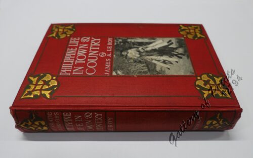
Philippine Life in Town & Country.
₱
8,800.00
Add to cart
Details
Rizal
₱
17,600.00
Add to cart
Details
Bohol
₱
17,600.00
Add to cart
Details
Leyte
₱
17,600.00
Add to cart
Details
Zambales
₱
17,600.00
Add to cart
Details
Map of Pacific Ocean by Robinson H. E. C. Pty. Ltd. Mercat...
₱
14,700.00
Add to cart
Details
South Island New Zealand
₱
4,400.00
Add to cart
Details
Northern Island New Zealand
₱
4,400.00
Add to cart
Details
The Mysteries of Taal: A Philippine Volcano and Lake, Her S...
₱
900.00
Add to cart
Details
Iloilo A Rich and Noble Land
₱
7,500.00
Add to cart
Details
When Britain Ruled the Philippines 1762-1764
₱
2,200.00
Add to cart
Details
Spanish Galleon 1530 – 1690 New Vanguard # 96
₱
2,200.00
Add to cart
Details
The Manila-Acapulco Galleons: The Treasure Ships of the Paci...
₱
4,400.00
Add to cart
Details
The National Geographic Magazine September, 1952, vol. CII, ...
₱
1,100.00
Add to cart
Details
Karte der St. Gotthard-Bahn, Taf.2 [Map of The Gotthard-Rail...
₱
6,600.00
Add to cart
Details
The Far East Compiled and Drawn in the Cartographic Section ...
₱
6,600.00
Add to cart
Details
Philippine Religious – Carvings in Ivory
₱
2,500.00
Add to cart
Details
Filipino Master – Damian Domingo
₱
2,500.00
Add to cart
Details
The Age of Trade The Manila Galleons and the Dawn of the Glo...
₱
6,600.00
Add to cart
Details
Adios, Patria Adorada [The Filipino as Ilustrado, The Ilustr...
₱
990.00
Add to cart
Details
Blue Book of the First Year of the Republic of the Philippin...
₱
24,500.00
Add to cart
Details
Evangelización de Filipinas y del Japon Historia de las Isl...
₱
2,200.00
Add to cart
Details
The Golden Atlas: The Greatest Explorations, Quests and Dis...
₱
3,300.00
Add to cart
Details
Early Mapping of the Pacific The Epic Story of Seafarers, Ad...
₱
6,600.00
Add to cart
Details
Early Maps of South-East Asia
₱
4,400.00
Add to cart
Details
Hinter-Indien und Ostindische Inseln. [Farther India and Eas...
₱
8,800.00
Add to cart
Details
Southeast Asia and Pacific Islands from the Indies and the ...
₱
4,400.00
Add to cart
Details
Habts. des iles Philippines. [Inhabitants of the Philippine...
₱
6,600.00
Add to cart
Details
Num. 18201 Accion de doscientos cincuenta Pesos … [Share o...
₱
50,600.00
Add to cart
Details
Explorers’ Sketchbooks The Art of Discovery & Adve...
₱
3,300.00
Add to cart
Details
The Voyage of the Frigate Pallada [1852-1855]
₱
3,300.00
Add to cart
Details
War Map Pictorial conflict Maps 1900-1950
₱
4,400.00
Add to cart
Details
Maps & Civilization: Cartography in Culture and Society....
₱
2,200.00
Add to cart
Details
The Phantom Atlas The Greatest Myths, Lies and Blunders on M...
₱
3,300.00
Add to cart
Details
A History of the 20th Century in 100 Maps
₱
3,300.00
Add to cart
Details
Ozeanische Kunst [Art of Oceania]
₱
4,400.00
Add to cart
Details
A Treaty of Peace Between the United States and Spain. [Mess...
₱
9,900.00
Add to cart
Details
The Phantom Atlas The Greatest Myths, Lies and Blunders on M...
₱
3,300.00
Add to cart
Details
The Book of Flowers
₱
8,800.00
Add to cart
Details
The Chatelain Atlas
₱
500.00
Add to cart
Details
The Mapmaker’s Art (A History of Cartography)
₱
9,900.00
Add to cart
Details
Maps & Prints for pleasure and investment.
₱
2,500.00
Add to cart
Details
National Geographic March, 1977, Vol.151, No.3 [The Philippi...
₱
1,200.00
Add to cart
Details
National Geographic August, 1972, Vol.142, No.2 [The Tasaday...
₱
1,200.00
Add to cart
Details
The History of Seafaring: Navigating the World’s Ocean...
₱
5,040.00
Add to cart
Details
Japan A Cartographic Vision
₱
4,400.00
Add to cart
Details
The Philippine Islands
₱
16,700.00
Add to cart
Details
Ortelius Atlas Maps 2nd revised edition
₱
5,500.00
Add to cart
Details
The Mapping of Terra Australis
₱
5,500.00
Add to cart
Details
Bel et Utile: The Work of the Robert de Vaugondy Family of M...
₱
6,600.00
Add to cart
Details
Mercator The Man Who Mapped The Planet.
₱
2,200.00
Add to cart
Details
The Atlas of Atlases
₱
4,400.00
Add to cart
Details
Magnificent Maps, Power, Propaganda and Art.
₱
2,200.00
Add to cart
Details
Travel Accounts of the Islands (1513-1787)
₱
6,600.00
Add to cart
Details
Occupied Philippines The Role of Jorge B. Vargas during the ...
₱
4,400.00
Add to cart
Details
Previous
1
2
3
4
5
…
30
31
32
Next
Shopping Cart
1. Embarquement des troupes pour Cuba, a Tampa 2. Depart du "Peking", transportant des troupes a Manille
1
The Philippines- Our Artist with the Firing-Line during the advance on Malolos. 1. Our naval and land forces exchanging signals at night. 2. Wounded insurgents in the rear of their firing-line. 3. Insurgent headquarters at Caloocan, showing effect of American artillery fire. ( Mr. Peters made the Sketch for the Drawing on pages 478 and 479 while confined here. 4. Captain James O'Hara, U.S.A., 3d Artillery.
1
Romblon Island - Port Romblon
1
Decorative Printed Maps of the 15th to 18th Centuries
1
1. Borneo. 2. The Philippine Islands.
1
Vue de Cavite dans la Baie de Manille [View of Cavite in the Bay of Manila]
1
Map of the Philippines. Prepared By Reduction From the Map of the Bureau of Insular Affairs, War Department. Relief Compiled from Maps of the Corps of Engineers, US Army, And from Spanish Surveys.
1
The Cartography of the East Indian Islands, Insulae Indiae Orientalis.
1
Insulae Philippinae Die Philippischen Insuln seyn:
1
The Philipine Isles
1
Isole Filippine
1
East India Isles
1
F.v. Richthofen's Reisen in China Sept. 1868 - 31 Mai 1870, Ney Elias' Aufnahme des Hoangho von Khaifung bis zur Mündung, 1868, Shufeldt's & Febiger's Aufnahmen in Korea, 1867/8.
1
Dr. A. Petermann's Mittheilungen aus Justus Perthes' Geographischer Anstalt. Herausgegeben von Prof. Dr. A. Supan. - Ergänzungsband XXIV (Heft 110-114). 1895 Inhalt: [Supplement Vol. 24 contents] Nr. 110. Bludau, Die Oro- und Hydrographie der preussischen und pommerschen Seenplatte. Nr. 111. Baumann, Die kartographischen Ergebnisse der Massai-Expedition des Deutschen Antisklaverei-Comités. Nr. 112. Radde und Koenig, Das Ostufer des Pontus und seine kulturelle Entwickelung im Verlaufe der letzten 30 Jahre. Nr. 113. Sapper, Grundriss der physikalischen Geographie von Guatemala. Nr. 114. v. Flottwell, Aus dem Stromgebiet des Qyzyl-Yrmaq (Halys).
1
Dendrobium Johnsonæ [White Orchids]
1
[ Mayon Volcano]
1
Sketch of the Engagement of the Prov. Cavalry Brigade. 1st Div. 8th Army Corps Dec 4, 1899. Prepared under the direction of Brig. Genl. S. B. Young.
1
The Philippines. History, Geography, Customs, Agriculture, Industry and Commerce of the Spanish Colonies in Oceania
1
Alegoria de los Santos Reyes (pág. 30.) [Three Kings]
1
Dr. A. Petermann's Mittheilungen aus Justus Perthes' Geographischer Anstalt. Herausgegeben von Prof. Dr. A. Supan. - Ergänzungsband XXII (Heft 101-104). 1892 Inhalt: [Supplement Vol. 22 contents] Nr. 101. Wagner und Supan. Die Bevölkerung der Erde. VIII Nr. 102. Walther, Die Adamsbrücke und die Korallenriffe der Palkstrasse. Nr. 103. Schnell, Das marokkanische Atlasgebirge. Nr. 104. Hettner, Die Kordillere von Bogotá.
1
Saxifraga Purpurascens. [Purple Himalayan Saxifrage] [Purple Bergenia]
1
Cycas Circinalis [Sage Palm Tree]
1
Cart
Checkout
Continue Shopping
22