Tel : +63(2)-7729-8168 | Mobile: +63 917 806 4291
|
Email: gallery@gop.com.ph
My Account
Remember Me
Register
32 Item(s)
-
₱
681,350.00
Les Isles Philippines - Islas de los Ladrones... ou Isles des Larrons
1 x
₱
33,000.00
Für die Sennores Padres zu Manilla.
1 x
₱
11,000.00
The Philippine Islands (Around the World Program)
1 x
₱
4,400.00
Archipiélago Filipino - Isla de Mindanao Plano del Puerto de Pollok
1 x
₱
4,400.00
Progress Map of Signal Corps Telegraph Lines & Cables in the Military Division of the Philippines… corrected to July 1st, 1900.
1 x
₱
26,400.00
Curioser Stätt-Zeiger der vornemsten Städten in Teudschland wie weit solche von ein=ander entlegen seyn. [Distance Table in German Miles Between German Cities]
1 x
₱
3,300.00
Eastern Archipelago. Philippine Islands and Adjacent Seas. From Molucca Sea to Manila Bay. From the United States & Netherlands Governments Charts to 1929. With corrections to 1946.
1 x
₱
11,000.00
Sketch of Navitac and Vicinity
1 x
₱
4,400.00
Anchorages of Luzon, Mindoro and Marinduque. insets: 1) Luzon - West Coast. Bolinao Harbour. From the United States Government Survey of 1904. With additions and corrections from Philippine Gov't. Charts to 1964. 2) Luzon - West Coast. Port Masinloc and Port Matalvi. From the United States Government Surveys of 1937. With additions and corrections from Philippine Gov't. Charts to 1964. 3) Luzon - West Coast. Mariveles Harbour. From the United States Government Chart of 1940. With additions and corrections from Philippine Gov't. Charts to 1964. 4) Luzon - South - West Coast. Batangas. From the Philippine Government Chart of 1956. With additions and corrections to 1964. 5) Luzon - South - West Coast. Nasugbu Bay. From the Philippine Government Chart of 1956. 6) Marinduque. Port Balanacan. From the United States Government Survey of 1908. With additions and corrections from Philippine Gov't. Charts to 1964. 7) Marinduque. Santa Cruz Harbour. From the United States Government Survey of 1908. With additions and corrections from Philippine Gov't. Charts to 1964. 8) Mindoro - North Coast. Port Galera and Varadero Bay. From the United States Government Surveys to 1939. With additions and corrections from Philippine Gov't. Charts to 1964.
1 x
₱
11,000.00
Filipinas. Distrito de Lepanto Description general accompañada de itinerario y croquis del territorio,…
1 x
₱
99,000.00
Manila and the Seat of War
1 x
₱
13,200.00
Mittheilungen der kais. königl. Geographischen Gesellschaft in Wien. 1885 [article:] Ueber die Staaten der philippinischen Eingebornen in den Zeiten der Conquista. [On the States of the Filipino Natives in the times of the Conquista] [article:] Die spanischen Ansprüche auf die Carolinen. [The Spanish Claims to the Carolines] [article:] Bemerkungen zur Karte der Carolinen-Inseln [Notes on the Map of the Carolines]
1 x
₱
18,700.00
Old Manila
1 x
₱
9,900.00
Ponte di Manilla
1 x
₱
22,000.00
Sketches in China. - Hong-Kong Races, 1858. 1. The One-Schilling Stand 2. The Road
1 x
₱
6,600.00
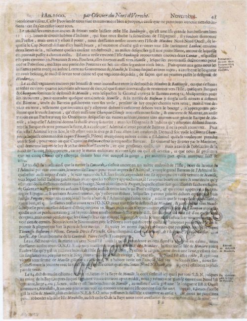
Schlacht for Manille [Battle for Manila] ( Oliver van Noort at Manila against Antonio de Morga)
1 x
₱
49,500.00
Philippine Islands. Surigao Srait with Leyte Gulf and Hinatuan Passage. From the United States Government Charts to 1933. With addition and correctionsto 1954.
1 x
₱
11,000.00
The Philippines - In and about Manila 1. Corregidor Island 2. The Prison, Manila 3. House of the Comandante, Cavité 4. Gate in the Wall at Cavité
1 x
₱
5,500.00
Voyage Around The World On The Corvette La Favorite 1830, 1831, 1832 Under the Command of Captain Laplace.
1 x
₱
2,200.00
Bibliography of the Philippine Islands. Printed and Manuscript. Preceded by a Descriptive Account of the most important Archives and Collections containing Philippina
1 x
₱
4,400.00
A New Map of the World according to Wright's alias Mercator's Projection &c : drawn from the newest and the most exact observations together with a view of the general and coasting trade winds, monsoons or the shifting trade winds with other considerable improvements &c by Ier: Seller and Cha: Price Hydrographers to the Queen at the Hermitage staires and at their shopp nex't the Fleece Taverne in Cornhill ; H: Moll fecit. [inset: North Pole]. [In lower centre margin:] Note, that the arrows among the lines shew the Course of those General and Coasting Trade Winds and the Arrows in the void spaces shew the Course of the Monsoons or Shifting Trade Winds and the Abbreviations Sept. & c. shew the Time of the year when such winds blow.
1 x
₱
125,000.00
The Philippine Islands showing location of Resources and Industries Isthmian Canal Commission Economic Report 1901. Authority for Topographic Data Foreman. The Philippine Islands. 1899. Note: Facts from Foreman verified in most cases by U.S. Government Reports
1 x
₱
46,200.00
[Cloudless Sulphur Butterfly and Caterpillar with Moth]
1 x
₱
6,600.00
City of Manila. Prepared under the direction of the Chief Engineer, GHQ, AFPAC, U.S. Army, by Base Map Plant no. 1, August, 1945.
1 x
₱
41,600.00
Iles Philippines. Vue de la pe. [petite] Ville de Balanga, du cote de la Mer. Islas Filipinas. Vista de la pequeña ciudad de Balanga, del lado del Mar [View of the small town of Balanga by the sea]
1 x
₱
5,500.00
Isla de Mindanao oriental pl. 27 (Misamis, Surigao, Cotabato, Davao,.....with insets of Volcan Apo and Seno de Davao)
1 x
₱
6,600.00
Ethnography of the Major Ethnolinguistic Groups in the Cordillera
1 x
₱
1,100.00
The Philippine Insurrection: The Four Truths
1 x
₱
750.00
Location of Troops in the Philippine Islands March 31, 1900.
1 x
₱
16,500.00
Narcissus Fig. 1 Narcissus pseudo-narcissus [Daffodil / Lent Lily] Diagram I Plan of Flower Diagram II Imbricate Arrangement of Perianth leaves in Bud Fig. 2 Polyanthus Narcissus Inflorescence-an Umbel [Bunch of Lent Lilies with Short Flower Stalks] Fig. 3 Vertical section of Flower of Polyanthus Narcissus Fig. 4 Perianth tube spread out Fig. 5 Stamen with versatile Anther a. lower Stamen unopened b. upper Stamen opened Fig. 6 Transverse section of Ovary Fig. 7 Anatropous Ovule in section
1 x
₱
5,500.00
Asia partiu orbis maxima. MDXCVIII.
1 x
₱
64,100.00
The Life of Ferdinand Magellan and the First Circumnavigation of the Globe. 1480-1521.
1 x
₱
11,000.00
View Cart
Checkout
Home
About Us
Publications
Shop Online
Framing Services
Exhibits
Picture Hanging System
Contact Us
View cart
“The Life of Ferdinand Magellan and the First Circumnavigation of the Globe. 1480-1521.” has been added to your cart.
Sort by
Date
Sort by
Default Order
Sort by
Name
Sort by
Price
Sort by
Date
Sort by
Popularity
Show
30 Products
Show
30 Products
Show
60 Products
Show
90 Products
Océanique: Isles du Scarborough. ‘pl. 16 Note sur le...
₱
8,800.00
Add to cart
Details
Asie: Partie de la Chine pl. 88
₱
19,700.00
Add to cart
Details
La Danese [The Danish]
₱
6,600.00
Add to cart
Details
[Emperor Moth]
₱
6,600.00
Add to cart
Details
[Cloudless Sulphur Butterfly and Caterpillar with Moth]
₱
6,600.00
Add to cart
Details
Salmon
₱
5,500.00
Add to cart
Details
Pike and Perch
₱
5,500.00
Add to cart
Details
Saxifraga Purpurascens. [Purple Himalayan Saxifrage] [Purp...
₱
6,600.00
Add to cart
Details
Masdevallia Harryana Coerulescens. [Flag Orchid]
₱
6,600.00
Add to cart
Details
Der Neue Welt-Bott… Allerhand So Lehr-als Geist-reiche Bri...
₱
99,000.00
Add to cart
Details
Gallia…..
₱
13,200.00
Add to cart
Details
Vingboons-Atlas
₱
49,500.00
Add to cart
Details
East India Isles
₱
18,700.00
Add to cart
Details
East India Isles
₱
18,700.00
Add to cart
Details
Isla de Luzon pl. 10, inset: Pto. de Banacalan [Marinduque]...
₱
6,600.00
Add to cart
Details
Isla de Paragua o Palawan Norte pl. 24 [ Northern Palawan wi...
₱
7,700.00
Add to cart
Details
Pont de Manille (Iles Philippines.) [Manila Bridge (Philipp...
₱
330,000.00
Add to cart
Details
Old Manila
₱
2,800.00
Add to cart
Details
A Chart of the Channel in the Philipine Islands [sic] Throug...
₱
26,400.00
Add to cart
Details
Die Länder Asie nach ihrer gelegenheit… [The Countries o...
₱
88,000.00
Add to cart
Details
Oriolus Chinensis, Linn. [Philippine Oriole] [Black-naped Or...
₱
39,600.00
Add to cart
Details
1) Irena Tweeddalii, 2) I. Melanochlamys. (1. Palawan Fairy...
₱
9,900.00
Add to cart
Details
Plumiera Alba. – Blanco. – Plumeria Acutifolia. ...
₱
39,600.00
Add to cart
Details
Indes Néerlandaises – Iles Philippines – Rap...
₱
39,600.00
Add to cart
Details
Pacifico – Islas Filipinas pl. 1
₱
6,600.00
Add to cart
Details
El indio viejo [The Old Indio]
₱
49,500.00
Add to cart
Details
The Life of Ferdinand Magellan and the First Circumnavigatio...
₱
11,000.00
Add to cart
Details
Ladmiral surmonte s’en allant au fond a nostre veúe
₱
49,600.00
Add to cart
Details
Die Igorot Bergvölker in den Philippinen heute [Mountain ...
₱
2,900.00
Add to cart
Details
En el archipiélago de la Especiería España y Molucas en l...
₱
4,900.00
Add to cart
Details
Previous
1
2
3
…
16
17
18
19
20
21
22
…
57
58
59
Next
Shopping Cart
The Life of Ferdinand Magellan and the First Circumnavigation of the Globe. 1480-1521.
1
Asia partiu orbis maxima. MDXCVIII.
1
Narcissus Fig. 1 Narcissus pseudo-narcissus [Daffodil / Lent Lily] Diagram I Plan of Flower Diagram II Imbricate Arrangement of Perianth leaves in Bud Fig. 2 Polyanthus Narcissus Inflorescence-an Umbel [Bunch of Lent Lilies with Short Flower Stalks] Fig. 3 Vertical section of Flower of Polyanthus Narcissus Fig. 4 Perianth tube spread out Fig. 5 Stamen with versatile Anther a. lower Stamen unopened b. upper Stamen opened Fig. 6 Transverse section of Ovary Fig. 7 Anatropous Ovule in section
1
Location of Troops in the Philippine Islands March 31, 1900.
1
The Philippine Insurrection: The Four Truths
1
Ethnography of the Major Ethnolinguistic Groups in the Cordillera
1
Isla de Mindanao oriental pl. 27 (Misamis, Surigao, Cotabato, Davao,.....with insets of Volcan Apo and Seno de Davao)
1
Iles Philippines. Vue de la pe. [petite] Ville de Balanga, du cote de la Mer. Islas Filipinas. Vista de la pequeña ciudad de Balanga, del lado del Mar [View of the small town of Balanga by the sea]
1
City of Manila. Prepared under the direction of the Chief Engineer, GHQ, AFPAC, U.S. Army, by Base Map Plant no. 1, August, 1945.
1
[Cloudless Sulphur Butterfly and Caterpillar with Moth]
1
The Philippine Islands showing location of Resources and Industries Isthmian Canal Commission Economic Report 1901. Authority for Topographic Data Foreman. The Philippine Islands. 1899. Note: Facts from Foreman verified in most cases by U.S. Government Reports
1
A New Map of the World according to Wright's alias Mercator's Projection &c : drawn from the newest and the most exact observations together with a view of the general and coasting trade winds, monsoons or the shifting trade winds with other considerable improvements &c by Ier: Seller and Cha: Price Hydrographers to the Queen at the Hermitage staires and at their shopp nex't the Fleece Taverne in Cornhill ; H: Moll fecit. [inset: North Pole]. [In lower centre margin:] Note, that the arrows among the lines shew the Course of those General and Coasting Trade Winds and the Arrows in the void spaces shew the Course of the Monsoons or Shifting Trade Winds and the Abbreviations Sept. & c. shew the Time of the year when such winds blow.
1
Bibliography of the Philippine Islands. Printed and Manuscript. Preceded by a Descriptive Account of the most important Archives and Collections containing Philippina
1
Voyage Around The World On The Corvette La Favorite 1830, 1831, 1832 Under the Command of Captain Laplace.
1
The Philippines - In and about Manila 1. Corregidor Island 2. The Prison, Manila 3. House of the Comandante, Cavité 4. Gate in the Wall at Cavité
1
Philippine Islands. Surigao Srait with Leyte Gulf and Hinatuan Passage. From the United States Government Charts to 1933. With addition and correctionsto 1954.
1
Schlacht for Manille [Battle for Manila] ( Oliver van Noort at Manila against Antonio de Morga)
1
Sketches in China. - Hong-Kong Races, 1858. 1. The One-Schilling Stand 2. The Road
1
Ponte di Manilla
1
Old Manila
1
Mittheilungen der kais. königl. Geographischen Gesellschaft in Wien. 1885 [article:] Ueber die Staaten der philippinischen Eingebornen in den Zeiten der Conquista. [On the States of the Filipino Natives in the times of the Conquista] [article:] Die spanischen Ansprüche auf die Carolinen. [The Spanish Claims to the Carolines] [article:] Bemerkungen zur Karte der Carolinen-Inseln [Notes on the Map of the Carolines]
1
Manila and the Seat of War
1
Filipinas. Distrito de Lepanto Description general accompañada de itinerario y croquis del territorio,…
1
Anchorages of Luzon, Mindoro and Marinduque. insets: 1) Luzon - West Coast. Bolinao Harbour. From the United States Government Survey of 1904. With additions and corrections from Philippine Gov't. Charts to 1964. 2) Luzon - West Coast. Port Masinloc and Port Matalvi. From the United States Government Surveys of 1937. With additions and corrections from Philippine Gov't. Charts to 1964. 3) Luzon - West Coast. Mariveles Harbour. From the United States Government Chart of 1940. With additions and corrections from Philippine Gov't. Charts to 1964. 4) Luzon - South - West Coast. Batangas. From the Philippine Government Chart of 1956. With additions and corrections to 1964. 5) Luzon - South - West Coast. Nasugbu Bay. From the Philippine Government Chart of 1956. 6) Marinduque. Port Balanacan. From the United States Government Survey of 1908. With additions and corrections from Philippine Gov't. Charts to 1964. 7) Marinduque. Santa Cruz Harbour. From the United States Government Survey of 1908. With additions and corrections from Philippine Gov't. Charts to 1964. 8) Mindoro - North Coast. Port Galera and Varadero Bay. From the United States Government Surveys to 1939. With additions and corrections from Philippine Gov't. Charts to 1964.
1
Sketch of Navitac and Vicinity
1
Eastern Archipelago. Philippine Islands and Adjacent Seas. From Molucca Sea to Manila Bay. From the United States & Netherlands Governments Charts to 1929. With corrections to 1946.
1
Curioser Stätt-Zeiger der vornemsten Städten in Teudschland wie weit solche von ein=ander entlegen seyn. [Distance Table in German Miles Between German Cities]
1
Progress Map of Signal Corps Telegraph Lines & Cables in the Military Division of the Philippines… corrected to July 1st, 1900.
1
Archipiélago Filipino - Isla de Mindanao Plano del Puerto de Pollok
1
The Philippine Islands (Around the World Program)
1
Für die Sennores Padres zu Manilla.
1
Les Isles Philippines - Islas de los Ladrones... ou Isles des Larrons
1
Cart
Checkout
Continue Shopping
32