Tel : +63(2)-7729-8168
|
Email Us : gallery@gop.com.ph
My Account
Remember Me
Register
2 Item(s)
-
₱
20,900.00
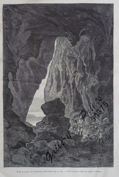
Grotte du Levant; Ile de Cagraray, Golfe d'Albay
1 x
₱
9,900.00
Philippine Islands. Anchorages in Northern Luzon and the Babuyan Islands. Insets: 1) Babuyan Is. - Fuga I. Musa Bay. From the United States Government Chart to 1931. 2) Babuyan Is. - Camiguin I. Port San Pio Quinto. From the United States Government Chart to 1931. 3) Luzon-North-East Coast Port San Vicente. From the United States Government Chart to 1938. 4) Luzon - East Coast Mauban Anchorage. From the Philippine Government Chart of 1957. 5) Luzon - West Coast. Salomague Harbour and Lapog Bay. From the United States Government Chart of 1934. 6) Luzon - West Coast Port Currimao and Gan Bay. From the United States Government Chart of 1934. 7) Luzon - West Coast Solvec Cove. From the United States Government Chart of 1934. 8) Luzon - West Coast Lingayen Gulf. Port Sual with Cabalitian Bay. From the United States Government Chart of 1922. 9) Luzon - West Coast San Fernando Harbour. From the United States Government Chart of 1936.
1 x
₱
11,000.00
View Cart
Checkout
Home
About Us
Publications
Shop Online
Framing Services
Exhibits
Picture Hanging System
Contact Us
Sort by
Default Order
Sort by
Default Order
Sort by
Name
Sort by
Price
Sort by
Date
Sort by
Popularity
Show
30 Products
Show
30 Products
Show
60 Products
Show
90 Products
Saxifraga Purpurascens. [Purple Himalayan Saxifrage] [Purp...
₱
6,600.00
Add to cart
Details
Acacia Linifolia [White Wattle or Flax Wattle]
₱
5,500.00
Add to cart
Details
Dalea Bicolor [Silver Prarie Clover]
₱
5,500.00
Add to cart
Details
Elletaria Speciosa. Bl.[ume] [Philippine Waxflower; Torch Gi...
₱
49,500.00
Add to cart
Details
Shopping Cart
Philippine Islands. Anchorages in Northern Luzon and the Babuyan Islands. Insets: 1) Babuyan Is. - Fuga I. Musa Bay. From the United States Government Chart to 1931. 2) Babuyan Is. - Camiguin I. Port San Pio Quinto. From the United States Government Chart to 1931. 3) Luzon-North-East Coast Port San Vicente. From the United States Government Chart to 1938. 4) Luzon - East Coast Mauban Anchorage. From the Philippine Government Chart of 1957. 5) Luzon - West Coast. Salomague Harbour and Lapog Bay. From the United States Government Chart of 1934. 6) Luzon - West Coast Port Currimao and Gan Bay. From the United States Government Chart of 1934. 7) Luzon - West Coast Solvec Cove. From the United States Government Chart of 1934. 8) Luzon - West Coast Lingayen Gulf. Port Sual with Cabalitian Bay. From the United States Government Chart of 1922. 9) Luzon - West Coast San Fernando Harbour. From the United States Government Chart of 1936.
1
Grotte du Levant; Ile de Cagraray, Golfe d'Albay
1
Cart
Checkout
Continue Shopping
2