Tel : +63(2)-7729-8168 | Mobile: +63 917 806 4291
|
Email: gallery@gop.com.ph
My Account
Remember Me
Register
Cart
My Account
Cart
Home
About Us
Publications
Shop Online
Framing Services
Exhibits
Picture Hanging System
Contact Us
Blogs
Home
About Us
Publications
Shop Online
Framing Services
Exhibits
Picture Hanging System
Contact Us
Blogs
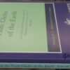
Compassing the Vaste Globe of the Earth…
₱
2,600.00
In Stock
In Stock
Add to cart
Author:
R.C. Bridges / P.E.H. Bridges
Publisher:
The Hakluyt Society, in London.
Year:
1996
Size:
21.5 x13.5 cm
Reference:
SKU:
20670
Category:
Vintage Prints/Maps/Views[1926-1999]
Tag:
History 4
Description
Condition
Description
published by The Hakluyt Society in London..
Condition
Very good condition.
Share On Facebook
Tweet This Product
Pin This Product
Mail This Product
Related products
Philippine Islands. Leyte Gulf To Mayo Bay. Including Leyte,Parts of Sebu and Bohol and the North-Eastern Cost of Mindanao. From the United States Cost Survey Charts to 1922.
₱
11,000.00
Add to cart
Details
Philippine Islands. Camotes Sea with Canigao Chanel. From the United States Government Charts to 1932. with corrections to 1934.
₱
11,000.00
Add to cart
Details
Philippine Islands. Tagolo Point to Cuyo Islands. Including Sebu Negros and Parts of Panay and Palawan. From the United States Coast Survey Charts to 1923.
₱
11,000.00
Add to cart
Details
Philippine Islands. Western Part of Mindanao Sea with Bohol Strait and Part of Tañon Strait. From the United States Government Charts to 1937.
₱
13,200.00
Add to cart
Details
Philippine Islands. Surigao Srait with Leyte Gulf and Hinatuan Passage. From the United States Government Charts to 1933. With addition and correctionsto 1954.
₱
11,000.00
Add to cart
Details
Philippine Islands. Tagolo Point to Cuyo Islands. Including Sebu , Negros and Parts of Panay and Palawan. From the United States Coast Survey Charts to 1923.
₱
11,000.00
Add to cart
Details
Ports in the Philippine Islands. insets: 1) Luzon I. – West Coast. Manila and Cavite Anchorages. From the United States Government Charts to 1950. With additions and corrections to 1959. 2) Luzon I. – West Coast. Manila Harbour. From the United States Government Charts to 1950. With additions and corrections to 1959.
₱
13,200.00
Add to cart
Details
Philippine Islands. Cuyo West Pass. From the United States Government Charts to 1933. With additions and corrections to 1955.
₱
13,200.00
Add to cart
Details
Ports in the Philippine Islands. insets: 1) Luzon I. – West Coast. Manila and Cavite Anchorages. From the United States Government Chart of 1950. with additions and corrections to 1969. 2) Luzon I. – West Coast. Manila Harbour. From the United States Government Chart of 1950. with additions and corrections to 1969.
₱
11,000.00
Add to cart
Details
China Sea – Philippine Islands. San Bernardino Strait and Approaches. From the United States Coast Survey Charts to 1923. with additions and corrections to 1934.
₱
11,000.00
Add to cart
Details
Shopping Cart
There are no products in the cart!
Continue Shopping
0
")
")
")
")