Tel : +63(2)-7729-8168 | Mobile: +63 917 806 4291
|
Email: gallery@gop.com.ph
My Account
Remember Me
Register
8 Item(s)
-
₱
195,180.00
Southern Luzon. Showing portion of Theatre of Operations. 8th Army Corps, Major Gen. Elwell S. Otis, commanding. - Prepared under the direction of Gen. Otis by Wm L. Sibert, Captain, Corps of Engineers, U.S. Army.
1 x
₱
61,600.00
Chute d'Eau a Hala-Hala [Waterfalls at Jala-Jala]
1 x
₱
39,600.00
Rizal
1 x
₱
17,600.00
Philippine Islands - Mindanao. Davao Gulf. From the Philippine Government Charts to 1956. With additions and corrections to 1962. insets: 1) Talomo Bay. From U.S Government Chart of 1933. With additions and corrections to 1962. 2) Lais. From U.S Government Chart of 1933. With additions and corrections to 1962. 3) Malita. From U.S Government Chart of 1933. With additions and corrections to 1962. 4) Port of Davao. From the Philippine Government Chart of 1956. With additions and corrections to 1962. 5) Pakiputan Strait. From U.S Government Chart of 1933. With additions and corrections to 1962.
1 x
₱
11,000.00
The United States of America Including all its Newly Acquired Territory
1 x
₱
46,200.00
The Story of the Philippines and our new Possessions
1 x
₱
5,980.00
Calao à bec rouge, du Sénégal [Red-billed Hornbill from Senegal]
1 x
₱
6,600.00
The Far East Compiled and Drawn in the Cartographic Section of the National Geographic Society for The National Geographic Magazine inset: Korea
1 x
₱
6,600.00
View Cart
Checkout
Home
About Us
Publications
Shop Online
Framing Services
Exhibits
Picture Hanging System
Contact Us
Blogs
View cart
“The Far East Compiled and Drawn in the Cartographic Section of the National Geographic Society for The National Geographic Magazine inset: Korea” has been added to your cart.
Sort by
Date
Sort by
Default Order
Sort by
Name
Sort by
Price
Sort by
Date
Sort by
Popularity
Show
30 Products
Show
30 Products
Show
60 Products
Show
90 Products
Philippine Religious – Carvings in Ivory
₱
2,500.00
Add to cart
Details
The Far East Compiled and Drawn in the Cartographic Section ...
₱
6,600.00
Add to cart
Details
Karte der St. Gotthard-Bahn, Taf.2 [Map of The Gotthard-Rail...
₱
5,280.00
Add to cart
Details
The National Geographic Magazine September, 1952, vol. CII, ...
₱
1,100.00
Add to cart
Details
The Manila-Acapulco Galleons: The Treasure Ships of the Paci...
₱
4,400.00
Add to cart
Details
Spanish Galleon 1530 – 1690 New Vanguard # 96
₱
2,200.00
Add to cart
Details
When Britain Ruled the Philippines 1762-1764
₱
2,200.00
Add to cart
Details
Iloilo A Rich and Noble Land
₱
7,500.00
Add to cart
Details
The Mysteries of Taal: A Philippine Volcano and Lake, Her S...
₱
900.00
Add to cart
Details
Northern Island New Zealand
₱
4,400.00
Add to cart
Details
South Island New Zealand
₱
4,400.00
Add to cart
Details
Map of Pacific Ocean by Robinson H. E. C. Pty. Ltd. Mercat...
₱
14,700.00
Add to cart
Details
Zambales
₱
17,600.00
Add to cart
Details
Leyte
₱
17,600.00
Add to cart
Details
Bohol
₱
17,600.00
Add to cart
Details
Rizal
₱
17,600.00
Add to cart
Details
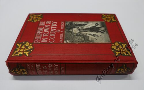
Philippine Life in Town & Country.
₱
8,800.00
Add to cart
Details
Philippines
₱
8,800.00
Add to cart
Details
The Mapping of the Heavens
₱
1,980.00
Add to cart
Details
Manila Harbor Complimentary Map of the City of Manila
₱
22,000.00
Add to cart
Details
Previous
1
2
3
…
60
61
62
63
Shopping Cart
The Far East Compiled and Drawn in the Cartographic Section of the National Geographic Society for The National Geographic Magazine inset: Korea
1
Calao à bec rouge, du Sénégal [Red-billed Hornbill from Senegal]
1
The Story of the Philippines and our new Possessions
1
The United States of America Including all its Newly Acquired Territory
1
Philippine Islands - Mindanao. Davao Gulf. From the Philippine Government Charts to 1956. With additions and corrections to 1962. insets: 1) Talomo Bay. From U.S Government Chart of 1933. With additions and corrections to 1962. 2) Lais. From U.S Government Chart of 1933. With additions and corrections to 1962. 3) Malita. From U.S Government Chart of 1933. With additions and corrections to 1962. 4) Port of Davao. From the Philippine Government Chart of 1956. With additions and corrections to 1962. 5) Pakiputan Strait. From U.S Government Chart of 1933. With additions and corrections to 1962.
1
Rizal
1
Chute d'Eau a Hala-Hala [Waterfalls at Jala-Jala]
1
Southern Luzon. Showing portion of Theatre of Operations. 8th Army Corps, Major Gen. Elwell S. Otis, commanding. - Prepared under the direction of Gen. Otis by Wm L. Sibert, Captain, Corps of Engineers, U.S. Army.
1
Cart
Checkout
Continue Shopping
8